
Boise is the capital and most populous city of the U.S. state of Idaho and is the county seat of Ada County. As of the 2020 census, there were 235,684 people residing in the city. On the Boise River in southwestern Idaho, it is 41 miles (66 km) east of the Oregon border and 110 miles (177 km) north of the Nevada border. The downtown area's elevation is 2,704 feet (824 m) above sea level.

Canyon County is located in the U.S. state of Idaho. As of the 2020 Census, the population was 231,105, making it the second-most populous county in Idaho. The county seat is Caldwell, and its largest city is Nampa. Canyon County is part of the Boise metropolitan area.

Boise County is a rural mountain county in the U.S. state of Idaho. As of the 2020 United States Census, the population was 7,610. The county seat is historic Idaho City, which is connected through a series of paved and unpaved roads to Lowman, Centerville, Placerville, Pioneerville, Star Ranch, Crouch, Garden Valley, and Horseshoe Bend.

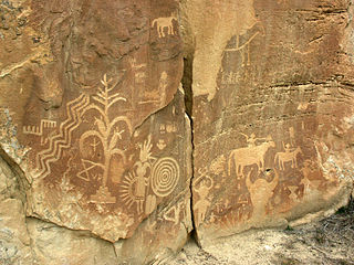
A petroglyph is an image created by removing part of a rock surface by incising, picking, carving, or abrading, as a form of rock art. Outside North America, scholars often use terms such as "carving", "engraving", or other descriptions of the technique to refer to such images. Petroglyphs, estimated to be 20,000 years old are classified as protected monuments and have been added to the tentative list of UNESCO's World Heritage Sites. Petroglyphs are found worldwide, and are often associated with prehistoric peoples. The word comes from the Greek prefix petro-, from πέτρα petra meaning "stone", and γλύφω glýphō meaning "carve", and was originally coined in French as pétroglyphe.
The Timbisha are a Native American tribe federally recognized as the Death Valley Timbisha Shoshone Band of California. They are known as the Timbisha Shoshone Tribe and are located in south central California, near the Nevada border. As of the 2010 Census the population of the Village was 124. The older members still speak the ancestral language, also called Timbisha.
Fort Boise is either of two different locations in the western United States, both in southwestern Idaho. The first was a Hudson's Bay Company (HBC) trading post near the Snake River on what is now the Oregon border, dating from the era when Idaho was included in the British fur company's Columbia District. After several rebuilds, the fort was ultimately abandoned in 1854, after it had become part of United States territory following settlement in 1846 of the northern boundary dispute.

Hells Canyon National Recreation Area is a United States national recreation area on the borders of the U.S. states of Oregon and Idaho. Managed by the U.S. Forest Service as part of the Wallowa-Whitman National Forest, the recreation area was established by Congress and signed by President Gerald Ford in late 1975 to protect the historic and archaeological values of the Hells Canyon area and the area of the Snake River between Hells Canyon Dam and the Oregon–Washington border.
The Crow Canyon Archaeological District is located in the heart of the Dinétah region of the American Southwest in Rio Arriba and San Juan counties in New Mexico approximately 30 miles southeast of the city of Farmington. This region, known to be the ancestral homeland of the Navajo people, contains the most extensive collection of Navajo and Ancient Pueblo petroglyphs or rock art in the United States. Etched into rock panels on the lower southwest walls of the canyon are petroglyphs or rock art depicting what is believed to be ceremonial scenes and symbolic images that represent the stories, traditions and beliefs of the Navajo people. Dating back to the 16th, 17th, and 18th centuries, the petroglyphs have maintained their integrity despite the environmental conditions of the canyon and the effects of tourism. Among the ruins in the Crow Canyon Archaeological District there is also a cluster of Navajo defensive structures or pueblitos, which were built in the 18th century during periods of conflict with the Utes and the beginnings of Spanish Colonialism.

Wilson Butte Cave is located on the Snake River plain in Jerome County northeast of Twin Falls and southeast of Shoshone, Idaho. Listed on the National Register of Historic Places as an archeological site, it is maintained by the Bureau of Land Management (BLM).

Coso Rock Art District is a rock art site containing over 100,000 Petroglyphs by Paleo-Indians and/or Native Americans. The district is located near the towns of China Lake and Ridgecrest, California. Big and Little Petroglyph Canyons were declared a National Historic Landmark in 1964. In 2001, they were incorporated into this larger National Historic Landmark District. There are several other distinct canyons in the Coso Rock Art District besides the Big and Little Petroglyph Canyons. Also known as Little Petroglyph Canyon and Sand Tanks, Renegade Canyon is but one of several major canyons in the Coso Range, each hosting thousands of petroglyphs. The majority of the Coso Range images fall into one of six categories: bighorn sheep, entopic images, anthropomorphic or human-like figures, other animals, weapons & tools, and "medicine bag" images. Scholars have proposed a few potential interpretations of this rock art. The most prevalent of these interpretations is that they could have been used for rituals associated with hunting.

This is a list of the National Register of Historic Places listings in Pueblo County, Colorado, USA.

State Highway 21 (SH-21), also known as the Ponderosa Pine Scenic Byway, is a state highway in Idaho. It runs from Boise to Stanley, primarily as a two-lane road. With two-thirds of its length in Boise County, it passes by historic Idaho City and the village of Lowman to the western edge of the Sawtooth Mountains, then along their northern boundary to Stanley.
Celebration Park is an archaeological park in the western United States, located in southwestern Idaho. It is the state's first archeological park and is adjacent to the Snake River near Melba and Walter's Ferry in Canyon County.

The Guffey Butte–Black Butte Archeological District is a 14,000 acres (57 km2) historic district in southwestern Idaho, United States, that is listed on the National Register of Historic Places (NRHP). It includes numerous archeological sites in Ada, Canyon, Elmore, and Owyhee counties.
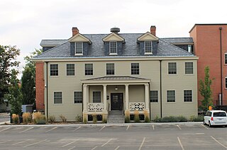
The Eichelberger Apartments in Boise, Idaho, is a 2-story, Colonial Revival building designed by Tourtellotte & Hummel and constructed in 1910. The U-shape, brick and stucco design features corner quoins and keystoned windows with a roofline parapet covered between crested pilasters. It was included as a contributing property in the Fort Street Historic District on November 12, 1982. The building was individually listed on the National Register of Historic Places on November 17, 1982.
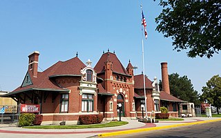
The Nampa Depot in Nampa, Idaho, is a former passenger station on the Oregon Short Line Railroad, designed by Frederick W. Clarke. The 1-story, brick and sandstone depot was described in 1972 by Arthur A. Hart, director of the Idaho State Historical Museum, as "an interesting eclectic combination of Romanesque, Renaissance, and Baroque elements, with the latter dominating. A massive central block of French Renaissance form is flanked by two advancing Baroque bays that bulge dramatically forward." The depot was added to the National Register of Historic Places in 1972.

The Nampa and Meridian Irrigation District Office in Nampa, Idaho, is a 1-story brick and concrete building designed by Tourtellotte and Hummel and completed in 1919. The building features tall, narrow window fenestrations topped by large, vertical keystones with sidestones. Most of the windows have been replaced by a flat stucco surface painted brilliant white. The site was listed on the National Register of Historic Places in 1982.

The New York Canal is an irrigation canal in the western United States, located in southwestern Idaho. Sourced from the Boise River, it originates at the Diversion Dam in Ada County and ends after 41 miles (66 km) at Lake Lowell in Canyon County.

The William Dunbar House in Boise, Idaho, is a 1-story Colonial Revival cottage designed by Tourtellotte & Hummel and constructed by contractor J.O. Jordan in 1923. The house features clapboard siding and lunettes centered within lateral gables, decorated by classicizing eave returns. A small, gabled front portico with barrel vault supported by fluted Doric columns and pilasters decorates the main entry on Hays Street. The house was listed on the National Register of Historic Places in 1982.


