
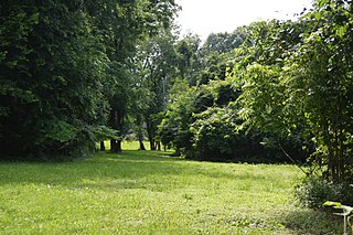
The Grand Village of the Illinois, also called Old Kaskaskia Village, is a site significant for being the best documented historic Native American village in the Illinois River valley. It was a large agricultural and trading village of Native Americans of the Illinois confederacy, located on the north bank of the Illinois River near the present town of Utica, Illinois. French explorers Louis Joliet and Father Jacques Marquette came across it in 1673. The Kaskaskia, a tribe of the Illiniwek people lived in the village. It grew rapidly after a French mission and fur trading post were established there in 1675, to a population of about 6,000 people in about 460 houses. Around 1691 the Kaskaskia and other Illiniwek moved further south, abandoning the site due to pressure from an Iroquois invasion from the northeast.

The Modoc Rock Shelter is a rock shelter or overhang located beneath the sandstone bluffs that form the eastern border of the Mississippi River floodplain at which Native American peoples lived for thousands of years. This site is significant for its archaeological evidence of thousands of years of human habitation during the Archaic period in the Eastern United States. It is located on the northeastern side of County Road 7 southeast of Prairie du Rocher in Randolph County, Illinois, United States. It was declared a National Historic Landmark in 1961.
The Schultz site, also known as Mira Creek site, and designated by archaeologists with the Smithsonian trinomial 25 VY 1, is a major prehistoric archaeological site near North Loup, Nebraska. It is the largest Middle Woodland period site in the state, covering 30,000 square feet (2,800 m2), with layers suggestive of repeated occupation. It is one of the oldest sites in the state exhibiting evidence of pottery manufacture. It was declared a National Historic Landmark in 1964.
Barton Village Site, also known as the Herman Barton Indian Village Archeological Site, is a large, multi-component archaeological site near Cumberland in Allegany County, Maryland.

This is a list of the National Register of Historic Places listings in Wythe County, Virginia.

The Plum Island Eagle Sanctuary is a 52-acre island in the Illinois River owned by the Illinois Audubon Society. It was purchased March 24, 2004 to act as a wildlife sanctuary, to protect foraging habitat for wintering bald eagles. It is close to Matthiessen State Park and adjacent to Starved Rock State Park.
Potomac Creek, or 44ST2, is a late Native American village located on the Potomac River in Stafford County, Virginia. It is from the Woodland Period and dates from 1300 to 1550. There is another Potomac Creek site, 44ST1 or Indian Point, which was occupied by the Patawomeck during the historic period and is where Captain John Smith visited. This site no longer exists, as it eroded away into the river. Site 44ST2 has five ossuaries, one individual burial, and one multiple burial. Other names for the site are Potowemeke and Patawomeke. The defining features include distinctive ceramics, ossuary burials, and palisade villages.

The Summer Island site, designated 20DE4, is an archaeological site located on the northwest side of Summer Island, in Delta County, Michigan. It is classified as a stratified, multi-component site with Middle Woodland, Upper Mississippian and Early Historic/Protohistoric occupations. It was listed on the National Register of Historic Places in 1971.

The Juntunen site, also known as 20MK1, is a stratified prehistoric Late Woodland fishing village located on the western tip of Bois Blanc Island. It was listed on the National Register of Historic Places in 1978.

The Ellerbusch site (12-W-56) is a small but significant archaeological site in the southwestern part of the U.S. state of Indiana. Unlike many sites created by people of the same culture, it occupies an upland site near a major river floodplain. Its existence appears to have been the result of the coincidence of periods of peace and growth in the related Angel site, which led some townspeople to leave their homes for new villages that were more convenient for resource gathering. Researched partly because of its small size, Ellerbusch has produced information that greatly increases present awareness of other small sites and of its culture's overall patterns of settlement in the region. Because of its archaeological value, the site was declared a historic site in the late twentieth century.
The KYANG site, also known as the Kentucky Air National Guard site or 15JF267, is a prehistoric archaeological site located on the grounds of the Louisville Air National Guard Base in Louisville, Kentucky. The site was occupied from the Early Archaic period to the Late Woodland period. The site includes two zones, both of which contain extensive midden deposits. Burials were also conducted at the site, and human remains have been recovered from both zones. The site was discovered in 1972 during construction work at the base; formal excavations at the site began the following year.
The Beaver Meadow Brook Archeological Site is a prehistoric Native American village or camp site in New Hampshire. Located near Sewall's Falls on the west bank of the Merrimack River, the site includes evidence of occupation during Middle and Late Archaic periods, as well as during the Woodland precontact period. Finds at the site include a stone axe and numerous tools for working stone, as well as projectile points and bone fragments. The site also has several hearths, evidence of significant occupation during the Woodland period.

The Cornett Archeological Site (44WY1) is a prehistoric and historic Native American site in Wythe County, Virginia. The site is located on a terrace above the north bank of the New River, about 0.5 miles (0.80 km) outside Austinville. It is a village site, which was occupied during the Late Woodland period, and offers evidence of significantly earlier occupation. The village had a well-defined plaza area, and may have been surrounded by a palisade. Formal excavations of the site have recovered pottery sherds, stone tools, and ceramic and metal trade items. The site has also been subjected to excavations by local collectors.

The Hidden Valley Rockshelter (44-BA-31) is a significant archaeological site located near the community of Warm Springs in Bath County, Virginia, United States. A large rockshelter located near the Jackson River, it has been occupied by humans for thousands of years, and it has been named a historic site.
The St. Croix River Access Site is a prehistoric Native American archaeological site on the St. Croix River in Stillwater Township, Minnesota, United States. It consists of a habitation site with a large quantity of stone tool artifacts, occupied from roughly 800 to 1700 CE. It was listed on the National Register of Historic Places in 1984 for having local significance in the theme of archaeology. It was nominated for its scientific potential to illuminate Late Woodland period cultural relationships, lithic technology, and resource use.

The Moccasin Bluff site is an archaeological site located along the Red Bud Trail and the St. Joseph River north of Buchanan, Michigan. It was listed on the National Register of Historic Places in 1977, and has been classified as a multi-component prehistoric site with the major component dating to the Late Woodland/Upper Mississippian period.
The King Coulee Site is a prehistoric Native American archaeological site in Pepin Township, Minnesota, United States. It was listed on the National Register of Historic Places in 1994 for having state-level significance in the theme of archaeology. It was nominated for being a largely undisturbed occupation site with intact stratigraphy and numerous biofacts stretching from the late Archaic period to the Oneota period. This timeframe spans roughly from 3,500 to 500 years ago. The site yielded the oldest known evidence of domesticated plants in Minnesota: seeds dated to 2,500 years ago from the squash Cucurbita pepo.
The Clampitt site (12Lr329) is a prehistoric archaeological site that sits on a sandy terrace along the East Fork of White River, southeast of Bedford in Lawrence County, Indiana. The site was excavated by the Indiana University archaeological field school in the summers of 1991 and 1992. The Clampitt site was added to the National Register of Historic Places in 2016. The site is located on private property. It is one of thirteen National Register of Historic Places listings in Lawrence County, Indiana.
The Carcajou Point site is located in Jefferson County, Wisconsin, on Lake Koshkonong. It is a multi-component site with prehistoric Upper Mississippian Oneota and Historic components.

The Mero site is a stratified, multicomponent prehistoric site located on the south side of Marshall's Point on the Door Peninsula in Door County, Wisconsin. It was excavated in 1960 by Ronald and Carol Mason under the auspices of the Neville Public Museum in Green Bay, Wisconsin, with financial backing from the landowner, Peter Mero.

