Scenic State Park is a Minnesota state park near Bigfork in Itasca County. It encompasses 3,936 acres (1,593 ha) of virgin pine forests that surround Coon and Sandwick Lakes. It also includes portions of Lake of the Isles, Tell Lake, Cedar Lake and Pine Lake. Established in 1921, the Ojibwe tribe had previously used the area for hunting. The park has places for camping, hiking, swimming, fishing, and canoeing.

Backbone State Park is Iowa's oldest state park, dedicated in 1919. Located in the valley of the Maquoketa River, it is approximately three miles (5 km) south of Strawberry Point in Delaware County. It is named for a narrow and steep ridge of bedrock carved by a loop of the Maquoketa River originally known as the Devil's Backbone. The initial 1,200 acres (490 ha) were donated by E.M. Carr of Lamont, Iowa. Backbone Lake Dam, a relatively low dam built by the Civilian Conservation Corps (CCC) in the 1930s, created Backbone Lake. The CCC constructed a majority of trails and buildings which make up the park.

The Black Moshannon State Park Historic Districts are three separate historic districts on the National Register of Historic Places (NRHP) at Black Moshannon State Park in Rush Township, Centre County, Pennsylvania in the United States. The structures in the historic districts were constructed in the 1930s during the Great Depression by the Civilian Conservation Corps (CCC). The three districts are: the Beach and Day Use District, with 18 contributing structures, including 11 different picnic pavilions, concession building, bathhouse, museum, and four open pit latrines; the Family Cabin District with 16 contributing properties, including 13 cabins, one lodge and two latrines; and the Maintenance District with four contributing properties, including a storage building, three-bay garage, gas pump house, and ranger's residence.

Spencer State Forest is a Massachusetts state forest and recreation reserve located in the town of Spencer, managed by the Massachusetts Department of Conservation and Recreation. The 92 mile (148 km) Midstate Trail passes through the state forest. The Commonwealth of Massachusetts also conducts logging in some parts of the property.

Oak Lodge is a historic recreational building, located on the west side of Schreeder Pond in Chatfield Hollow State Park in Killingworth, Connecticut. Built in 1937, it is one of Connecticut's finest examples of construction by crews of the Civilian Conservation Corps (CCC). It, along with Schreeder Pond and other CCC-built park features, was listed on the National Register of Historic Places in 1986.

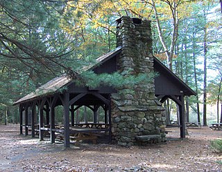
The American Legion Forest CCC Shelter is a historic rustic log shelter, located on the west side of West River Road within the American Legion State Forest in Barkhamsted, Connecticut. It is the only surviving one of four such structures in the area built by the Civilian Conservation Corps (CCC), and one of only three CCC-built shelters to survive in the state. The shelter was listed on the National Register of Historic Places in 1986.

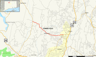
Hopeville Pond State Park is a public recreation area located on Hopeville Pond, an impoundment of the Pachaug River, in the town of Griswold, Connecticut. A portion of the 554-acre (224 ha) state park occupies the site of the lost village of Hopeville. The park manager's house occupies Avery House, which is listed on the National Register of Historic Places. The park offers fishing, swimming, camping, and trails for hiking and biking. It is managed by the Connecticut Department of Energy and Environmental Protection.

The Bear Brook State Park Civilian Conservation Corps (CCC) Camp Historic District is the only surviving Civilian Conservation Corps work camp in New Hampshire. Located in Bear Brook State Park, in Allenstown, the camp's facilities have been adaptively reused to provide space for park administration and a small museum. It is located in the northwestern portion of the park, south of Deerfield Road. It is also believed to be one of the few relatively intact CCC camps in the nation. The district was listed on the National Register of Historic Places in 1992.

The Thayer Lake South Shelter Cabin is a historic backcountry shelter in the Admiralty Island National Monument, part of the Tongass National Forest in Southeast Alaska. It was one of a number of such facilities built by Civilian Conservation Corps (CCC) on the Admiralty Island Canoe Route between 1933 and 1937. This cabin, a three-sided Adirondack-style log structure with shake walls and roof, was built in 1935, and is located near the southern tip of Thayer Lake, facing a reedy stream blocked by a beaver dam. A portage trail runs nearby.

Upton State Forest is a publicly owned forest with recreational features primarily located in the town of Upton, Massachusetts, with smaller sections in the towns of Hopkinton and Westborough. The state forest encompasses nearly 2,800 acres (1,100 ha) of publicly accessible lands and includes the last remaining Civilian Conservation Corps (CCC) camp in Massachusetts, built in National Park Service rustic style. The CCC campground was listed on the National Register of Historic Places in 2014.

Shady Lake Recreation Area is a campground and public recreation area in southwestern Ouachita National Forest, southwest of Mena, Arkansas and west of Glenwood, Arkansas. The area is oriented around Shady Lake, a body of water on the South Fork Saline River impounded by a dam built c. 1940 by the Civilian Conservation Corps (CCC). The area is administered by the United States Forest Service (USFS).

The Paugnut Forest Administration Building is a historic building at 385 Burr Mountain Road in Burr Pond State Park, Torrington, Connecticut. Built in 1937 by a crew of the Civilian Conservation Corps (CCC), it is one of the finest examples of Bungalow/Craftsman architecture built by the CCC in the state. It was listed on the National Register of Historic Places in 1986.

Beeds Lake State Park is located northwest of Hampton, Iowa, United States. It was listed has a historic district on the National Register of Historic Places as Beeds Lake State Park, Civilian Conservation Corps Area in 1990. At the time of its nomination it contained 21 resources, which included one contributing building, 15 contributing structures, and five non-contributing structures. The 319-acre (129 ha) park surrounds a 99-acre (40 ha) reservoir. It features hiking trails, boating, fishing, swimming, camping, picnic areas and shelters, lodges and concessions.

Lacey-Keosauqua State Park is located southwest of Keosauqua, Iowa, United States. Located along the Des Moines River in Van Buren County, it was dedicated in 1921. It is the largest state park in size in Iowa. In 1990 three areas were named nationally recognized historic districts and listed on the National Register of Historic Places.

New Discovery State Park is a state park near Marshfield, Vermont in the United States. It is one of seven state parks located in Groton State Forest. The park is on Vermont Route 232, offering camping, picnicking, and access to forest trails. The park was developed in the 1930s by the Civilian Conservation Corps; its major CCC-built facilities, located mainly in western Peacham, were listed on the National Register of Historic Places in 2002.
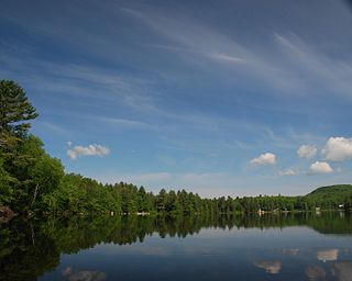
Ricker Pond State Park is a state park in Groton, Vermont in the United States. It is one of seven state parks located in Groton State Forest. The park is just off Vermont Route 232. The park provides public access to Ricker Pond, a 95-acre (38 ha) lake in central Groton, and was developed in the 1930s by crews of the Civilian Conservation Corps. Activities includes camping, motor boating, waterskiing, fishing, swimming, paddling, horseback riding, hiking, mountain biking, snowshoeing and cross-country skiing. The park is open between the Memorial Day and Columbus Day weekends; fees are charged for day use and camping.
The Cream Hill Shelter is a historic rustic log shelter in Housatonic State Forest in Cornwall, Connecticut. Built in 1935, it is one three surviving log shelters constructed by the Civilian Conservation Corps in Connecticut. It was listed on the National Register of Historic Places in 1986.