
West Overton is a historic village located approximately 40 miles (64 km) southeast of Pittsburgh, in East Huntingdon Township, Westmoreland County, Pennsylvania, United States. It is on PA 819 between the towns of Mount Pleasant and Scottdale. Its latitude is 40.117N and its longitude is -79.564W. Known as the birthplace of industrialist and art collector Henry Clay Frick, it is also the original site of the distillery founded by his great-grandfather, Henry Overholt, and later operated by his grandfather, Abraham Overholt. This distillery is famous for producing Old Overholt rye whiskey.
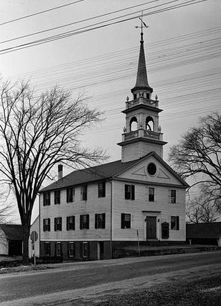
Preston City is a village and the original town center of the town of Preston, Connecticut, United States. The core of the village around the junction of Old Northwest Road and Route 164 is designated as the Preston City Historic District, a historic district that is listed on the National Register of Historic Places. The district is located along Old Shetucket and Amos Roads, which, prior to the 1930s, were major thoroughfares.

The Faeth Farmstead and Orchard District is a nationally recognized historic district located near Fort Madison, Iowa, United States. At the time of its nomination it contained 27 resources, which included 15 contributing buildings, three contributing sites, three contributing structures, and six non-contributing buildings. The contributing buildings include the farm house, the main barn (1882), a stable, a privy, engine house, smokehouse, chicken house, and hog house all from the early 1900s, a shop/crib, a second barn (1925), an apple packing shed, an apple cold storage shed or cooler with loading dock, a truck shed, a garage (1950s) and a machine shed. The contributing structures include a pond that was used for spraying apples, a spray tank/house (1946), and an old section of road. The contributing sites are the three historic orchards. The East Orchard was established before 1874 and it still has remnant older trees. The Old North Orchard was established around the turn of the 20th century, but the trees were primarily planted in the 1970s and the 1980s. The North Orchard was established in 1940-1941 and includes some remnant older trees and replacement trees from the 1970s to the 1990s. The non-contributing buildings are more recently built, or moved here in recent years.

There are 77 properties listed on the National Register of Historic Places in Albany, New York, United States. Six are additionally designated as National Historic Landmarks (NHLs), the most of any city in the state after New York City. Another 14 are historic districts, for which 20 of the listings are also contributing properties. Two properties, both buildings, that had been listed in the past but have since been demolished have been delisted; one building that is also no longer extant remains listed.

Harlinsdale Farm is a 198-acre (80 ha) historic district in Franklin, Tennessee that was listed on the National Register of Historic Places in 2006. It dates from c.1900 and had other significant dates in 1935 and 1945.
White City is a residential neighborhood in Midtown, Tulsa, Oklahoma. It is bounded on the north by 2nd Street, on the east by Fulton Avenue, on the south by 11th Street and on the west by Yale Avenue. The neighborhood was added to the National Register of Historic Places in 2001. The area includes 480 buildings, of which 325 retain their historic significance. Two parks are also included in the listing.

Bryan–Bell Farm, also known as Oakview Plantation, is a historic plantation house and farm complex and national historic district located near Pollocksville, Jones County, North Carolina. The district encompasses 25 contributing buildings, 2 contributing sites, and 2 contributing structures spread over seven areas. The main house was built about 1844 in the Federal style, and renovated in 1920 in the Classical Revival style. It is a 2+1⁄2-story, five-bay, frame residence with a monumental portico with Corinthian order columns. Among the other contributing resources are the farm landscape, office (1920s), seven pack houses (1920s), equipment building, storage building, barn, two chicken houses, stable / carriage house, two garages, equipment shed, metal silo, hay barn, two tobacco barns, I-house, a log barn, a small plank building, farm house, and 19th century graveyard.
Brooklyn–South Square Historic District is a national historic district located at Salisbury, Rowan County, North Carolina. The district encompasses 65 contributing buildings in predominantly residential section of Salisbury. It largely developed between about 1875 and 1925, and includes notable examples of Federal, Greek Revival, and Late Victorian style architecture. Notable buildings include the Woodson-Overcash House, Blackmer-Propst House, Mowery-Peeler House, Keen-Bastian House, William Trott House (1905), J. W. Glover House (1920s), Cross-Crowell-Rufty Store (1920s), Burges-Lyerly-Fifty/Fifty Store (1920s), and the former St. Peter's Episcopal Church.
The William A. Leet and Frederick Hassler Farmstead District, also known as the Leet/Hassler Farmstead or Glenhaven, is a nationally recognized historic district located in Manning, Iowa, United States. It was listed on the National Register of Historic Places in 1999. At the time of its nomination it contained 12 resources, which included four contributing buildings, three contributing structures, four contributing objects, and one non-contributing building.

The Vander Wilt Farmstead Historic District, also known as the Heritage House Bed and Breakfast, is an agricultural historic district located north of Leighton, Iowa, United States. At the time of its nomination it included three contributing buildings, three contributing structures, one non-contributing building, and two non-contributing structures. The significance of the district is attributed to its association with progressive farming and the Country Life Movement, which sought to improve the living conditions of rural residents. The contributing buildings include the 1904 barn, the house (1920), the corn crib (1953), dairy barn (1955) and the feed lots. The two-story house was built by Douwe Sjaardema, a contractor from Pella, Iowa. The corn crib was built by the Iowa Concrete Crib & Silo Co. of Des Moines. The farm also includes a former landing strip for airplanes. It featured a 1,500-foot (460 m) grass runway where cows grazed on certain days. At one time it had a windsock and homemade landing lights. A hangar, no longer in existence, had been built in 1955. An automobile garage and two silos are the non-contributing resources. The district was listed on the National Register of Historic Places in 2004. The 1904 barn has subsequently been torn down.
The Evergreen Ridge Stock Farm Historic District, also known as the Maasdam Farm, Massdam and Wheeler, and Glen and June German Farm, is an agricultural historic district located on the south side of Fairfield, Iowa, United States. It was listed on the National Register of Historic Places in 2007. At the time of its nomination it included four contributing buildings, one contributing site, one contributing structure, and one non-contributing building. The significance of the district is attributed to its historic use as a livestock farm. The contributing buildings include the Show Barn, the Stallion Barn, the Mare Barn, wind mill, chicken coop, and the farmyard. There were two different houses on the farm, and both have been removed. From 1910 to 1938 the farm was owned by J.G. Maasdam, who imported and bred award-winning Belgian, Percheron and other draft horses that were used for farming.
Tyden Farm No. 6 Farmstead Historic District is an agricultural historic district located east of Dougherty, Iowa, United States. It was listed on the National Register of Historic Places in 2009.

The John and Marie (Palen) Schrup Farmstead Historic District is a nationally recognized historic district in Dubuque County, Iowa, United States. It was listed on the National Register of Historic Places in 2009. At the time of its nomination it consisted of four resources, which included three contributing buildings and one non-contributing building. The three buildings include a stone house, barn, and well-house. The buildings are typical of those constructed by immigrant families from Luxembourg that settled in Dubuque and nearby Jackson counties. The front part of the house is the oldest structure here and was built when Martin Burkhart owned the property. He sold the farmstead to Casper Burkhart the following year, who then sold it to John and Marie Schrup in 1856. The Schrups were responsible for adding onto the back of the house about the time they bought it and the other two buildings. The dairy farm of 193 acres (78 ha) remained in the family until 1973. Because it was always a modest enterprise, the stone buildings were not torn down and replaced with modern structures as happened on many of the Luxembourgian farms built in the mid-19th century. A wooden shed was built in the early 20th century, and is the non-contributing building. A pole barn was also added to the farmstead and it fell down c. 1995.

The Jan F. and Antonie Janko Farmstead District is an agricultural historic district located west of Ely, Iowa, United States. It was listed on the National Register of Historic Places in 2000. At the time of its nomination it consisted of seven resources, which included five contributing buildings, one contributing structure, and one non-contributing structure. The historic buildings include a two-story, wood frame, side gable house (1887); a gabled basement barn ; a gabled barn (1893); chicken house, and a single-stall garage (1910s-1930s). The corncrib is the historic structure. A three-stall garage (1972) is the non-contributing structure. The farmstead is located on a hilltop and sideslope. The house sits on the highest elevation, with the outbuildings located down the slope to the west and southwest.
The Josias L. and Elizabeth A. Minor Farmstead District is an agricultural historic district located northwest of Ely, Iowa, United States. It was listed on the National Register of Historic Places in 2000. At the time of its nomination it consisted of five resources, which included four contributing buildings and one non-contributing structure. The historic buildings include a 1+1⁄2-story, T-plan, half-timbered house (1856); gabled barn #1 ; gabled barn #2 ; and the summer kitchen (1850s). The corncrib is the historic structure. Family lore says that Josias Minor settled here in 1846, but an 1878 biography of him gives September 1855 as the settlement date, which is used here for dating the buildings.

The Podhajsky-Jansa Farmstead District is an agricultural historic district located southwest of Ely, Iowa, United States. It was listed on the National Register of Historic Places in 2000. At the time of its nomination it consisted of 12 resources, which included five contributing buildings, four contributing structures, and three non-contributing structures. The historic buildings include two small side gabled houses ; a two-story, frame, American Foursquare house ; a gabled barn that was moved here from another farm ; and a feeder barn. One of two corncribs (1933), a hog house, and a chicken house are the historic structures. Another corncrib and a couple of metal sheds from the mid to late 20th century are the non-contributing structures.

The Camp Harlan-Camp McKean Historic District, also known as the Hugh B. and Mary H. Swan Farmstead and the Springdale Stock Farm, is a nationally recognized historic district located northwest of Mount Pleasant, Iowa, United States. It was listed on the National Register of Historic Places in 2013. At the time of its nomination it consisted of eight resources, which includes two contributing buildings, one contributing site, one contributing object and four non-contributing buildings.

The Hardin County Home Historic District, also known as Hardin County Poor Farm, Hardin County Farm, and the Hardin County Care Facility, is a nationally recognized historic district located northwest of Eldora, Iowa, United States. It was listed on the National Register of Historic Places in 2010. At the time of its nomination the district consisted of six resources, including three contributing buildings, one contributing site, and two non-contributing buildings. Beginning in the mid-19th century county homes were established across the state to take care of less fortunate residents. That care then extended to the end of the 20th century. The Hardin County Home operated at this location from 1877 to 1996. The historic district encompasses the buildings, farm fields, and cemetery associated with the home. The first burial in the cemetery, located on the southwest corner of the property, was in 1877. The graves are marked with simple stone markers. The last burial was in 2008. Farm fields surround the buildings and extend to the north.

The Old Mine Road Historic District is a 687-acre (278 ha) historic district located along Old Mine Road in Sussex County and Warren County, New Jersey. It is part of the Delaware Water Gap National Recreation Area. The district was added to the National Register of Historic Places on December 3, 1980, for its significance in agriculture, archaeology, architecture, commerce, exploration/settlement, and transportation. It includes 24 contributing buildings and five contributing sites.

The H.A. Baxter Coal Company Historic District, also known as C.E. Phillips Coal and Grain and Freshwaters Coal and Supply, is a nationally recognized historic district located in Washington, Iowa, United States. It was listed on the National Register of Historic Places in 2015. At the time of its nomination it contained six resources, which included four contributing buildings, one contributing structure, and one non-contributing structure. By 1910 there were five businesses in Washington that sold coal to retail customers. All of them sold coal in conjunction with at least one other commodity. Henry A. Baxter was a dealer in coal, grain, and building materials. Baxter bought a grain elevator, no longer extant, on this site in 1903. He then had new buildings constructed in the 1910s and 1920s. Baxter was the only coal dealer in town that operated a coal elevator. Baxter died in 1929, and his company continued to operate through the 1930s. It became the Palmer Coal Company and Bush Coal Company in the early 1940s. Howard F. Freshwaters bought the property in 1945. Freshwaters Coal and Supply operated here from 1945 to 1959. Coal usage declined through the 1950s as natural gas replaced it for heating buildings. In 1959, Freshwaters Feed and Grain Company moved to this location from downtown. They continued to offer coal for sale into the early 1970s, and they were the last business in Washington to do so.


