
The Fort Smith Trolley Museum is a streetcar and railroad museum in Fort Smith, in the U.S. state of Arkansas, which includes an operating heritage streetcar line. The museum opened in 1985, and operation of its streetcar line began in 1991. Four vehicles in its collection, a streetcar and three steam locomotives, are listed on the National Register of Historic Places (NRHP). The now approximately three-quarter-mile-long (1.2 km) streetcar line also passes four NRHP-listed sites, including the Fort Smith National Historic Site, the Fort Smith National Cemetery, the West Garrison Avenue Historic District and the 1907 Atkinson-Williams Warehouse Building, which now houses the Fort Smith Museum of History.

Arkansas Highway 365 is a north–south state highway in Central Arkansas. The route of 69.31 miles (111.54 km) runs from US 65B/US 79B in Pine Bluff north through Little Rock to US 65B/AR 60 in Conway. The route is a redesignation of former U.S. Route 65, which has since been rerouted onto various Interstate highways through the area. Portions of Highway 365 in Jefferson County are former alignments of the Dollarway Road, which was the longest paved concrete road upon completion in 1913.

The Greek Amphitheatre is an open-air amphitheater on the campus of Southern Arkansas University (SAU) in Magnolia, Arkansas. Located at the southeastern corner of the campus, it is the only performance space of its kind in southern Arkansas, and has regularly been the site of university events. It was built in 1938 by a combined effort of the National Youth Administration, and New Deal works program, and the 1936 graduating class of Magnolia A & M, as SAU was then called. It has a seating area 103 feet (31 m) wide and about 83 feet (25 m) deep. All of its major elements, including the seating area and stage, are made of concrete.

The Cove Creek Bridge is a historic bridge, carrying Arkansas Highway 309 across Cove Creek, south of the hamlet of Corley, Arkansas in the Ozark-St. Francis National Forest. It is a two-span closed-spandrel masonry arch structure, with each span measuring 13 feet (4.0 m) and an overall structure length of 26 feet (7.9 m). It is built entirely out of stone, with a concrete and asphalt deck, and concrete barriers at the sides. It was built in 1936 with funding support from the Works Progress Administration.

The University of Arkansas Campus Historic District is a historic district that was listed on the National Register of Historic Places on September 23, 2009. The district covers the historic core of the University of Arkansas campus, including 25 buildings.
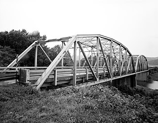
The Lee Creek Bridge in Natural Dam, Arkansas is a Pennsylvania through-truss bridge that was built in 1934. It is a twin-span bridge with a total length of 587 feet (179 m), which carries Arkansas Highway 59 across Lee Creek. It rests on concrete piers and abutments, has a vertical clearance of 14 feet (4.3 m) and has a roadbed 22 feet (6.7 m) wide.
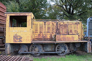
Maumelle Ordnance Works Locomotive 1 is a gasoline-powered, mechanically driven, two-axle railway locomotive which was built in 1942 by Vulcan Iron Works for the United States War Department's Maumelle Ordnance Works. It was added to the U.S. National Register of Historic Places in 2006 and is preserved at the Fort Smith Trolley Museum.

The Old Benton—Sardis Road Bridge is a historic bridge off Arkansas Highway 183 in Bauxite, Arkansas. It is a concrete deck truss bridge, with a span of about 15 feet (4.6 m), and is oriented east-west along an old road bed, resting on concrete abutments with diagonal wing walls. The bridge was built in 1919 as part of a project to build a new road connecting Benton to Sardis, which would facilitate the transport of bauxite mined in the area. Unlike other concrete bridges built at that time, this bridge included fieldstone in its guardrails, which provided a decorative aspect as well as perhaps being inexpensive locally. The method of contracting and construction of the road and bridge, involving the establishment of a road improvement district, was an important advance in the means by which roads were built in Arkansas.
The Southwestern Proving Ground Building No. 5 is an ammunition storage bunker at 259 Hempstead County Road 279 in Oakhaven, Arkansas, northwest of the city of Hope. It is located on property that was once part of the Southwestern Proving Ground, a major military facility during World War II whose largest portion was transformed into Hope Municipal Airport. Building No. 5 is a single-story concrete structure with a rounded roof, covered in earth, and with a heavy steel door facing northwest. It is one of three ammunition bunkers built on the proving ground. The building is used as storage by a private owner.
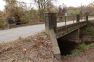
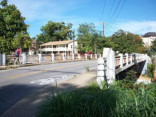
The North Washington Street Bridge is a historic bridge in DeWitt, Arkansas. Built in 1910, it carries North Washington Street over Holt Branch, just south of Holt Lane, and is the oldest known concrete bridge span in the state. It consists of two spans of steel girders, resting on concrete abutments and a concrete central pier, with concrete decking. It is 40 feet (12 m) long and has a roadbed 15 feet (4.6 m) wide. Its guard rails consist of metal piping mounted on concrete piers with simple recessed panels as a decorative effect. The short spans of the bridge demonstrate the unfamiliarity with the use of concrete as a bridge-building material.
The Marr's Creek Bridge is a historic bridge spanning Marr's Creek in Pocahontas, Arkansas. The concrete Open spandrel deck arch bridge formerly carried U.S. Route 67 (US 67), which now passes over the creek on an adjacent modern steel and concrete structure. When built in 1934 by the Public Works Administration, the bridge had a total length of 135 feet (41 m), with six spans, including the main arch across the creek. The bridge was widened slightly at its eastern end in 1950 to accommodate a slight curve.
The Coop Creek Bridge is a historic bridge in Sebastian County, Arkansas, just outside the city of Mansfield. It carries Broadway, designated County Route 62, across Coop Creek just north of Mansfield Lake. It is a two-span open masonry structure, with one span of 18 feet (5.5 m) and one of 21 feet (6.4 m), with a total structure length of 44 feet (13 m). The bridge is set on masonry abutments and piers, with a reinforced concrete deck that is lined by simple concrete railings. It is a well-preserved example of a masonry bridge built in 1940.

The Sebastian County Road 4G Bridge is a historic bridge in rural Sebastian County, Arkansas. The bridge carries County Road 4 across an unnamed creek southwest of Hartford, between County Roads 1 and 243. It has two spans with a total length of 44 feet (13 m). Its abutments, pier, and decking are all made of concrete, and it has simple concrete railings on the sides. Built in 1940, it is a well-preserved example of a concrete bridge from that period.
The Lafayette Street Overpass is a historic bridge in Fayetteville, Arkansas. It is a three-span open masonry structure, carrying Lafayette Street over the tracks of the St. Louis–San Francisco Railway. The bridge is about 120 feet (37 m) long and 30 feet (9.1 m) wide, and consists of reinforced concrete spans resting on concrete abutments. It features an Art Deco railing, with a metal balustrade covering concrete piers with inset light fixtures. The bridge was built in 1938 by Ed B. Mooney, Inc.

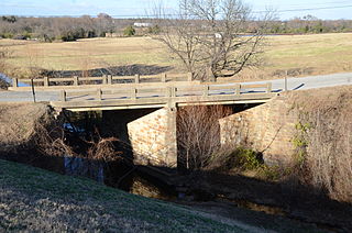
The Hackett Creek Bridge is a historic bridge near Hackett, Arkansas, which carries Arkansas Highway 45 across Hackett Creek. The bridge is a three-span concrete structure set on abutments and piers of stone and concrete. The longest single span is 36 feet (11 m) long, and the total bridge length is 98 feet (30 m). The deck is asphalt laid over concrete, and there are simple concrete railings on either side. Built in 1941, it is a well-preserved concrete bridge of the period.

The Arkansas Ordnance Plant Guard House is a historic military structure on the grounds of the Jacksonville Museum of Military History in Jacksonville, Arkansas. It is a square wood-frame structure measuring 9 by 9 by 12 feet, mounted on metal skids for ease of relocation. It is presently mounted on a concrete pad to the right of the main museum building, believed to be not far from its original location. It was built in 1941 as part of the facilities of the World War II-era Arkansas Ordnance Plant, a facility that produced fuses and detonators in Jacksonville. After the war it was moved to 1112 MacArthur Drive, and it was moved to the museum in 2006.

The Miller Creek Bridge is a historic bridge, carrying Millers Creek Road across Millers Creek, just north of the city limits of Batesville, Arkansas. Built in 1914, it is the state's oldest surviving concrete bridge. It is a two-span arched structure with a total length of 123 feet (37 m), and a width of 12 feet (3.7 m), carrying a single lane of traffic. The bridge is somewhat overengineered, as the use of concrete in bridge construction was then relatively new, and knowledge of the material's properties in this application was not well understood.

The Pyeatte-Mason Cemetery is a small historic cemetery at the junction of Waterside and Lily Streets on the west side of Maumelle, Arkansas. It occupies a small wooded lot, and has ten marked graves. It contains graves of some of Pulaski County's earliest settlers, the Pyeatte and Carnahan families. They settled this area in 1812, calling it Crystal Hill. The only dated graves in the cemetery are marked 1818 and 1883. They were led by the brothers James Pyeatt, a farmer, and Jacob Pyeatt, who operated a ferry on the Arkansas River. The first Protestant services held in Arkansas were conducted in 1812 in the home of James Pyeatt by the Reverend John Carnahan of the Cumberland Presbyterian Church. The original settlement, called Pyeattstown, grew to 150 people by 1819. Pyeatte township was formed in 1823. James Pyeatt died in 1833 and was buried near his land in a small cemetery that is now near the Maumelle Country Club's golf course. The township of Maumelle was formed in 1842. It was composed of two sections: Little Maumelle and Big Maumelle.

The Van Buren County Road 2E Bridge is a historic bridge in rural southwestern Van Buren County, Arkansas. It is a three-span open concrete masonry structure, with each span measuring 12 feet (3.7 m) in length, carrying County Road 2E across an unnamed tributary of Driver's Creek. The bridge rests on piers and abutments of stone and concrete, and has a roadway deck 19.9 feet (6.1 m) wide. It was built in 1940 with funding from the Works Progress Administration, and is a well-preserved example of a period concrete bridge.

The Brinkley Concrete Streets are several road sections in Brinkley, Arkansas. They include one block of Ash Street, and several on New York Street. These roads are two lanes wide, and were built in 1928-29 out of concrete sections 14 feet (4.3 m) wide and about 24 feet (7.3 m). They were among the first 4 miles (6.4 km) of city streets to be paved, and followed the practice of the nearby Bankhead Highway sections, which were also built in concrete.


