Cloudcroft is a village in Otero County, New Mexico, United States, and is located within the Lincoln National Forest. The population was 674 at the 2010 census. Despite being located in an otherwise arid region, its high elevation (8,676 feet allows for a mild summer and forested surroundings that makes it a popular tourist attraction in west Texas and southern New Mexico. It was named by Fodor's in 2002 as the Number 3 "Most Overlooked and Underrated Destination Spot." Tourism remains the primary economic driver of the village.

La Luz is a census-designated place (CDP) in Otero County, New Mexico, United States. The population was 1,615 at the 2000 census. It is located immediately north of Alamogordo and lies in the eastern edge of the Tularosa Basin and on the western flank of the Sacramento Mountains. Until 1848, La Luz was a part of Mexico. The CDP gets its name from the Spanish word for "light."

Timberon is a census-designated place (CDP) in Otero County, New Mexico, United States, and is within the Sacramento Mountains at the southern edge of the Lincoln National Forest. The population was 309 at the 2000 census.

The Kettle Valley Railway was a subsidiary of the Canadian Pacific Railway (CPR) that operated across southern British Columbia, west of Midway running to Rock Creek, then north to Myra Canyon, down to Penticton over to Princeton, Coalmont, Brookmere, Coquihalla and finally Hope where it connected to the main CPR line.

A trestle bridge is a bridge composed of a number of short spans supported by closely spaced frames. A trestle is a rigid frame used as a support, historically a tripod used to support a stool or a pair of isosceles triangles joined at their apices by a plank or beam such as the support structure for a trestle table. Each supporting frame is a bent. A trestle differs from a viaduct in that viaducts have towers that support much longer spans and typically have a higher elevation.

The Mount Lowe Railway was the third in a series of scenic mountain railroads in the United States created as a tourist attraction on Echo Mountain and Mount Lowe, north of Los Angeles, California. The railway, originally incorporated by Thaddeus S. C. Lowe as the Pasadena and Mt. Wilson Railroad Co., existed from 1893 until its official abandonment in 1938, and was the only scenic mountain, electric traction railroad ever built in the United States. Lowe's partner and engineer was David J. Macpherson, a civil engineer graduate of Cornell University. The Mount Lowe Railway was a fulfillment of 19th century Pasadenans' desire to have a scenic mountain railroad to the crest of the San Gabriel Mountains.
The Niles Canyon Railway (NCRy) is a heritage railway running on the first transcontinental railroad alignment through Niles Canyon, between Sunol and the Niles district of Fremont in the East Bay of the San Francisco Bay Area, in California, United States. The railway is listed on the National Register of Historic Places as the Niles Canyon Transcontinental Railroad Historic District. The railroad is operated and maintained by the Pacific Locomotive Association which preserves, restores and operates historic railroad equipment. The NCRy features public excursions with both steam and diesel locomotives along a well-preserved portion of the first transcontinental railroad.

The Sacramento Northern Railway was a 183-mile (295 km) electric interurban railway that connected Chico in northern California with Oakland via the California capital, Sacramento. In its operation it ran directly on the streets of Oakland, Sacramento, Yuba City, Chico, and Woodland and ran interurban passenger service until 1941 and freight service into the 1960s.

Lincoln National Forest is a unit of the U.S. Forest Service located in southern New Mexico. The Lincoln National Forest covers an extensive 1.1 million acres in southeastern New Mexico. Established by Presidential Proclamation in 1902 as the Lincoln Forest Reserve, the 1,103,897 acres (4,467.31 km2) forest begins near the Texas border and contains lands in parts of Chaves, Eddy, Lincoln, and Otero counties. The Lincoln National Forest is home to three major mountain ranges: Sacramento, Guadalupe and Capitan. The three Ranger Districts within the forest contain all or part of a total of four mountain ranges, and include a variety of different environmental areas, from desert to heavily forested mountains and sub-alpine grasslands. Clean air, water, and soil are necessary elements that the National Forests contribute to the environment. Established to balance conservation, resource management, and recreation, the lands of the Lincoln National Forest include important local timber resources, protected wilderness areas, and popular recreation and winter sports areas. The forest headquarters is located in Alamogordo, N.M. with local offices in Carlsbad, Cloudcroft, and Ruidoso.

High Rolls is an unincorporated community and census-designated place in Otero County, New Mexico, United States. It is nestled within the Lincoln National Forest at the southernmost tip of the Sacramento Mountains.

The 650-foot (200 m) Dale Creek Crossing, completed in 1868 in the southeastern Wyoming Territory, presented engineers of the United States' first transcontinental railroad one of their most difficult challenges. Dale Creek Bridge, the longest bridge on the Union Pacific Railroad (UP), reached 150 feet (46 m) above Dale Creek, two miles (3.2 km) west of Sherman, Wyoming. The first Dale Creek Bridge was a wooden structure 720 feet in length. The eastern approach to the bridge site, near the highest elevation on the UP, 8,247 feet (2,514 m) above sea level, required cutting through granite for nearly a mile. Solid rock also confronted workers on the west side of the bridge where they made a cut one mile (1.6 km) in length.
The El Paso and Northeastern Railway (EP&NE) was a short line railroad that was built around the beginning of the twentieth century to help connect the industrial and commercial center at El Paso, Texas, with physical resources and the United States' national transportation hub in Chicago. Founded by Charles Eddy, the EP&NE was the primary railroad in a system organized under the New Mexico Railway and Coal Company (NMRy&CCo), a holding company which owned several other railroads and also owned mining and industrial properties served by the lines.
The Alamogordo and Sacramento Mountain Railway was built as a branch line for the El Paso and Northeastern Railway (EP&NE). Construction began from the EP&NE connection at Alamogordo, New Mexico, in 1898 to reach the Sacramento Mountain fir and spruce forests to the east. Sawmills were built in Alamogordo to mill lumber for extension of the EP&NE to reach the Chicago, Rock Island and Pacific Railroad. The railroad reached Cloudcroft, New Mexico, in 1900, where a lodge was built for summer tourists to enjoy the cool mountain air. Cloudcroft was laid out in several villages so tourists might avoid associating too closely with loggers and railway workers. The railway was extended from Cloudcroft to the small community of Russia, New Mexico, in 1903; and several branches were built to reach timber for the Alamogordo Lumber Company.

U.S. Route 82 (US 82) is a part of the U.S. Highway System that travels from Alamogordo, New Mexico, east to Brunswick, Georgia. In the U.S. state of New Mexico, US 82 extends from La Luz and ends at the Texas state line northeast of Lovington.

The Santa Fe Arroyo Seco Railroad Bridge in Highland Park, Los Angeles, is more than 710 feet (220 m) long and crosses the Arroyo Seco Parkway at an elevation of over 56 feet (17 m). It is the tallest and longest railroad span in the city of Los Angeles, and most likely the oldest such structure still in use. The bridge crosses the lower part of the Arroyo Seco, a watershed canyon from the San Gabriel Mountains.
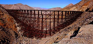
Goat Canyon Trestle is a wooden trestle in San Diego County, California. At a length of 597–750 feet (182–229 m), it is the world's largest all-wood trestle. Goat Canyon Trestle was built in 1933 as part of the San Diego and Arizona Eastern Railway, after one of the many tunnels through the Carrizo Gorge collapsed. The railway had been called the "impossible railroad" upon its 1919 completion. It ran through Baja California and eastern San Diego County before ending in Imperial Valley. The trestle was made of wood, rather than metal, due to temperature fluctuations in the Carrizo Gorge. By 2008, most rail traffic stopped using the trestle.
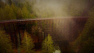
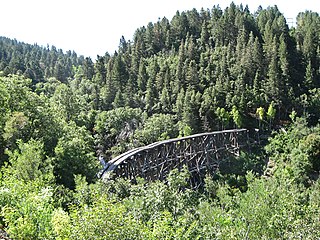
Bridge A 249 is a historic wooden trestle bridge in New Mexico's Sacramento Mountains, Otero County, New Mexico, just outside Cloudcroft, New Mexico. It was listed on the National Register of Historic Places in 2015 as Bridge A 249-Cloudcroft, New Mexico.

The Third Street Railroad Trestle is a historic wooden railroad trestle bridge crossing Shoal Creek in downtown Austin, Texas. Built around 1922 by the International–Great Northern Railroad, it replaced an earlier bridge in the same place. The bridge was used by the I–GN Railroad, the Missouri Pacific Railroad, and the Missouri–Kansas–Texas Railroad until 1964, when commercial rail traffic stopped; after 1991 the bridge was abandoned. It was added to the National Register of Historic Places in 2021.