
The Illinois and Michigan Canal connected the Great Lakes to the Mississippi River and the Gulf of Mexico. In Illinois, it ran 96 miles (154 km) from the Chicago River in Bridgeport, Chicago to the Illinois River at LaSalle-Peru. The canal crossed the Chicago Portage, and helped establish Chicago as the transportation hub of the United States, before the railroad era. It was opened in 1848. Its function was largely replaced by the wider and shorter Chicago Sanitary and Ship Canal in 1900, and it ceased transportation operations with the completion of the Illinois Waterway in 1933.

The Delaware and Raritan Canal is a canal in central New Jersey, United States, built in the 1830s, that served to connect the Delaware River to the Raritan River. It was an efficient and reliable means of transportation of freight between Philadelphia and New York City, especially coal from the anthracite fields in eastern Pennsylvania. The canal allowed shippers to cut many miles off the existing route from the Pennsylvania coal fields, down the Delaware, around Cape May, and up along the Atlantic Ocean coast to New York City.
The Morris Canal (1829–1924) was a 107-mile (172 km) common carrier coal canal across northern New Jersey in the United States that connected the two industrial canals at Easton, Pennsylvania, across the Delaware River from its western terminus at Phillipsburg, New Jersey, to New York Harbor and the New York City markets via its eastern terminals in Newark and on the Hudson River in Jersey City, New Jersey.

The Allegheny Portage Railroad was the first railroad constructed through the Allegheny Mountains in central Pennsylvania, United States; it operated from 1834 to 1854 as the first transportation infrastructure through the gaps of the Allegheny that connected the midwest to the eastern seaboard across the barrier range of the Allegheny Front. Approximately 36 miles (58 km) long overall, both ends connected to the Pennsylvania Canal, and the system was primarily used as a portage railway, haulting river boats and barges over the divide between the Ohio and the Susquehanna Rivers. Today, the remains of the railroad are preserved within the Allegheny Portage Railroad National Historic Site operated by the National Park Service.

Starved Rock State Park is a state park in the U.S. state of Illinois, characterized by the many canyons within its 2,630 acres (1,064 ha). Located just southeast of the village of Utica, in Deer Park Township, LaSalle County, Illinois, along the south bank of the Illinois River, the park hosts over two million visitors annually, the most for any Illinois state park.

The Chesapeake and Ohio Canal National Historical Park is located in the District of Columbia and the state of Maryland. The park was established in 1961 as a National Monument by President Dwight D. Eisenhower to preserve the neglected remains of the Chesapeake and Ohio Canal and many of its original structures. The canal and towpath trail extends along the Potomac River from Georgetown, Washington, D.C., to Cumberland, Maryland, a distance of 184.5 miles (296.9 km). In 2013, the path was designated as the first section of U.S. Bicycle Route 50.

The Patowmack Canal is a series of five inoperative canals located in Maryland and Virginia, United States, that was designed to bypass rapids in the Potomac River upstream of the present Washington, D.C. area. The most well known of them is the Great Falls skirting canal, whose remains are managed by the National Park Service as it is within Great Falls Park Virginia, an integral part of the George Washington Memorial Parkway.

The Middlesex Canal was a 27-mile (44-kilometer) barge canal connecting the Merrimack River with the port of Boston. When operational it was 30 feet wide, and 3 feet deep, with 20 locks, each 80 feet long and between 10 and 11 feet wide. It also had eight aqueducts.
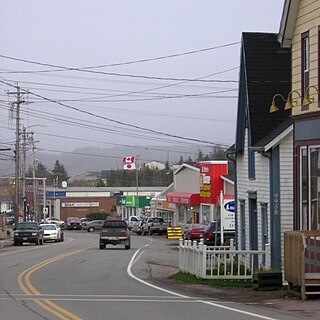
St. Peter's is a small incorporated village located on Cape Breton Island in Richmond County, Nova Scotia, Canada.

The Hennepin Canal State Trail, also just called the Hennepin Canal, is an abandoned waterway in northwest Illinois, between the Mississippi River at Rock Island and the Illinois River near Hennepin. The entire canal is listed on the National Register of Historic Places.

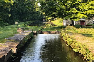
Enfield Falls Canal is a canal that was built to circumvent the shallows at Enfield Falls on the Connecticut River, between Hartford, Connecticut and Springfield, Massachusetts. It is situated along the west side of the river, adjacent to the towns of Suffield and Windsor Locks in Hartford County in the state of Connecticut, USA. Windsor Locks is named after the series of locks on the canal.
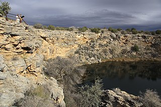
Montezuma Well, a detached unit of Montezuma Castle National Monument, is a natural limestone sinkhole near the town of Lake Montezuma, Arizona, through which some 1,500,000 US gallons of water emerge each day from an underground spring. It is located about 11 miles (18 km) northeast of Montezuma Castle.
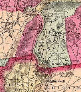
The South Hadley Canal was a canal along the Connecticut River in South Hadley, Massachusetts. It was the earliest navigable canal in the United States, with operation commencing in 1795. It has been listed on the National Register of Historic Places as the South Hadley Canal Historic District.
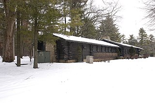
The White Pines State Park Lodge and Cabins are located in rural Ogle County, Illinois near the village of Mount Morris. They were added to the National Register of Historic Places in 1985. The Cabins are one of two Historic Places found in or near Mount Morris, the other is the Samuel M. Hitt House. The Lodge and Cabins are part of a National Register Multiple Property Submission, they were submitted with several other state park lodges, all designed by Joseph F. Booton.

The Holyoke Canal System is a system of power canals in Holyoke, Massachusetts. It is split into three canals based on elevation and distance from the inlet at the Holyoke Dam- the First Level Canal, Second Level Canal, and Third Level Canal. Constructed over a period between 1847 and 1892, the Canal System, along with the Dam, is recognized as a Historic Mechanical Engineering Landmark by the American Society of Mechanical Engineers for its use in the development of the Venturi meter by Clemens Herschel, the first means of measuring large-scale flows, and the McCormick-Holyoke Turbine by John B. McCormick, which doubled the efficiency of turbines to more than 80% in its time.
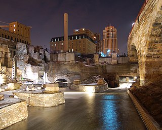
Mill Ruins Park is a park in downtown Minneapolis, Minnesota, United States, standing on the west side of Saint Anthony Falls on the Mississippi River. The park interprets the history of flour milling in Minneapolis and shows the ruins of several flour mills that were abandoned.
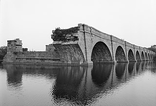
Schoharie Crossing State Historic Site, also known as Erie Canal National Historic Landmark, is a historic district that includes the ruins of the Erie Canal aqueduct over Schoharie Creek, and a 3.5-mile (5.6 km) long part of the Erie Canal, in the towns of Glen and Florida within Montgomery County, New York. It was the first part of the old canal to be designated a National Historic Landmark, prior to the designation of the entire New York State Barge Canal as a NHL in 2017.

Pueblo Grande Ruin and Irrigation Sites are pre-Columbian archaeological sites and ruins, located in Phoenix, Arizona. They include a prehistoric platform mound and irrigation canals. The City of Phoenix manages these resources as the Pueblo Grande Museum Archaeological Park.

Gaston's Mill-Lock No. 36, Sandy and Beaver Canal District, is a historic district listed in the National Register of Historic Places. The district is located within Beaver Creek State Park, approximately 1 mile south of Clarkson, Ohio. Gaston's Mill was constructed in 1837 and was powered by Little Beaver Creek. Lock 36 was one of 90 locks on the Sandy and Beaver Canal. Construction of this canal began in 1834 but was not completed until 1848.

The Morris Downtown Commercial Historic District is a historic district in downtown Morris. The district includes 116 buildings and a monument; 105 of these are commercial buildings, and 87 are contributing properties to the district.


