
Clark County is a county located in the south-central part of the U.S. state of Arkansas. As of the 2020 census, the population was 21,446. The county seat is Arkadelphia. The Arkadelphia, AR Micropolitan Statistical Area includes all of Clark County.

Historic Washington State Park is a 101-acre (41 ha) Arkansas state park in Hempstead County, Arkansas in the United States. The museum village contains a collection of pioneer artifacts from the town of Washington, Arkansas, which is a former pioneer settlement along the Southwest Trail. Walking interpretive tours are available throughout the 54 buildings. Washington served as a major trading point along the Southwest Trail, evolving into the Hempstead county seat and later the capital of Arkansas from 1863 to 1865 when Little Rock was threatened during the Civil War. The original plat of Washington was added to the National Register of Historic Places in 1972 as the Washington Historic District.

The Rohwer War Relocation Center was a World War II Japanese American concentration camp located in rural southeastern Arkansas, in Desha County. It was in operation from September 18, 1942, until November 30, 1945, and held as many as 8,475 Japanese Americans forcibly evacuated from California. The Rohwer War Relocation Center Cemetery is located here, and was declared a National Historic Landmark in 1992.
The Confederate State Capitol building in Washington, Arkansas was the capital of the Confederate state government of Arkansas, during 1863–1865, after Little Rock, Arkansas fell to Union forces in the American Civil War. It is located within Historic Washington State Park, and is a National Historic Landmark.

The Eaker site (3MS105) is an archaeological site on Eaker Air Force Base near Blytheville, Arkansas, that was declared a National Historic Landmark in 1996. The site is the largest and most intact Late Mississippian Nodena phase village site within the Central Mississippi Valley, with archaeological evidence indicating a palisaded village some 50 acres (20 ha) in size, with hundreds of structures. The site's major period of occupation was 1350–1450 CE, although evidence of occupation dates back to 600 CE. The site is also hypothesized to have been occupied by the Quapaw prior to a migration further south, after which they made contact with Europeans in the late 17th century.

The Menard–Hodges site (3AR4), is an archaeological site in Arkansas County, Arkansas. It includes two large platform mounds as well as several house mounds. It is the type site for the Menard phase, a protohistoric Mississippian culture group.

This is a list of the National Register of Historic Places listings in Washington County, Arkansas.

This is a list of the National Register of Historic Places listings in Hempstead County, Arkansas.

This is a list of the National Register of Historic Places listings in Mississippi County, Arkansas.

The Hodgen's Cemetery Mound is a Native American mound in the far eastern part of the U.S. state of Ohio. Located in the village of Tiltonsville along the Ohio River shoreline of Jefferson County, the mound is a prehistoric earthwork and archaeological site, and it has been named a historic site.
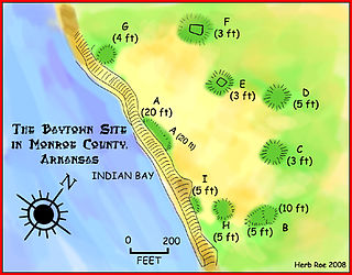
The Baytown Site is a Pre-Columbian Native American archaeological site located on the White River at Indian Bay, in Monroe County, Arkansas. It was first inhabited by peoples of the Baytown culture and later briefly by peoples of the Plum Bayou culture, in a time known as the Late Woodland period. It is considered the type site of the Baytown culture.
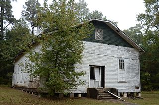
The Oak Grove Missionary Baptist Church is a historic church on Hempstead County Route 16, about 3 miles (4.8 km) south of the small town of Blevins, Arkansas. It is a single-story wood-frame structure, with a Jerkinhead roof, and a steeple topped by a hip roof. It was built in 1942, using in part materials recycled from an 1870 church which was dismantled due to the establishment of the Southwestern Proving Ground in 1940. The church serves an African-American congregation that was, prior to its relocation, in a community that was originally named for, and supported by, Arkansas Senator James Kimbrough Jones. The church property includes a small wood-frame Sunday school building, constructed about the same time as the church, and a cemetery.
The Hughes Mound Site, (3SA11), is an archeological site in Saline County, Arkansas near Benton. The 4.5-acre (1.8 ha) is an important Caddoan Mississippian culture village center, at the northeastern frontier of that civilization. It is the only known platform mound site south of Benton on the Saline River. The site has not been dated, but artifacts found there are consistent with the Caddoan period; no contact-period artifacts have been found.

Boone's Mounds are a ceremonial site of the Coles Creek culture located in Calhoun County, Arkansas. The site is one of the largest mound sites in the Ouachita River valley. Archeological excavation at the site has yielded dates of occupation as early as 600 AD, and it may still have been in use during the early contact period, c. 1700. The site was located on private property at the time of its listing on the National Register of Historic Places in 1980.
The Mound Cemetery is a historic cemetery, located just outside Arkansas City, Arkansas in Desha County. The oldest portion of the cemetery, dating to the 1860s, is located on top of a Mississippian culture mound, one of the few places the early American settlers of the area found to be safe from periodic flooding by the Mississippi River. It is located off County Road 351, about one-half mile outside Arkansas City, and about 3 miles (4.8 km) from the river.
The Ross Site designated 3CL401, is a prehistoric archaeological site in Clark County, Arkansas, near the small town of Whelen Springs. The site includes two Native American mounds from the Caddoan culture, which have been dated to AD 1400–1600. It is one of a small number of Caddoan sites in southwestern Arkansas. The site was relatively unscathed until the mid-1980s, having never been plowed over, thus leaving intact potential ground-level features other than the mounds.

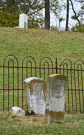
The Dooley's Ferry Fortifications Historic District encompasses a series of military earthworks erected in southwestern Arkansas, along the Red River in Hempstead County. They were constructed in late 1864 by Confederate troops under orders from Major-General John B. Magruder as a defense against the potential movements of Union Army forces toward Shreveport, Louisiana. They command a formerly major road intersection just east of Dooley's Ferry, one of the most important regional crossings of the Red River. After the war a cemetery for African-Americans was established adjacent to one of the gun emplacements.
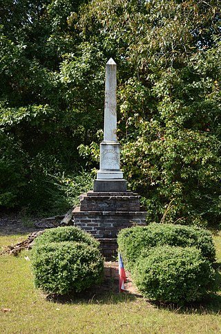
The Washington Confederate Memorial is located in the Washington Presbyterian Cemetery, off United States Route 278 on the northwest side of Washington, Arkansas. The memorial is a marble obelisk, 7'8" tall, which is mounted on a three-tiered brick base that is 4'10" tall. It marks the grave site of 74 unknown Confederate Army soldiers, many of whom were killed in the 1863 Battle of Prairie D'Ane. The monument was raised by public subscription in 1888, and underwent restorative maintenance as recently as 1994.

The Hope Historic Commercial District encompasses a two-block area of downtown Hope, Arkansas. The 18-acre (7.3 ha) district is bounded on the north by the railroad tracks, on the east by Walnut Street, the west by Elm Street, and the south by 3rd Street. The area consists for the most part of commercial brick buildings one or two stories in height, with relatively plain styling. Most of these were built between 1880 and 1945, the major period of Hope's development. The most architecturally significant buildings in the district are the Brundidge Building, an 1893 Romanesque Revival structure, and the Renaissance Revival former post office building.

