Mount Pelly

Last updated
Mount Pelly
Ovayok

Mount Pelly 1998-06-28.jpg

Mount Pelly, north of Cambridge Bay (Victoria Island)
Highest point
Elevation More than 200 m (660 ft)
Coordinates 69°10′40″N104°43′20″W / 69.17778°N 104.72222°W / 69.17778; -104.72222 Coordinates: 69°10′40″N104°43′20″W / 69.17778°N 104.72222°W / 69.17778; -104.72222
Geography
Location map Nunavut 2.png
Red triangle with thick white border.svg
Mount Pelly
Geology
Mountain type Esker

Mount Pelly or Pelly Mountain (Inuinnaqtun: Ovayok or Uvajuq) is an esker [1] in Kitikmeot, Nunavut. It is located in the Canadian North on Victoria Island within the Ovayok Territorial Park. [2] The hill, which is more than 200 m (660 ft) high, is located 15 km (9.3 mi) north east of the hamlet of Cambridge Bay, Nunavut. [2]

Inuinnaqtun indigenous Inuit language of Canada and a dialect of Inuvialuktun

Inuinnaqtun, is an indigenous Inuit language of Canada and a dialect of Inuvialuktun. It is related very closely to Inuktitut, and some scholars, such as Richard Condon, believe that Inuinnaqtun is more appropriately classified as a dialect of Inuktitut. The governments of the Northwest Territories and Nunavut recognise Inuinnaqtun as an official language in addition to Inuktitut. The Official Languages Act of Nunavut, passed by the Senate of Canada on June 11, 2009, recognized Inuinnaqtun as one of the official languages of Nunavut.

Esker Long, winding ridge of stratified sand and gravel associated with former glaciers

An esker, eskar, eschar, or os, sometimes called an asar, osar, or serpent kame, is a long, winding ridge of stratified sand and gravel, examples of which occur in glaciated and formerly glaciated regions of Europe and North America. Eskers are frequently several kilometres long and, because of their peculiar uniform shape, are somewhat like railway embankments.

Nunavut Territory of Canada

Nunavut is the newest, largest, and most northerly territory of Canada. It was separated officially from the Northwest Territories on April 1, 1999, via the Nunavut Act and the Nunavut Land Claims Agreement Act, though the boundaries had been drawn in 1993. The creation of Nunavut resulted in the first major change to Canada's political map since the incorporation of the province of Newfoundland in 1949.

Contents

History

The area around Ovayok has long been used by Inuit as a hunting area and there are over 120 archaeological sites on the esker. These include pirujaq (storage cache), campsites and a grave. The oddest find was a stack of loon bones that had been "cut at every joint". This find, which the local elders indicated was something they had never seen and must have happened before their grandparents were alive, fitted in with an Inuit legend. The legend indicated that people in the area were starving and they were saved only when a skilled hunter killed a loon. To feed all the people the bones had to be broken at the joints so all could be fed. [3]

The Inuit are a group of culturally similar indigenous peoples inhabiting the Arctic regions of Greenland, Canada, and Alaska. The Inuit languages are part of the Eskimo–Aleut family. Inuit Sign Language is a critically endangered language isolate used in Nunavut.

Archaeology, or archeology, is the study of human activity through the recovery and analysis of material culture. The archaeological record consists of artifacts, architecture, biofacts or ecofacts and cultural landscapes. Archaeology can be considered both a social science and a branch of the humanities. In North America archaeology is a sub-field of anthropology, while in Europe it is often viewed as either a discipline in its own right or a sub-field of other disciplines.

Loon genus of birds

The loons or divers are a group of aquatic birds found in many parts of North America and northern Eurasia. All living species of loons are members of the genus Gavia, family Gaviidae and order Gaviiformes.

Modern history

The esker was given its English name by Thomas Simpson and Peter Warren Dease in 1839 to honour Sir John Henry Pelly, governor of the Hudson's Bay Company. Simpson and Dease had travelled from Great Bear Lake, down the Coppermine River, to Back River. In 1850-51 John Rae, while searching the south coast of Victoria Island for clues to the lost expedition of John Franklin, climbed to the top of Mount Pelly. [3]

Thomas Simpson was an arctic explorer, Hudson's Bay Company agent and cousin of HBC governor Sir George Simpson. His violent death in what is now the state of Minnesota—allegedly by suicide after gunning down two traveling companions in the wilderness—has long been a subject of controversy.

Peter Warren Dease was a Canadian fur trader and arctic explorer.

Hudsons Bay Company Canadian retail business group

The Hudson's Bay Company is a Canadian retail business group. A fur trading business for much of its existence, HBC now owns and operates retail stores in Canada, the United States, and parts of Europe including Belgium, the Netherlands, and Germany. The company's namesake business division is Hudson's Bay, commonly referred to as The Bay. Other divisions include Galeria Kaufhof, Home Outfitters, Lord & Taylor and Saks Fifth Avenue. HBC's head office is currently located in Brampton, Ontario. The company is listed on the Toronto Stock Exchange under the symbol "HBC".

Traditional belief

Inuuhuktu (Baby Pelly) and Amaaqtuq (Lady Pelly) Inuuhuktu and Amaaqtuq.jpg
Inuuhuktu (Baby Pelly) and Amaaqtuq (Lady Pelly)

Behind Mount Pelly are two more eskers called Inuuhuktu (Baby Pelly) and Amaaqtuq (Lady Pelly). Inuit legend says that the three hills are a family of starving giants. They were crossing Victoria Island looking for food and the father, Ovayok, died first. Next the son, Inuuhuktu (English; "son" [4] ), died and was followed by the mother, Amaaqtuq (English; "packing baby", [5] see amauti), who was carrying her baby. [3]

English language West Germanic language

English is a West Germanic language that was first spoken in early medieval England and eventually became a global lingua franca. It is named after the Angles, one of the Germanic tribes that migrated to the area of Great Britain that later took their name, as England. Both names derive from Anglia, a peninsula in the Baltic Sea. The language is closely related to Frisian and Low Saxon, and its vocabulary has been significantly influenced by other Germanic languages, particularly Norse, and to a greater extent by Latin and French.

The amauti is the parka worn by Inuit women of the eastern area of Northern Canada. Up until about two years of age, the child nestles against the mother's back in the amaut, the built-in baby pouch just below the hood. The pouch is large and comfortable for the baby. The mother can bring the child from back to front for breastfeeding or for eliminatory functions without exposure to the elements. This traditional eastern Arctic Inuit parka, designed to keep the child warm and safe from frostbite, wind and cold, also helps to develop bonding between mother and child.

Related Research Articles

Inuvialuktun, also known as Western Canadian Inuit, Western Canadian Inuktitut, and Western Canadian Inuktun, comprises several Inuit language varieties spoken in the northern Northwest Territories and Nunavut by those Canadian Inuit who call themselves Inuvialuit.

Kitikmeot Region region of Nunavut

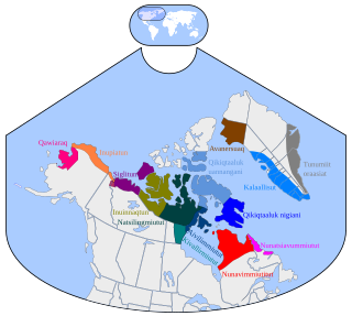
Kitikmeot Region is an administrative region of Nunavut, Canada. It consists of the southern and eastern parts of Victoria Island with the adjacent part of the mainland as far as the Boothia Peninsula, together with King William Island and the southern portion of Prince of Wales Island. The regional seat is Cambridge Bay.

Cambridge Bay Hamlet in Nunavut, Canada

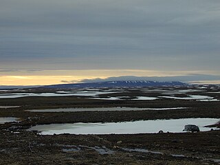
Cambridge Bay is a hamlet located on Victoria Island in the Kitikmeot Region of Nunavut, Canada. It is named for Prince Adolphus, Duke of Cambridge, while the traditional Inuinnaqtun name for the area is Ikaluktuutiak or Iqaluktuttiaq meaning "good fishing place".

Boothia Peninsula peninsula

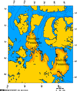
Boothia Peninsula is a large peninsula in Nunavut's northern Canadian Arctic, south of Somerset Island. The northern part, Murchison Promontory, is the northernmost point of mainland Canada.

Kangiryuarmiutun, is a dialect of Inuit language spoken in Ulukhaktok, Northwest Territories, Canada by the Kangiryuarmiut, a Copper Inuit people. The dialect is part of the Inuvialuktun language. The people of Ulukhaktok prefer to think of it as Inuinnaqtun and it is essentially the same.

Ulukhaktok Hamlet in Northwest Territories, Canada

Ulukhaktok is a small hamlet on the west coast of Victoria Island, in the Inuvik Region of the Northwest Territories, Canada.

Kugaaruk Hamlet in Nunavut, Canada

Kugaaruk, formerly known as Pelly Bay until 3 December 1999, is located on the shore of Pelly Bay, just off the Gulf of Boothia, Simpson Peninsula, Kitikmeot, in Canada's Nunavut territory. Access is by air by the Kugaaruk Airport and by annual supply sealift. Kugaaruk means "little stream", the traditional name of the brook that flows through the hamlet.

Umingmaktok Settlement in Nunavut, Canada

Umingmaktok is a now abandoned settlement located in Bathurst Inlet in the Kitikmeot Region of the Canadian territory of Nunavut. The community was previously known as Bay Chimo and the Inuit refer to the community as Umingmaktuuq.

Bathurst Inlet, Nunavut Settlement in Nunavut, Canada

Bathurst Inlet,, is a small Inuit community located in Bathurst Inlet in the Kitikmeot Region of Nunavut, Canada. As of the 2016 census the population remained at zero.

Ovayok Territorial Park territorial park in Nunavut

Ovayok Territorial Park is a park situated 15 km (9.3 mi) east of Cambridge Bay, Kitikmeot, Nunavut, Canada. The park is relatively small and covers an area of approximately 16 km2 (6.2 sq mi). The park can be accessed by vehicle from the community as a gravel road runs directly to it.

Adelaide Peninsula peninsula

Adelaide Peninsula (Iluilik), ancestral home to the Illuilirmiut Inuit, is a large peninsula in Nunavut, Canada. It is located at 68°06′N097°48′W south of King William Island. Its namesake is Queen Adelaide, consort of King William IV of the United Kingdom.

Kugluk/Bloody Falls Territorial Park territorial park in Nunavut, Canada

Kugluk/Bloody Falls Territorial Park is located about 15 kilometres (9.3 mi) southwest of Kugluktuk, Nunavut, Canada. The 10 hectares park is situated around the Bloody Falls on the Coppermine River and was listed as a national historic site in 1978.

Ferguson Lake (Kitikmeot Region) lake in Canada

Ferguson Lake is located on southern Victoria Island in the Kitikmeot Region of Nunavut, in northern Canada. It drains westward into Iqaluktuuq River which is a segment of the Ekalluk River, 5 mi (8.0 km) from the northeastern side of Wellington Bay (Ekaloktok), on Dease Strait, Arctic Ocean Ferguson Lake is the namesake of Constable Ferguson, a Royal Canadian Mounted Police member.

Copper Inuit ethnic group

Copper Inuit are a Canadian Inuit group who live north of the tree line, in what is now Nunavut's Kitikmeot Region and the Northwest Territories's Inuvik Region. Most historically lived in the area around Coronation Gulf, on Victoria Island, and southern Banks Island.

Denmark Bay is an Arctic waterway in Kitikmeot Region, Nunavut, Canada. It is located in western M'Clintock Channel, off the eastern coast of Victoria Island. It is separated from Homan Bay by a peninsula with a narrow isthmus.

Ekalluktogmiut were a geographically defined Copper Inuit subgroup in Canada's Nunavut territory. They were located along the Ekalluk River near the center of Victoria Island, Albert Edward Bay in western Victoria Strait, and Denmark Bay. According to the Arctic explorer Vilhjalmur Stefansson, the Ekalluktogmiut winter hunt on Dease Strait.

Umingmuktogmiut

The Umingmuktogmiut are a geographically defined Copper Inuit band in the northern Canadian territory of Nunavut, Kitikmeot Region. They were located on the western coast of Kent Peninsula, and also further south in eastern Bathurst Inlet around Everitt Point by the Barry Islands. Umingmuktogmiut were notable amongst other Copper Inuit as they had a permanent community, Umingmuktog. They could hunt and fish for Arctic char, Arctic fox, barren-ground caribou, fur seals, and muskox prevalent in the area.

The Ekalluk River is a river in Kitikmeot Region, Nunavut, Canada. It is located in central through southeastern Victoria Island. Its source is Ferguson Lake, and it flows west to Wellington Bay and east to Albert Edward Bay. Nearby lakes include Keyhole Lake, Kitiga Lake, and Surrey Lake. The closest community is Cambridge Bay.

References

  1. Mount Pelly Territorial Park, Cambridge Bay
  2. 1 2 Nunavut Parks Archived 2011-04-08 at the Wayback Machine .
  3. 1 2 3 David F. Pelly & Kim Crockatt, ed. (1999). Uvajuq The Origin of Death. Elsie Anaginak Klengenberg (illustrator). Kitikmeot Heritage Society. ISBN   978-0-9690783-8-8.
  4. "Inuuhuktu". Asuilaak Living Dictionary. Retrieved 2009-05-24.
  5. Ohokak, G.; Kadlun, M.; Harnum, B. Inuinnaqtun-English Dictionary. Kitikmeot Heritage Society.