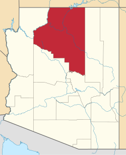
Mountainaire, Arizona | |
---|---|
Coordinates: 35°05′30″N111°38′57″W / 35.09167°N 111.64917°W | |
Country | United States |
State | Arizona |
County | Coconino |
Area | |
• Total | 10.21 sq mi (26.43 km2) |
• Land | 10.20 sq mi (26.43 km2) |
• Water | 0.00 sq mi (0.01 km2) |
Elevation | 6,952 ft (2,119 m) |
Population (2020) | |
• Total | 1,068 |
• Density | 104.66/sq mi (40.41/km2) |
Time zone | UTC-7 (MST) |
ZIP code | 86005 |
Area code | 928 |
FIPS code | 04-47820 |
GNIS feature ID | 2408886 [2] |
Mountainaire is a census-designated place (CDP) in Coconino County, Arizona, United States. The population was 1,119 at the 2010 census. [3]
According to the United States Census Bureau, the CDP has a total area of 10.2 square miles (26.5 km2), all land.
Mountainaire CDP includes Kachina Hills and Mountainaire subdivisions, and nearby areas. [4]
This region experiences warm (but not hot) and dry summers, with no average monthly temperatures above 71.6 °F. According to the Köppen Climate Classification system, Mountainaire has a warm-summer Mediterranean climate, abbreviated "Csb" on climate maps. [5]
Census | Pop. | Note | %± |
---|---|---|---|
2020 | 1,068 | — | |
U.S. Decennial Census [6] |
As of the census [7] of 2000, there were 1,014 people, 417 households, and 246 families living in the CDP. The population density was 99.2 inhabitants per square mile (38.3/km2). There were 556 housing units at an average density of 54.4 per square mile (21.0/km2). The racial makeup of the CDP was 86.1% White, 0.3% Black or African American, 7.7% Native American, 0.3% Asian, 0.1% Pacific Islander, 3.1% from other races, and 2.5% from two or more races. 6.6% of the population were Hispanic or Latino of any race.
There were 417 households, out of which 31.4% had children under the age of 18 living with them, 46.8% were married couples living together, 8.2% had a female householder with no husband present, and 41.0% were non-families. 26.6% of all households were made up of individuals, and 4.1% had someone living alone who was 65 years of age or older. The average household size was 2.43 and the average family size was 3.04.
In the CDP, the age distribution of the population shows 24.7% under the age of 18, 8.5% from 18 to 24, 39.6% from 25 to 44, 23.5% from 45 to 64, and 3.7% who were 65 years of age or older. The median age was 33 years. For every 100 females, there were 110.4 males. For every 100 females age 18 and over, there were 107.6 males.
The median income for a household in the CDP was $41,250, and the median income for a family was $49,355. Males had a median income of $32,406 versus $27,125 for females. The per capita income for the CDP was $23,625. About 5.3% of families and 7.4% of the population were below the poverty line, including 10.9% of those under age 18 and none of those age 65 or over.
Mountainaire is within the Flagstaff Unified School District. [8] The zoned secondary schools are Mount Elden Middle School and Flagstaff High School. [9]
Coconino County is a county in the North-Central part of the U.S. state of Arizona. Its population was 145,101 at the 2020 census. The county seat is Flagstaff. The county takes its name from Cohonino, a name applied to the Havasupai people. It is the second-largest county by area in the contiguous United States, behind San Bernardino County, California. It has 18,661 sq mi (48,300 km2), or 16.4% of Arizona's total area, and is larger than the nine smallest states in the U.S.
Lukachukai is a census-designated place (CDP) in Apache County, Arizona, United States. The population was 1,701 at the 2010 census. It is within the Navajo Nation.
Teec Nos Pos is a census-designated place (CDP) in Apache County, Arizona, United States. The population was 507 at the 2020 census. It is the western terminus of U.S. Route 64.
Bitter Springs is a native village and census-designated place (CDP) on the Navajo Nation in Coconino County, Arizona, United States. As of the 2020 census, the CDP population was 364
Cameron is a census-designated place (CDP) in Coconino County, Arizona, United States, on the Navajo Nation. The population was 885 at the 2010 census. Most of the town's economy is tourist food and craft stalls, restaurants, and other services for north–south traffic from Flagstaff and Page. There is a ranger station supplying information and hiking permits for the Navajo Nation. There is also a large craft store run by the Nation itself. It is named after Ralph H. Cameron, Arizona's first senator.
Kachina Village is a census-designated place (CDP) in Coconino County, Arizona, United States. The population was 2,622 at the 2010 census. Kachina Village is primarily a bedroom community for Flagstaff.
Kaibeto is a census-designated place (CDP) in Coconino County, Arizona, United States. The population was 1,522 at the 2010 census.
LeChee is a census-designated place (CDP) in Coconino County, Arizona, United States. The population was 1,443 at the 2010 census.
LeuppLOOP is a census-designated place (CDP) in Coconino County, Arizona, on the Navajo Nation, United States. The population was 951 at the 2010 census.
Moenkopi is a census-designated place (CDP) in Coconino County, Arizona, United States, adjacent to the southeast side of Tuba City off U.S. Route 160. The population was 964 at the 2010 census.
Munds Park is an unincorporated census-designated place (CDP) in Coconino County, Arizona, United States. The year round population was 631 at the 2010 census.
Parks is a census-designated place (CDP) in Coconino County, Arizona, United States. The population was 1,188 at the 2010 census.
Tonalea is a census-designated place (CDP) in Coconino County, Arizona, United States. The population was 549 at the 2010 census. It has also been known as Red Lake.
Tuba City is an unincorporated town and census-designated place in Coconino County, Arizona, on the Navajo Nation, United States. It is the second-largest community in Coconino County. The population of the census-designated place (CDP) was 8,611 at the 2010 census.
Tusayan is a town located in Coconino County, Arizona, United States. It was incorporated in 2010. A resort town near the south entrance to Grand Canyon National Park. The population was 558 at the 2010 census.
Winslow West is a census-designated place (CDP) in Navajo and Coconino counties in Arizona, United States. The population was 438 at the 2010 census. The entire community is off-reservation trust land belonging to the Hopi Tribe of Arizona. It lies just west of the city of Winslow, and is more than 50 km (31 mi) south of the main Hopi Reservation.
Strawberry is an unincorporated community and census-designated place (CDP) in Gila County, Arizona, United States. The population was 961 at the 2010 census.
Bagdad is a copper mining community and census-designated place (CDP) in Yavapai County, Arizona, United States, in the western part of the state. It is one of only two remaining company towns in Arizona. The population was 1,876 at the 2010 census, up from 1,578 in 2000.
Village of Oak Creek is an unincorporated community located within Big Park a census-designated place (CDP) in Yavapai County, Arizona, United States. The population was 6,147 at the 2010 census, up from 5,245 in 2000. Big Park is the name of the CDP while the community is more commonly known as the Village of Oak Creek (VOC), and is a bedroom community for Sedona, located seven miles away. Tourism and service to retirees and second-home owners are the basis for the local economy. Big Park, the pioneers' name for the large open area that became the Village of Oak Creek in the early 1960s, is set among scenic red-rock buttes and canyons. The Bell Rock scenic area adjoins the north end of VOC, and the town is surrounded by the Coconino National Forest. A Forest Service Visitor Center is located at the south end of VOC.
Congress is a census-designated place (CDP) in Yavapai County, Arizona, United States. Once a gold-mining center for the Congress Mine and then a ghost town, Congress now serves as a retirement and bedroom community for nearby Wickenburg. The population was 1,811 at the 2020 census.