Noank is a village and census-designated place (CDP) in the town of Groton, Connecticut. The original settlement is along Elm Street and east of it towards Morgan Point, and is listed as a historic district on the National Register of Historic Places. The population was 1,796 at the 2010 census.
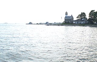
Morgan Point Lighthouse is a lighthouse in Noank, Connecticut, United States, on the west side of the mouth of the Mystic River.

The Church of the Holy Trinity is an historic Episcopal church at 381 Main Street in Middletown, Connecticut. Completed in 1874, it is one of the city's finest examples of Gothic Revival architecture. Its nearby former rectory, also known as the Bishop Acheson House, is one of its finest Colonial Revival houses. The two buildings were listed on the National Register of Historic Places in 1979.

As of 2007 there are five church buildings in the Sycamore Historic District, located in Sycamore, Illinois, United States which are listed as contributing properties to the district. The Sycamore Historic District was added to the U.S. National Register of Historic Places on May 2, 1978. When it was nominated to join the National Register there were seven church buildings within the district. One of those included is a residential structure that was utilized as a church when it was first constructed; the Arthur Stark House was once home to the Sycamore Universalist Church congregation. In the time since its listing, two churches have been destroyed or demolished. The Evangelical Church of St. John was destroyed by fire in 2004 and the United Methodist Church in Sycamore is no longer extant, replaced by a modern office building.

The Black Rock Historic District is a predominantly residential historic district in the Black Rock section of Bridgeport, Connecticut. It was listed on the National Register of Historic Places in 1979. At that time it included 109 contributing buildings. The historic district surrounds at the upper reaches of Black Rock Harbor.

Broad Street – Davis Park Historic District is a historic district in the borough of Danielson, in the town of Killingly, Connecticut. The district is mainly residential in character, and includes Davis Park, a 1.9-acre (0.77 ha) triangular park created in 1890 and bounded by Main, Reynolds, and Broad Streets. The district as a whole is 30 acres (12 ha) in size. It includes examples of Stick/Eastlake, Queen Anne, and Colonial Revival architectural styles and was added to the National Register of Historic Places in 1998. It includes 95 contributing buildings, one contributing site, and four contributing objects.
The Oswegatchie Historic District is a historic district in the town of Waterford, Connecticut, United States. The historic district is located on a peninsula on the east side of the tidal Niantic River, and represents a cross-section of historic coastal land uses, from farming to a small colony of summer estates to year-round living. The district was listed on the National Register of Historic Places in 2005.

The South Glastonbury Historic District is a historic district in Glastonbury, Connecticut. It encompasses the historic village center of South Glastonbury, which was first settled in the 17th century. The district was listed on the National Register of Historic Places in 1984, and enlarged in 2009 to include properties further along Main Street as far as Chestnut Hill Road. Locals refer to it as Nayaug.

The Tariffville Historic District is a 93 acres (38 ha) historic district in the town of Simsbury, Connecticut. It was listed on the National Register of Historic Places in 1993. It is part of the Tariffville section of Simsbury. The district includes 165 contributing buildings and two contributing sites. It also includes 26 non-contributing buildings and 4 non-contributing sites. There are several houses in the district of Gothic Revival style, probably following designs from pattern books of architect Andrew Jackson Downing. The Trinity Episcopal Church is the only building in the district designed by an architect of national standing, namely Henry C. Dudley. Many of the homes in the area were built by the Tariff Manufacturing Company, which opened a carpet mill along the Farmington River, and needed housing for workers.

The Hatfield Center Historic District encompasses the traditional center of Hatfield, Massachusetts. The area, first laid out in 1661, is bounded by Maple Street to the south, the Connecticut River to the east, Day Avenue and School Street to the north, and the Mill River to the west. The area's layout and land use patterns are relatively little altered since they were laid out, leaving a well-preserved early colonial village landscape. The district was added to the National Register of Historic Places in 1994.

The Elm Street Congregational Church is a historic church at 61 Elm Street in Southbridge, Massachusetts. Built in 1885, it is a high quality local example of high Victorian Gothic Revival architecture executed in brick. It was added to the National Register of Historic Places in 1989. The congregation, founded in 1816, is affiliated with the United Church of Christ.

The Downtown North Historic District is a 19-acre (7.7 ha) historic district in Hartford, Connecticut. It is a predominantly residential area located around Main Street and High Street north of I-84 and south of the Amtrak railroad tracks. Its apartment blocks, houses, schools and churches, built up mainly in the late 19th and early 20th centuries as part of an expansion of the city's urban core. It includes the 130-foot (40 m) Keney Tower. The area was listed on the National Register of Historic Places in 2004.

The Dwight Street Historic District is an irregularly shaped 135-acre (55 ha) historic district in New Haven, Connecticut. The district is located immediately west of the center of Downtown New Haven and is generally bounded by Elm Street on the north, Park Street on the east, North Frontage Road on the south, and Sherman Avenue on the west. It contains one of the city's highest concentrations of well-preserved 19th and early 20th-century residential architecture, much of which was developed for the working classes in the city's factories. It was listed on the National Register of Historic Places in 1983. The historic district includes most of the Dwight neighborhood and several blocks of the northeast corner of the West River neighborhood.

Norwichtown is a historic neighborhood in the city of Norwich, Connecticut. It is generally the area immediately north of the Yantic River between I-395 and Route 169.

The Metropolitan African Methodist Episcopal Zion Church is a historic Methodist Episcopal Church at 2051 Main Street in Hartford, Connecticut. This High Victorian Gothic structure was built in 1873-74 for an Episcopal congregation, and has since 1926 been the home to the city's oldest African-American congregation, which was established in 1833. The church was listed on the National Register of Historic Places in 1994.

The Greenwich Avenue Historic District is a historic district representing the commercial and civic historical development of the downtown area of the town of Greenwich, Connecticut. The district was listed on the National Register of Historic Places on August 31, 1989. Included in the district is the Greenwich Municipal Center Historic District, which was listed on the National Register the year before for the classical revival style municipal buildings in the core of Downtown. Most of the commercial buildings in the district fall into three broad styles, reflecting the period in which they were built: Italianate, Georgian Revival, and Commercial style. The district is linear and runs north-south along the entire length of Greenwich Avenue, the main thoroughfare of Downtown Greenwich, between U.S. Route 1 and the New Haven Line railroad tracks.

The Old Saybrook South Green is a 20-acre (8.1 ha) historic district that encompasses the historic town green and nearby streets in Old Saybrook, Connecticut. Established in the 1630s, most of the buildings arrayed around the green were built between 1760 and 1900, and reflect the prosperity of the town, which was a major port and shipbuilding center. The district was listed on the National Register of Historic Places in 1976.

The Longwood Historic District is roughly bounded by Chapel, St. Marys, Monmouth, and Kent Sts. in Brookline, Massachusetts. The area was developed in the mid-19th century by David Sears and Amos Adams Lawrence as a fashionable residential area, and retains a number of architecturally distinguished buildings, including the Longwood Towers complex at 20 Chapel Street, Christ's Church Longwood, and Church of Our Saviour, Brookline. The district was listed on the National Register of Historic Places on September 13, 1978.

The Randolph Center Historic District encompasses the historic early town center of Randolph, Vermont. Established in 1783, it was later eclipsed by Randolph Village, which developed around the town's main railroad depot. The village now has a distinguished array of late 18th and early 19th-century architecture, and is home to an academic campus now housing the Vermont Technical College. It was listed on the National Register of Historic Places in 1974.

The River Ledge Historic District is a primarily residential historic district located along Jefferson, Scott, and Lincoln Streets between Franklin and Maple Streets in Grand Ledge, Michigan. It was listed on the National Register of Historic Places in 1987.