
Actun Tunichil Muknal, also known locally as ATM, is a cave in Belize, near San Ignacio, Cayo District, notable as a Maya archaeological site that includes skeletons, ceramics, and stoneware. There are several areas with skeletal remains in the main chamber. The best known is "The Crystal Maiden", the skeleton of an adolescent, possibly a sacrifice victim, whose bones have been calcified to a sparkling, crystallized appearance.

Sistema Nohoch Nah Chich, is located 16.5 kilometers (10.3 mi) south of Akumal in Tulum Municipality of Quintana Roo state, southeastern Mexico. It is part of the Sistema Sac Actun and Sistema Dos Ojos group of underwater cave systems.
The flora of Belize is highly diverse by regional standards, given the country's small geographical extent. Situated on the Caribbean coast of northern Central America the flora and vegetation have been intimately intertwined with Belize's history. The nation itself grew out of British timber extraction activities from the 17th century onwards, at first for logwood and later for mahogany, fondly called "red gold" because of its high cost and was much sought after by European aristocracy. Central America generally is thought to have gained much of it characteristic flora during the "Great American interchange" during which time South American elements migrated north after the geological closure of the isthmus of Panama. Few Amazonian elements penetrate as far north as Belize and in species composition the forests of Belize are most similar to the forests of the Petén (Guatemala) and the Yucatán (Mexico).

Mountain Pine Ridge Forest Reserve is a nature reserve in the Cayo District of southern central Belize. It was established in 1944 to protect and manage the native Belizean pine forests. Its boundaries are poorly defined, but it is estimated to cover an area of 106,352.5 acres (430 km2), although much of the reserve has been leased.

Since declaring independence in 1981, Belize has enacted many environmental protection laws aimed at the preservation of the country's natural and cultural heritage, as well as its wealth of natural resources. These acts have established a number of different types of protected areas, with each category having its own set of regulations dictating public access, resource extraction, land use and ownership.

Cuchillas del Toa is a Biosphere Reserve in Cuba. It is located in the eastern part of the country, mostly in the Guantánamo Province and reaching to the north into the Holguín Province. Most of the reserve is established in the drainage area of the Toa River, which flows for 118 km (73 mi) to the Atlantic Ocean in Baracoa.

Chiquibul National Park is Belize's largest national park. It is 1,073 km2 (414 sq mi) in size. The park is located in Belize's Cayo District. The national park surrounds Caracol, a Mayan city. Caracol has been designated as an archaeological reserve and is not included within the park's total area. Chiquibul Forest Reserve is adjacent to the park.

Tourism in Belize has grown considerably recently, and it is now the second largest industry in the nation. Belizean Prime Minister Dean Barrow has stated his intention to use tourism to combat poverty throughout the country. The growth in tourism has positively affected the agricultural, commercial, and finance industries, as well as the construction industry. The results for Belize's tourism-driven economy have been significant, with the nation welcoming almost one million tourists in a calendar year for the first time in its history in 2012.

The natural environment, commonly referred to simply as the environment, includes all living and non-living things occurring naturally on Earth.
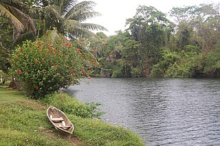
The Moho River is a river of Guatemala and Belize. The river is navigable year round between Santa Teresa and the mouth.

Bladen Nature Reserve is a landscape of caves, sinkholes, pristine streams and rivers, undisturbed old growth rainforest and an abundance of highly diverse flora and fauna which includes a great deal of rare and endemic species.

Half Moon Caye is an island and natural monument of Belize located at the southeast corner of Lighthouse Reef Atoll. This natural monument was the first nature reserve to have been established in Belize under the National Park Systems Act in 1981 and first marine protected area in Central America. This is also Belize's oldest site of wildlife protection since it was first designated as a bird sanctuary in 1924 to protect the habitat of the red-footed booby birds.
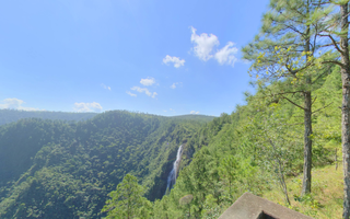
Thousand Foot Falls is a waterfall and natural monument in Cayo, Belize. It is surrounded by the Mountain Pine Ridge Forest Reserve. The Thousand Foot Falls is thought to be the highest waterfall in the Central American region. Despite what its name suggests, this massive waterfall is actually 1,600 ft tall.
Serpon Sugar Mill is an historical site in Belize, consisting of the remnants of a steam-powered sugar mill whose construction in 1865 marked the beginning of the country's industrial era. It is located near the village of Sittee River in the Stann Creek district.

Port Honduras Marine Reserve is a national protected marine reserve in the Toledo district of Belize. It was established in January 2000, and covers 40,470 hectares of mangrove and coastal ecosystems. It encompasses over one hundred small, mangrove-fringed cayes, benthic habitats comprising soft-bottom seagrass beds and fringing reefs.
The Sapodilla Cayes are an uninhabited atoll in the Gulf of Honduras. They are in the Toledo District of Belize.
South Water Caye Marine Reserve is the largest marine reserve in the Stann Creek district of Belize. It was established in 1996 and covers 47,702 hectares of mangrove and coastal ecosystems.

Gladden Spit and Silk Cayes Marine Reserve (GSSCMR) is a protected marine reserve in the central part of Belize's Barrier Reef. It covers approximately 25,980 acres (10,510 ha) lying 36 kilometres (22 mi) off the coast of Placencia. Established in 2003, The reserve comes under the authority of the government's Fisheries Department, but is managed by the Southern Environmental Association, a community-based organisation.


