Yaxuna

Last updated

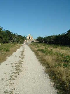
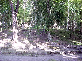
Yaxuna is a Maya archaeological site in the municipality of Yaxcabá [1] in Yucatán, Mexico.

Maya civilization Mesoamerican civilization

The Maya civilization was a Mesoamerican civilization developed by the Maya peoples, and noted for its logosyllabic script—the most sophisticated and highly developed writing system in pre-Columbian Americas—as well as for its art, architecture, mathematics, calendar, and astronomical system. The Maya civilization developed in an area that encompasses southeastern Mexico, all of Guatemala and Belize, and the western portions of Honduras and El Salvador. This region consists of the northern lowlands encompassing the Yucatán Peninsula, and the highlands of the Sierra Madre, running from the Mexican state of Chiapas, across southern Guatemala and onwards into El Salvador, and the southern lowlands of the Pacific littoral plain.

Archaeological site Place in which evidence of past activity is preserved

An archaeological site is a place in which evidence of past activity is preserved, and which has been, or may be, investigated using the discipline of archaeology and represents a part of the archaeological record. Sites may range from those with few or no remains visible above ground, to buildings and other structures still in use.

Mexico country in the southern portion of North America

Mexico, officially the United Mexican States, is a country in the southern portion of North America. It is bordered to the north by the United States; to the south and west by the Pacific Ocean; to the southeast by Guatemala, Belize, and the Caribbean Sea; and to the east by the Gulf of Mexico. Covering almost 2,000,000 square kilometres (770,000 sq mi), the nation is the fifth largest country in the Americas by total area and the 13th largest independent state in the world. With an estimated population of over 120 million people, the country is the eleventh most populous state and the most populous Spanish-speaking state in the world, while being the second most populous nation in Latin America after Brazil. Mexico is a federation comprising 31 states and Mexico City, a special federal entity that is also the capital city and its most populous city. Other metropolises in the state include Guadalajara, Monterrey, Puebla, Toluca, Tijuana and León.

The settlement had a long continuous occupation running from the Middle Formative Period through the Postclassic. The Late Formative saw the construction of a number of triadic architectural groups linked with roads running north to south. Some of the larger pyramids were remodeled during the Early Classic, and held royal tombs. In the Late Classic (ca. 600–800), the city-state of Coba conquered Yaxuna and built a 100 km Sacbe, or raised road, to connect the two cities. This was the longest the Maya ever built. [2] Internally, new roads running east to west were constructed. In the Terminal Classic (800–1100), the state of Chichén Itzá to the north began a war with the Coba state, and Yaxuna constructed a city wall, but Chichén Itzá appears to have conquered the city by around 950. Sacked and ritually destroyed, the city never recovered. By the Postclassic (1100–1697), the population was much reduced, with new construction limited to minor additions to older architecture.

Triadic pyramid

Triadic pyramids were an innovation of the Preclassic Maya civilization consisting of a dominant structure flanked by two smaller inward-facing buildings, all mounted upon a single basal platform. The largest known triadic pyramid was built at El Mirador in the Petén Basin of Guatemala; it covers an area six times as large as that covered by Tikal Temple IV, which is the largest pyramid at that city. The three superstructures all have stairways leading up from the central plaza on top of the basal platform. Triadic pyramid structures are found at early cities in the Maya lowlands.

Coba archeological site of Pre-Columbian Maya

Coba is an ancient Mayan city on the Yucatán Peninsula, located in the Mexican state of Quintana Roo. The site is the nexus of the largest network of stone causeways of the ancient Mayan world, and it contains many engraved and sculpted stelae that document ceremonial life and important events of the Late Classic Period of Mesoamerican civilization. The adjacent modern village bearing the same name, reported a population of 1,278 inhabitants in the 2010 Mexican federal census.

Related Research Articles

Chacmool type of sculpture

Chacmool is the term used to refer to a particular form of pre-Columbian Mesoamerican sculpture depicting a reclining figure with its head facing 90 degrees from the front, supporting itself on its elbows and supporting a bowl or a disk upon its stomach. These figures possibly symbolised slain warriors carrying offerings to the gods; the bowl upon the chest was used to hold sacrificial offerings, including pulque, tamales, tortillas, tobacco, turkeys, feathers and incense. In an Aztec example the receptacle is a cuauhxicalli. Chacmools were often associated with sacrificial stones or thrones.

Toltec Pre-columbian civilization

The Toltec culture is an archaeological Mesoamerican culture that dominated a state centered in Tula, Hidalgo, Mexico in the early post-classic period of Mesoamerican chronology. The later Aztec culture saw the Toltecs as their intellectual and cultural predecessors and described Toltec culture emanating from Tōllān[ˈtoːlːaːn] as the epitome of civilization; in the Nahuatl language the word Tōltēcatl[toːlˈteːkat͡ɬ] (singular) or Tōltēcah[toːlˈteːkaʔ] (plural) came to take on the meaning "artisan". The Aztec oral and pictographic tradition also described the history of the Toltec Empire, giving lists of rulers and their exploits.

Mayapan

Mayapan, , is a Pre-Columbian Maya site a couple of kilometers south of the town of Telchaquillo in Municipality of Tecoh, approximately 40 km south-east of Mérida and 100 km west of Chichen Itza; in the state of Yucatán, Mexico. Mayapan was the political and cultural capital of the Maya in the Yucatán Peninsula during the Late Post-Classic period from the 1220s until the 1440s. Estimates of the total city population are 15,000–17,000 persons, and the site has more than 4,000 structures within the city walls, and additional dwellings outside.

Flores, El Petén Place in El Petén, Guatemala

Flores is the capital of the Petén Department, Guatemala's landlocked, northernmost department. The population is 13,700 (2003).

Itza ethnic group

The Itza are a Guatemalan people of Maya affiliation. They inhabit the Petén department of Guatemala in and around the city of Flores on Lake Petén Itzá.

Sacbe

A sacbe, plural sacbeob, or "white way", is a raised paved road built by the Maya civilization of pre-Columbian Mesoamerica. Most connect temples, plazas, and groups of structures within ceremonial centers or cities, but some longer roads between cities are also known. The term "sacbe" is Yucatec Maya for "white road"; white perhaps because there is evidence that they were originally coated with limestone stucco or plaster, which was over a stone and rubble fill.

Kukulkan mythological serpent

Kukulkan is the name of a Mesoamerican serpent deity. Prior to the Spanish Conquest of the Yucatán, Kukulkan was worshipped by the Yucatec Maya peoples of the Yucatán Peninsula, in what is now Mexico. The depiction of the Feathered Serpent is present in other cultures of Mesoamerica. Kukulkan is closely related to the deity Q'uq'umatz of the K'iche' people and to Quetzalcoatl of Aztec mythology. Little is known of the mythology of this Pre-Columbian era deity.

Ek Balam

Ek' Balam is a Yucatec-Maya archaeological site within the municipality of Temozón, Yucatán, Mexico. It lies in the Northern Maya lowlands, 25 kilometres (16 mi) north of Valladolid and 56 kilometres (35 mi) northeast of Chichen Itza. From the Preclassic until the Postclassic period, it was the seat of a Mayan kingdom.

Yula is an archaeological site of the Maya civilization of pre-Columbian Mesoamerica, located in northern center of the Yucatán Peninsula, in the vicinity of the major Postclassic Maya center of Chichen Itza.

Trade in Maya civilization transfer of ownership of goods and services

Trade in Maya civilization was a crucial factor in renaming Maya cities.

Ixlu

Ixlu is a small Maya archaeological site that dates to the Classic and Postclassic Periods. It is located on the isthmus between the Petén Itzá and Salpetén lakes, in the northern Petén Department of Guatemala. The site was an important port with access to Lake Petén Itzá via the Ixlu River. The site has been identified as Saklamakhal, also spelt Saclemacal, a capital of the Kowoj Maya.

Zacpeten

Zacpeten is a pre-Columbian Maya archaeological site in the northern Petén Department of Guatemala. It is notable as one of the few Maya communities that maintained their independence through the early phases of Spanish control over Mesoamerica.

Sacred Cenote

The Sacred Cenote refers to a noted cenote at the pre-Columbian Maya archaeological site of Chichen Itza, in the northern Yucatán Peninsula. It is located to the north of Chichen Itza's civic precinct, to which it is connected by a 300-metre (980 ft) sacbe, or raised and paved pathway.

Chichen Itza pre-Columbian city

Chichen Itza was a large pre-Columbian city built by the Maya people of the Terminal Classic period. The archaeological site is located in Tinúm Municipality, Yucatán State, Mexico.

Nojpetén Maya-state

Nojpetén was the capital city of the Itza Maya kingdom of Petén Itzá, located on an island in Lake Petén Itzá in the modern department of Petén in northern Guatemala. The island is now occupied by the modern town of Flores, the capital of the Petén department, and has had uninterrupted occupation since pre-Columbian times. Nojpetén had defensive walls built upon the low ground of the island; they may have been hastily constructed by the Itza at a time when they felt threatened either by the encroaching Spanish or by other Maya groups.

Kan Ek Mayan kings in Guatemala

Kan Ek' was the name or title used by the Itza Maya kings at their island capital Nojpetén upon Lake Petén Itzá in the Petén Department of Guatemala. The full title was Aj Kan Ek' or Ajaw Kan Ek' , and in some studies Kan Ek' is used as the name of the Late Postclassic Petén Itza polity.

Kejache

The Kejache were a Maya people in the southern Yucatán Peninsula at the time of Spanish contact in the 17th century. The Kejache territory was located in the Petén Basin in a region that takes in parts of both Guatemala and Mexico. Linguistic evidence indicates that the Kejache shared a common origin with the neighbouring Itzas to their southeast and the Kejache may have occupied the general region since the Classic period. The Kejache were initially contacted by conquistador Hernán Cortés in 1525; they were later in prolonged contact with the Spanish as the latter opened a route southwards towards Lake Petén Itzá.

History of the Maya civilization

The history of Maya civilization is divided into three principal periods: the Preclassic, Classic and Postclassic periods; these were preceded by the Archaic Period, which saw the first settled villages and early developments in agriculture. Modern scholars regard these periods as arbitrary divisions of chronology of the Maya civilization, rather than indicative of cultural evolution or decadence. Definitions of the start and end dates of period spans can vary by as much as a century, depending on the author. The Preclassic lasted from approximately 2000 BC to approximately 250 AD; this was followed by the Classic, from 250 AD to roughly 950 AD, then by the Postclassic, from 950 AD to the middle of the 16th century. Each period is further subdivided:

Marilyn Masson is a Maya archaeologist whose research has focused on social transformation and political economy of ancient Mesoamerican cultures in Mexico and Belize. She is a professor of Mesoamerican archaeology at the University at Albany, SUNY. She is a co-director of the PEMY project at the site of Mayapan in the Northern Yucutan Peninsula of Mexico.

References

  1. "Nuestros municipios - Yaxcabá" . Retrieved 2009-11-11.
  2. Sharer, Robert with Traxler, Loa. The Ancient Maya.
McKillop, Heather I. (2004). The Ancient Maya: New Perspectives. Understanding ancient civilizations series. Santa Barbara, CA: ABC-CLIO. ISBN   1-57607-696-2. OCLC   52706645. 
Schele, Linda; David Freidel (1992). A Forest of Kings: The Untold Story of the Ancient Maya (originally published New York: Morrow © 1990, pbk reprint ed.). New York: Harper Perennial. ISBN   0-688-11204-8. OCLC   145324300. 
Suhler, Charles; Traci Ardren; David Freidel; Dave Johnstone (2004). "The Rise and Fall of Terminal Classic Yaxuna, Yucatan, Mexico". In Arthur A. Demarest; Prudence M. Rice; Don Stephen Rice. The Terminal Classic in the Maya lowlands: Collapse, transition, and transformation. Boulder: University Press of Colorado. pp. 551–587. ISBN   978-0-87081-739-7. OCLC   52311867. 

Coordinates: 20°27′N88°40′W / 20.450°N 88.667°W / 20.450; -88.667

Geographic coordinate system Coordinate system

A geographic coordinate system is a coordinate system that enables every location on Earth to be specified by a set of numbers, letters or symbols. The coordinates are often chosen such that one of the numbers represents a vertical position and two or three of the numbers represent a horizontal position; alternatively, a geographic position may be expressed in a combined three-dimensional Cartesian vector. A common choice of coordinates is latitude, longitude and elevation. To specify a location on a plane requires a map projection.