
The Old Fire was a large complex wildfire that started on October 21, 2003, near Old Waterman Canyon Road and California State Route 18 in the San Bernardino Mountains, in San Bernardino County, Southern California, United States. The Old Fire caused at least $1.2 billion in damages.

The Topanga Fire was a wildfire that ignited on September 28, 2005 in the Santa Susana Mountains, to the northwest of Chatsworth and the San Fernando Valley in Southern California.

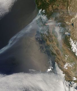
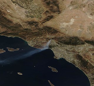
The 2007 California wildfire season saw at least 9,093 separate wildfires that charred 1,520,362 acres (6,152.69 km2) of land. Thirty of those wildfires were part of the Fall 2007 California firestorm, which burned approximately 972,147 acres of land from Santa Barbara County to the U.S.–Mexico border. At the peak of the wildfire activity in October 2007, the raging wildfires were visible from space.

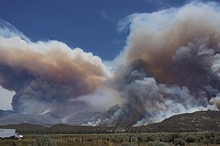
The Witch Creek Fire, also known as the Witch Fire and the Witch Creek-Guejito–Poomacha Complex Fire, was the second-largest wildfire of the 2007 California wildfire season, and the largest one of the October 2007 California wildfires. Although the Witch Creek Fire was individually smaller than the Zaca Fire of 2007, burning 197,990 acres (801 km2) acres alone, after merging with the Poomacha and McCoy Fires, the Witch–Guejito–Poomacha Complex Fire had a total burn area of 247,800 acres (1,003 km2), surpassing the Zaca Fire to become the largest complex fire of 2007. Initially igniting in Witch Creek Canyon, near Santa Ysabel, the Witch Creek Fire rapidly spread westward, fanned by powerful Santa Ana winds, and consumed large portions of San Diego County. On October 25, the Witch Fire merged with the Poomacha Fire to the north, near Palomar Mountain, before also merging with the smaller McCoy Fire on the next day. The Witch–Poomacha Complex Fire was the last fire of the 2007 October wildfires to be extinguished, with the Poomacha Fire being contained on November 13. During its duration, 80–100 feet-high flames were reported by fire officials in the Witch Fire, and the Witch Fire exhibited the characteristics of a firestorm at its height.
The 2008 California wildfire season was one of the most devastating since the turn of the 21st Century. While only 4,923 fires occurred, about half as many as in 2007, the total area burned far exceeded that of previous years. Throughout the year, 1,593,690 acres (6,449.4 km2) of land were burned.

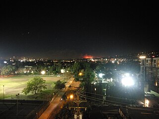
The Sayre Fire, also known as the Sylmar Fire, was a November 2008 wildfire that resulted in the loss of 489 residences in Los Angeles, California, United States, the "worst loss of homes due to fire" in the city's history. The fire was first reported at 10:29 p.m. PDT on November 14, 2008, in the Sylmar section of Los Angeles. As of November 20, 2008, the fire was 100% contained, had burned 11,262 acres (46 km2) and destroyed more than 600 structures. The number of homes lost in the Sayre fire exceeded the prior record set in 1961 by the Bel Air Fire which claimed 484 homes. There were no fatalities, just minor injuries to five firefighters and one civilian.
The Mountain Fire was a wildfire in July, 2013 in Mountain Center, Riverside County, California, about 100 miles east of Los Angeles. It burned primarily in the San Jacinto Mountains in the San Bernardino National Forest. It started on July 15, 2013 at 1:43 PM near the junction of Highway 243 and Highway 74. It burned for 16 days on steep slopes of timber and chaparral above Palm Springs. Heavy rainfall, up to 1.5 inches (3.8 cm), on July 21 helped bring the blaze under control. It was fully contained on July 30, 2013.
The Poinsettia Fire was the second most destructive of the May 2014 San Diego County wildfires. It caused property damage estimated at $22.5 million, as well as the only reported fatality in the San Diego County series of wildfires. As of July 10, 2014, the cause of the fire is listed as "undetermined", which allows for further investigation if more information comes to light.
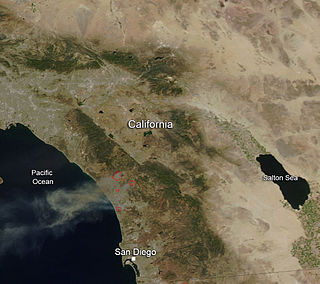
The May 2014 San Diego County wildfires were a swarm of 20 wildfires that erupted during May 2014, in San Diego County, California, during severe Santa Ana Wind conditions, historic drought conditions, and a heat wave. The main event during mid-May was preceded by a precursor fire that ignited on May 5. The Bernardo Fire has been declared accidental, and officials believe the Cocos Fire was intentionally set. The causes of the other fires are still under investigation by multiple agencies, and a joint task force was formed to coordinate the investigations and facilitate communications. Six injuries and one fire-related fatality were reported.
The Wragg Fire was a wildland fire that started just off California State Route 128 near Lake Berryessa in Napa County, California in the United States. The fire started on July 22, 2015. The cause was an idling vehicle's car exhaust. The vehicle came into contact with dry grass and sparked the fire. Mandatory evacuations for 136 homes and 200 residents took place. Six roads were closed temporarily as a result.

The October 2007 California wildfires, also known as the Fall 2007 California firestorm, were a series of about thirty wildfires that began igniting across Southern California on October 20. At least 1,500 homes were destroyed and approximately 972,147 acres of land was burned from Santa Barbara County to the U.S.–Mexico border, surpassing the October 2003 California wildfires in scope, which were estimated to have burned 800,000 acres (3,200 km2). The wildfires killed a total of 14 people, with nine of them dying directly from the fires; 160 others were injured, including at least 124 firefighters. At their height, the raging fires were visible from space. These fires included the vast majority of the largest and deadliest wildfires of the 2007 California wildfire season. The only wildfire in 2007 that surpassed any of the individual October 2007 fires in size was the Zaca Fire.

The Blue Cut Fire was a wildfire in the Cajon Pass, northeastern San Gabriel Mountains, and Mojave Desert in San Bernardino County, California. The fire, which began on the Blue Cut hiking trail in the San Bernardino National Forest, was first reported on August 16, 2016 at 10:36 a.m., just west of Interstate 15. A red flag warning was in effect in the area of the fire, with temperatures near 100 °F (38 °C) and winds gusting up to 30 miles per hour (48 km/h).

In terms of property damage, 2017 was the most destructive wildfire season on record in California at the time, with a total of 9,133 fires burning 1,381,405 acres (5,590.35 km2) of land, according to the California Department of Forestry and Fire Protection, including five of the 20 most destructive wildland-urban interface fires in the state's history. Throughout 2017, the fires destroyed or damaged more than 10,000 structures in the state, a higher tally than the previous nine years combined. State data showed that the large wildfires killed 47 people – 45 civilians and 2 firefighters – almost higher than the previous 10 years combined. The total property damage was surpassed by the 2018 California wildfires.

The Holcomb Fire was a wildfire that burned due north of Big Bear Lake near Highway 18 in the San Bernardino National Forest in San Bernardino County, California. Within several days, the fire would consume some 1,500 plus acres as it threatened the areas of Baldwin Lake and Highway 18. However, while the fire rapidly grew in size, the head of the fire was seen to be moving away from structures, thus leaving evacuated areas under voluntary evacuation.
The Skirball Fire was a wildfire that burned in the Bel Air neighborhood of Los Angeles, California, United States, and one of multiple wildfires that broke out across Southern California in December 2017. The fire burned 422 acres of land on the slopes of the Sepulveda Pass on its east or Bel Air side, causing the closure of Interstate 405, a major traffic artery in the city. The Skirball Cultural Center, Bel-Air Country Club, Getty Center, Santa Monica-Malibu Unified School District, and various private schools were closed as a result of the fire. Classes were cancelled at the University of California, Los Angeles (UCLA) and Santa Monica College, while Mount Saint Mary's University evacuated from its Brentwood campus to its downtown Los Angeles location. The fire destroyed six structures and damaged 12. On December 10, at about 1 p.m. PST, all evacuation orders and road closures for the Skirball Fire were lifted, as containment of the wildfire increased to 85%. Late on December 15, it was reported that the Skirball Fire had been 100% contained, at 422 acres (171 ha).

The Creek Fire was a large wildfire that burned in Kagel Canyon and the Angeles National Forest north of Sylmar, a neighborhood in Los Angeles, California, United States, and one of multiple wildfires that broke out across Southern California in December 2017. The Creek Fire has burned 15,619 acres (63 km2) and destroyed 123 structures, including 60 homes, before being contained on January 9, 2018, following heavy rainfall from a winter storm. The fire threatened the communities of Santa Clarita, Glendale, Olive View, Lake View Terrace, Sunland-Tujunga, Shadow Hills, Sylmar, Pacoima, Lopez Canyon, and Kagel Canyon, as well as the Olive View–UCLA Medical Center. During the wildfire, 115,000 residents were forced to evacuate their homes.

A series of 29 wildfires ignited across Southern California in December 2017. Six of the fires became significant wildfires, and led to widespread evacuations and property losses. The wildfires burned over 307,900 acres (1,246 km2), and caused traffic disruptions, school closures, hazardous air conditions, and power outages; over 230,000 people were forced to evacuate. The largest of the wildfires was the Thomas Fire, which grew to 281,893 acres (1,140.78 km2), and became the largest wildfire in modern California history, until it was surpassed by the Ranch Fire in the Mendocino Complex, in the following year.

The Lilac Fire was a fire that burned in northern San Diego County, California, United States, and the second-costliest one of multiple wildfires that erupted in Southern California in December 2017. The fire was first reported on December 7, 2017, burned 4,100 acres (1,659 ha), and destroyed 157 structures, before it was fully contained on December 16. The fire cost at least $8.9 million, including $5 million in firefighting expenses and property damage, and an additional $3.9 million in cleanup and erosion control costs. The fire threatened the communities of Bonsall, Oceanside, Vista, Fallbrook, and Camp Pendleton. During the fire, an estimated 10,000 residents were forced to evacuate, while a total of over 100,000 residents were forced to or advised to evacuate. On December 7, the Lilac Fire also cut the power to 20,000 people.
The Saddleridge Fire was a wildfire burning near the San Fernando Valley of Los Angeles County, California. It broke out roughly around 9:02pm on Thursday October 10, 2019. It is still undetermined as to how it had started, but believed that the blaze had started beneath a high voltage transmission tower. Reporters and first responders began to assess the fire, the main location at the time of ignition was at the entrance of Interstate 210 and Yarnell Street. Residents were being evacuated, shop owners standing by in hopes their shops were still up, and many of the community helping with evacuating all animals from surrounding farms and ranches. The fire was fully extinguished on Thursday October 31, 2019, 20 days after first igniting. The fire burned 8,799 acres and resulted in 8 injuries and 1 fatality.

