Baxter County is a county in the Ozark Mountains of Arkansas. Created as Arkansas's 66th county on March 24, 1873, the county has eight incorporated municipalities, including Mountain Home, its largest city and county seat. The county is named for Elisha Baxter, the tenth governor of Arkansas. It is coterminal with the Mountain Home Micropolitan Statistical Area.

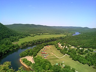
Norfork Dam impounds the North Fork River in the U.S. state of Arkansas, creating Norfork Lake. The large reservoir is maintained by the United States Army Corps of Engineers and spans Baxter County, Arkansas, Fulton County, Arkansas and Ozark County, Missouri. The dam is located in the city of Salesville in Baxter County, within the Ozark Mountains.

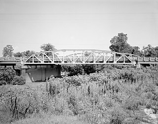
The Cotter Bridge, also known as the R. M. Ruthven Bridge and the White River Concrete Arch Bridge, carries U.S. Route 62 Business across the White River west of the city of Cotter in Baxter County, Arkansas. Upon completion, the bridge opened a part of the Ozarks previously inaccessible to motorists. Constructed in 1930, it is the only bridge built by the Marsh Engineering Company of Des Moines, Iowa, in the state of Arkansas.

The St. Louis-San Francisco Overpass is a pony and deck truss bridge built in 1937 located in Imboden, Lawrence County, Arkansas. It carries U.S. Route 62 and Arkansas Highway 115 over the Spring River and the former St. Louis-San Francisco Railroad for 1,049.9 feet (320.0 m). The bridge has three Pratt deck trusses, each 112 feet (34 m) in length, and three Parker pony trusses, also 112 feet (34 m) long, with the balance of the bridge length in steel girder truss spans. The bridge is 24 feet (7.3 m) wide.
The Vincennes Bridge Company, based in Vincennes, Indiana, was a designer and builder of bridges that was "one of Indiana's 'most successful bridge-building firms'".

The AJX Bridge is a historic Pratt truss bridge in southwestern Johnson County, Wyoming. The bridge was built in 1931 across the South Fork of the Powder River near Kaycee, Wyoming. AJX Bridge was built to provide a river crossing for U.S. Route 87. It was placed on the National Register of Historic Places in 1985 as part of a Multiple Property Submission devoted to historic bridges in Wyoming.

The Beaver Bridge in Beaver, Arkansas, is a historic one-lane suspension bridge carrying Arkansas Highway 187 over the White River at Table Rock Lake. Built in 1949 by the Pioneer Construction Company, the structure is the only suspension bridge open to traffic in Arkansas. The Beaver Bridge was added to the National Register of Historic Places in 1990.

The Black River Bridge carries U.S. Route 67 (US 67) across the Black River in Pocahontas, Arkansas. The bridge is a twin span, each carrying two lanes of traffic. The northern bridge was a historic structure, built in 1934 by the Pittsburgh-Des Moines Steel Co., and was listed on the National Register of Historic Places. In 2016 demolition began on the northern bridge, and it was delisted in 2018. This bridge consisted of two Parker trusses, one on either side of a Warren swing span, and trestled approaches, giving it a total length of 1,255 feet (383 m). It was one of three surviving swing bridges in the state. The southern bridge is a modern steel girder structure, built in 1986, whose construction rendered the swing section inoperative.

The Haggard Ford Swinging Bridge is a historic suspension bridge in Boone County, Arkansas. It is located adjacent to Cottonwood Road, about 8 miles (13 km) north of Harrison, and spans Bear Creek. It has cast-in-place concrete abutments, towers, and anchorages, and is supported by steel cables. A wooden deck, one travel lane in width, is suspended from steel hangers. The bridge is about 160 feet (49 m) long. The bridge was built 1938–41 with funding from the Works Progress Administration. Fill surrounding the abutments was washed away in 1945 and subsequently replaced. The bridge deck was replaced in 1977.

The Frog Bayou Bridge is a historic bridge in Crawford County, Arkansas, just south of Mountainburg. It is a single-span steel Parker through truss, which formerly carried Arkansas Highway 282 across Frog Bayou, a tributary of the Arkansas River. The bridge is now closed to traffic, and is located at the southern end of Silver Bridge Road. The bridge has a span of 150 feet (46 m) and a total structure length of 209 feet (64 m), and rests on abutments of stone and concrete. The northern approach to the bridge also includes a stone and concrete pier. The bridge was built in 1942.

The Mountain Fork Bridge is a historic bridge in rural Polk County, Arkansas. It carries County Road 38 across Mountain Fork Creek north of Hatfield and southwest of Mena. The bridge consists of two spans of steel Pratt pony trusses, with a total length of 406 feet (124 m), including approach spans. The trusses are set on piers consisting of steel rings filled with concrete; each of these spans is 80 feet (24 m) long. The bridge's construction date and builder are unknown; it predates the standardization of bridge designs in the state in 1923. It is estimated to date to the early 1900s.

The Highway 79 Bridge was a historic bridge in Clarendon, Arkansas. It was a tall two-span Warren truss bridge, formerly carrying two-lane U.S. Route 79 (US 79), a major arterial highway in the region, across the White River just west of the city's downtown. The steel truss had a total length of 720 feet (220 m), set on four concrete piers. The outer pairs of piers were 160 feet (49 m) apart, and the middle pair were 400 feet (120 m) apart. The approaches were concrete, set on concrete pilings, with the western approach continuing for some 3 miles (4.8 km) across secondary water bodies. The bridge was built in 1930-31 by the Austin Bridge Company.

The Newport Bridge is a historic cantilevered Warren truss bridge over the White River in Newport, Arkansas. Built in 1930 to carry U.S. Route 67 (US 67), the road it carries is now designated Arkansas Highway 367 (AR 367) after the former highway was relocated. The main bridge is 400 feet (120 m) long, with approaches from the west of 1,278 feet (390 m) and the south of 911 feet (278 m). It has cantilevered arms 138 feet (42 m) long supported by concrete piers, with a suspended Warren truss span of 125 feet (38 m). Designed by Ira G. Hedrick, it is one of three such bridges in the state.
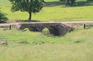
The Cedar Creek Bridge is a historic bridge in rural southern Independence County, Arkansas. It is located on Goodie Creek Road, about 1.5 miles (2.4 km) south of its junction with Arkansas Highway 14. It is a two-span stone masonry structure, spanning Cedar Creek, a tributary to the White River, with two closed-spandrel arches having a total length of 30 feet (9.1 m). Its deck is 24.1 feet (7.3 m) wide, with a total structure width of 26.1 feet (8.0 m), including the parapets at the sides. The bridge was built 1941, and was probably designed by an engineer of the state's highway department.

The Harp Creek Bridge is a historic bridge in rural northern Newton County, Arkansas, carrying Arkansas Highway 7 across Harp Creek in the hamlet of Harrison. It is an open-spandrel arch bridge, built out of reinforced concrete in 1928 by the Luten Bridge Company. The arches span 69 feet (21 m), and are mounted on piers set 24 feet (7.3 m) from the abutments. The total structure length is 117 feet (36 m), and the deck is 23 feet (7.0 m) wide. Concrete balustrades line the sides of the bridge.

The South Fork Bridge is a historic bridge spanning the South Fork Saline River in Fountain Lake, Arkansas. It formerly carried Arkansas Highway 128, whose modern bridge now stands just to the south, a short way east of its junction with Arkansas Highway 5. It is a two-span concrete closed-spandrel arch structure, with spans of 57 feet (17 m) and a roadway width of 16 feet (4.9 m). It was built in 1928 by a county crew, after major flooding in 1927 damaged road infrastructure in the area.

The Middle Fork of the Little Red River Bridge, also known as the Shirley Railroad Bridge, is a historic bridge in Shirley, Arkansas. It is a single-span iron Baltimore through truss, with a main span 153 feet (47 m) long, and steel beam approach spans giving it a total length of 339 feet (103 m). The main span rests on large concrete piers set in the river. The bridge was built in 1908 for the Missouri and North Arkansas Railroad, and carried the railroad until 1949. In 1978 the tracks were covered by a concrete deck, and the bridge was converted to single-lane vehicular road use, carrying County Road 125.

The Fourche LaFave River Bridge carries Arkansas Highway 7 across the Fourche LaFave River in western Perry County, Arkansas, downstream of the Nimrod Dam. It is a three-span open spandrel concrete arch bridge, with its longest span measuring 184 feet (56 m), and its total length 518 feet (158 m). The arches are mounted on concrete abutments and piers. The bridge deck is asphalt, and is lined by ornate concrete balustrades. It was built in 1941 by the Luten Bridge Company, and is a well-preserved example of style from that period.

The Big Piney Creek Bridge is a historic bridge, carrying Arkansas Highway 123 across Big Piney Creek in Ozark-St. Francis National Forest, northeast of Hagarville, Arkansas. Its main span is a Warren through truss structure, 141 feet (43 m) in length, with steel deck girder approach spans giving the bridge a total length of 461 feet (141 m). The trusses are mounted on concrete piers. The bridge was built in 1931, during a period of financial hardship, and was for economic reasons built with a single-lane 12-foot (3.7 m) roadway.
The Petit Jean River Bridge is a historic bridge in rural southern Logan County, Arkansas. The bridge carries Old Highway 109 across the Petit Jean River between Sugar Grove and Magazine. It consists of a single-span steel Pratt through truss and two masonry approach spans, set on concrete piers in the river. The total structure length is 273 feet (83 m), with a roadway width of 19 feet (5.8 m) and a total width of 24 feet (7.3 m). The bridge was built in 1938.


