North Carolina is a state in the Southeastern region of the United States. The state is the 28th largest and 9th-most populous of the United States. It is bordered by Virginia to the north, the Atlantic Ocean to the east, Georgia and South Carolina to the south, and Tennessee to the west. In the 2020 census, the state had a population of 10,439,388. Raleigh is the state's capital and Charlotte is its largest city. The Charlotte metropolitan area, with a population of 2,595,027 in 2020, is the most-populous metropolitan area in North Carolina, the 21st-most populous in the United States, and the largest banking center in the nation after New York City. The Raleigh-Durham-Cary combined statistical area is the second-largest metropolitan area in the state and 32nd-most populous in the United States, with a population of 2,043,867 in 2020, and is home to the largest research park in the United States, Research Triangle Park.

The Western Hemisphere is the half of the planet Earth that lies west of the Prime Meridian and east of the 180th meridian. The other half is called the Eastern Hemisphere. Politically, the term Western Hemisphere is often used as a metonym for the Americas, even though geographically the hemisphere also includes parts of other continents.

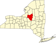
Verona is a town in southwestern Oneida County, New York, United States. The population was 6,293 at the 2010 census. The town was named after Verona, Italy.

Western is a town in Oneida County, New York, United States. The population was 1,951 at the 2010 census.

The West Coast of the United States – also known as the Pacific Coast, the Pacific Seaboard, and the Western Seaboard – is the coastline along which the Western United States meets the North Pacific Ocean. The term typically refers to the contiguous U.S. states of California, Oregon, and Washington, but sometimes includes Alaska and Hawaii, especially by the United States Census Bureau as a U.S. geographic division.

The Western United States is the region comprising the westernmost U.S. states. As American settlement in the U.S. expanded westward, the meaning of the term the West changed. Before around 1800, the crest of the Appalachian Mountains was seen as the western frontier. The frontier moved westward and eventually the lands west of the Mississippi River were considered the West.

United States attorneys are officials of the U.S. Department of Justice who serve as the chief federal law enforcement officers in each of the 94 U.S. federal judicial districts. Each U.S. attorney serves as the United States' chief federal criminal prosecutor in their judicial district and represents the U.S. federal government in civil litigation in federal and state court within their geographic jurisdiction. U.S. attorneys must be nominated by the President and confirmed by the Senate, after which they serve four-year terms.

A coastal plain is flat, low-lying land adjacent to a sea coast. A fall line commonly marks the border between a coastal plain and a piedmont area. Some of the largest coastal plains are in Alaska and the southeastern United States. The Gulf Coastal Plain of North America extends northwards from the Gulf of Mexico along the Lower Mississippi River to the Ohio River, which is a distance of about 981 miles (1,579 km). The Atlantic Coastal Plain runs from the New York Bight to Florida.

An oceanic climate, also known as a marine climate, is the temperate climate sub-type in Köppen classification represented as Cfb, typical of west coasts in higher middle latitudes of continents, generally featuring cool summers and mild winters, with a relatively narrow annual temperature range and few extremes of temperature. Oceanic climates can be found in both hemispheres generally between 45 and 63 latitude, most notably in northwestern Europe, northwestern America, as well as New Zealand. Other varieties of climates usually classified together with these include subtropical highland climates, represented as Cwb or Cfb, and subpolar oceanic climates, represented as Cfc or Cwc. Subtropical highland climates occur in some mountainous parts of the subtropics or tropics, some of which have monsoon influence, while subpolar oceanic climates occur near polar regions.

Ascutney is an unincorporated village and census-designated place (CDP) in the town of Weathersfield, Windsor County, Vermont, United States. It is located in the northeastern section of Weathersfield, in the portion of that town adjacent to Mount Ascutney, after which the village is named. As of the 2010 census, the population of the CDP was 540.

Indiana's 4th congressional district is a congressional district in the U.S. state of Indiana. From 2003 to 2013 the district was based primarily in the central part of the state, and consisted of all of Boone, Clinton, Hendricks, Morgan, Lawrence, Montgomery, and Tippecanoe counties and parts of Fountain, Johnson, Marion, Monroe, and White counties. The district surrounded Indianapolis including the suburban area of Greenwood and encompassed the more exurban areas of Crawfordsville and Bedford, as well as the college town of Lafayette-West Lafayette, containing Purdue University.

Western North Carolina is the region of North Carolina which includes the Appalachian Mountains; it is often known geographically as the state's Mountain Region. It contains the highest mountains in the Eastern United States, with 125 peaks rising to over 5,000 feet in elevation. Mount Mitchell at 6,684 feet, is the highest peak of the Appalachian Mountains and mainland eastern North America. The population of the region, as measured by the 2010 U.S. Census, is 1,473,241, which is approximately 15% of North Carolina's total population.
The Fortune Global 500, also known as Global 500, is an annual ranking of the top 500 corporations worldwide as measured by revenue. The list is compiled and published annually by Fortune magazine.
The meridian 90° west of Greenwich is a line of longitude that extends from the North Pole across the Arctic Ocean, North America, the Gulf of Mexico, Central America, the Pacific Ocean, the Southern Ocean, and Antarctica to the South Pole.

The Mountain states form one of the nine geographic divisions of the United States that are officially recognized by the United States Census Bureau. It is a subregion of the Western United States.
Monte Nido is an unincorporated community in western Los Angeles County, California, United States. Monte Nido is located in the Santa Monica Mountains 3 miles (4.8 km) north of Malibu.
The Pennsylvania State Game Lands Number 166 are Pennsylvania State Game Lands in Blair and Huntingdon Counties in Pennsylvania in the United States providing hunting, trapping, bird watching, and other activities.


