
Cross County is a rural Northeast Arkansas county in the Arkansas Delta. Created as Arkansas's 53rd county on November 15, 1862, Cross County contains four incorporated municipalities, including Wynne, the county seat and most populous city. It is named for Confederate Colonel David C. Cross, a political leader in the area.

The National Register of Historic Places in the United States is a register including buildings, sites, structures, districts, and objects. The Register automatically includes all National Historic Landmarks as well as all historic areas administered by the U.S. National Park Service. Since its introduction in 1966, more than 90,000 separate listings have been added to the register.

Highway 22 is an east–west state highway in the Arkansas River Valley. It is maintained by the Arkansas State Highway and Transportation Department (AHTD). The highway runs 75.60 miles (121.67 km) from US 64/US 71B east to Highway 7 in Dardanelle. Following the historic stagecoach line of the cross-country Butterfield Trail, the highway is one of the original 1926 state highways. It is designated by the AHTD as the True Grit Trail.
Arkansas Highway 10 is an east–west state highway in West Arkansas. The route runs 135.41 miles (217.92 km) from Oklahoma State Highway 120 near Hackett east to Interstate 30 in Little Rock, the state's capitol. The highway serves both the Fort Smith metropolitan area and the Little Rock – North Little Rock – Conway metropolitan area.
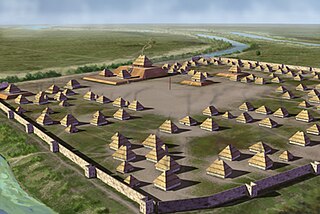
Parkin Archeological State Park, also known as Parkin Indian Mound, is an archeological site and state park in Parkin, Cross County, Arkansas. Around 1350–1650 CE an aboriginal palisaded village existed at the site, at the confluence of the St. Francis and Tyronza rivers. Artifacts from this site are on display at the site museum. The Parkin Site is the type site for the Parkin phase, an expression of the Mississippian culture from the Late Mississippian period. Many archeologists believe it to be part of the province of Casqui, documented as visited by Spanish explorer Hernando de Soto in 1542. Archeological artifacts from the village of the Parkin people are dated to 1400–1650 CE.

Hampson Archeological Museum State Park is a 5-acre (2.0 ha) Arkansas state park in Mississippi County, Arkansas in the United States. The museum contains a collection of archeological artifacts from the Nodena Site, which is a former Native American village on the Mississippi River between 1400 and 1650. James K. Hampson began excavating the site in the 1920s, a museum was built in 1946 and the Arkansas General Assembly officially accepted the collection of artifacts from the Hampson family on March 30, 1957. The park first opened in 1961 as Hampson Museum State Park and has since been renamed.

U.S. Route 64 is a U.S. highway running from Teec Nos Pos, Arizona east to Nags Head, North Carolina. In the U.S. state of Arkansas, the route runs 246.35 miles (396.46 km) from the Oklahoma border in Fort Smith east to the Tennessee border in Memphis. The route passes through several cities and towns, including Fort Smith, Clarksville, Russellville, Conway, Searcy, and West Memphis. US 64 runs parallel to Interstate 40 until Conway, when I-40 takes a more southerly route.
Highway 126 is a designation for two north–south state highways in Baxter County, Arkansas. A southern route of 11.66 miles (18.76 km) runs from Buffalo City north to US Route 62/US Route 412 (US 62/US 412) near Mountain Home. A second route of 7.03 miles (11.31 km) begins at US 62/US 412 in Gassville and runs north to Highway 5/Highway 178 at Midway.

This is a list of the National Register of Historic Places listings in Cross County, Arkansas.

Highway 190 is a designation for four state highways in Arkansas. Three are low-traffic rural highways in Grant County, with one designation along city streets in Pine Bluff. The rural segments were created in 1965 and 1966, with the Pine Bluff section created in 2000 as a renumbering of Highway 104. All segments are maintained by the Arkansas Department of Transportation (ARDOT).

The Immaculate Heart of Mary Church is a historic Roman Catholic church in northern Pulaski County, Arkansas. It is located off Arkansas Highway 365 on Blue Hill in Marche, north of North Little Rock.

The Beaver Bridge in Beaver, Arkansas is a historic one-lane suspension bridge carrying Arkansas Highway 187 over the White River at Table Rock Lake. Built in 1949 by the Pioneer Construction Company, the structure is the only suspension bridge open to traffic in Arkansas. The Beaver Bridge was added to the National Register of Historic Places in 1990.

U.S. Highway 71 is a U.S. highway that runs from Krotz Springs, LA to the Fort Frances–International Falls International Bridge at the Canadian border. In Arkansas, the highway runs from the Louisiana state line near Doddridge to the Missouri state line near Bella Vista. In Texarkana, the highway runs along State Line Avenue with US 59 and partially runs in Texas. Other areas served by the highway include Fort Smith and Northwest Arkansas.

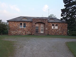
The Smithville Public School Building is a historic school building on Arkansas Highway 117 in the small community of Smithville, Arkansas. It is a single-story T-shaped fieldstone structure with a cross-gable roof.

The Immaculate Heart of Mary School is a historic school building on the campus of the Immaculate Heart of Mary Church in northern Pulaski County, Arkansas. It is located off Arkansas Highway 365, north of North Little Rock and east of Marche. The building is a single-story wood-frame building with Craftsman styling. It has a gable-on-hip roof with a front porch supported by square brick columns, with false timbering applied over vertical boards in the gable end. The building was built in 1925 by the church's head carpenter, George Makowski.
The Dill School is a historic school building in rural Cleburne County, Arkansas. It is located a short way north of the village of Ida, on the west side of Arkansas Highway 5/25. It is a single story stone structure, with a broad hipped roof and four "eyebrow dormers". It has a pair of entrances sheltered by an arched projection that extends above the roof line. The northern support column of the portico is marked by a stone indicating the year of construction (1938), and that it was built with funding from the National Youth Administration. The building was used as a school until 1948, when its student population was consolidated into adjacent school districts. It has since seen a variety of other uses.
Highway 51 is a designation for two north–south state highways in Southwest Arkansas. One route of 53.37 miles (85.89 km) begins Highway 53 near Whelen Springs and runs north to US Highway 67 in Donaldson. A second route of 7.92 miles (12.75 km) runs parallel to US 270 northwest of Malvern. Both routes are maintained by the Arkansas Department of Transportation (ArDOT).
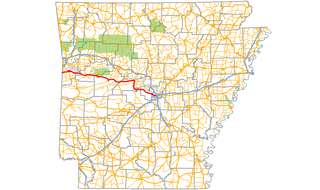
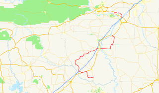
Highway 184 is an east–west state highway in the Arkansas Delta. The route begins at US Highway 64 (US 64) in Parkin and runs east 7.30 miles (11.75 km) to US 64 in Earle. The route is maintained by the Arkansas Department of Transportation (ArDOT).


