Northern Region, Nigeria

Last updated
Northern Nigeria
Arewacin Najeriya (Hausa)
Flag of the Northern Nigeria Protectorate (1900-1914).svg
Flag
Defunct Arewa Coat of Arm.png
Coat of arms
Motto: Aiki da Ibada
"Work and Worship"
Anthem:  National Anthem of Northern Nigeria
Northernnigeria.png
Capital Lokoja
(1897–1903)
Zungeru
(1903–1923)
Kaduna
(1923–1966)
Largest city Kano
Official languages Hausa language
Major languages
Government Constitutional Monarchy
(1897–1963)
Federation
(1963–1966)
  Governors
Sir Ahmadu Bello
Legislature Northern Regional Legislature
House of Chiefs [1]
House of Assembly [2]
Establishment
 Proclamation of Protectorate
1897
 Independence
15 March 1953
 Republic declared
1 October 1963
Area
 Total
660,000 km2 (250,000 sq mi)
Population
 Estimate
9,000,000 [ citation needed ]
 1950 census census
6,383,682 [ citation needed ]
Preceded by
Succeeded by
Blank.png Northern Nigeria Protectorate
Federation of Nigeria Blank.png
Today part of Nigeria

Northern Nigeria (or Arewancin Nijeriya ) was an autonomous division within Nigeria, distinctly different from the southern part of the country, with independent customs, foreign relations and security structures. In 1962, it acquired the territory of the British Northern Cameroons, which voted to become a province within Northern Nigeria. [3]

Contents

In 1967, Northern Nigeria was divided into the North-Eastern State, North-Western State, Kano State, Kaduna State, Kwara State, and the Benue-Plateau State, each with its own Governor. [4]

History

Prehistory

Area of the Nok culture Nok-map.png
Area of the Nok culture

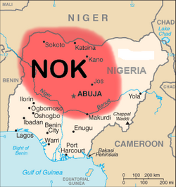
The Nok culture, an ancient culture dominated most of what is now Northern Nigeria in prehistoric times, its legacy in the form of terracotta statues and megaliths have been discovered in Sokoto, Kano, Birinin Kudu, Nok and Zaria. The Kwatarkwashi culture, a variant of the Nok culture centred mostly around Zamfara in Sokoto Province is thought by some to be the same or an offshoot of the Nok. [5]

The Fourteen Kingdoms

The Fourteen Kingdoms unified the diverse lore and heritage of Northern Nigeria into a cohesive ethno-historical system. Seven of these kingdoms developed from the Kabara legacy of the Hausa people. In the 9th century as vibrant trading centers competing with Kanem-Bornu and Mali slowly developed in the Central Sudan, a collection of kingdoms merged – the Hausa Kingdoms or Hausa Bakwai – dominating the great savannah plains of Hausaland. Their primary exports were leather, gold, cloth, salt, kola nuts, animal hides, and henna. [6]

The seven Hausa states included:

The growth and conquest of the Hausa Bakwai resulted in the founding of additional states with rulers tracing their lineage to a concubine of the Hausa founding father, Bayajidda. Thus, they are called the Banza Bakwai, meaning Bastard Seven. [7] The Banza Bakwai adopted many of the customs and institutions of the Hausa Bakwai but were considered unsanctioned or copy-cat kingdoms by non-Hausa people. These states include:

Hausa States

Between 500 and 700, Hausa people, who are thought to have slowly moved from Nubia and mixing in with the local Northern population, established a number of strong states in what is now Northern Nigeria and Eastern Niger. With the decline of the Nok and Sokoto, who had previously controlled Central and Northern Nigeria between 800 BCE and 200, the Hausa were able to emerge as the new power in the region. They are closely linked with the Kanuri people of Kanem-Bornu (Lake Chad), the Birom, Gwari, Nupe and Jukun.

The Hausa aristocracy, under influence from the Mali Empire adopted Islam in the 11th century. By the 12th century, the Hausa were becoming one of Africa's major powers. The architecture of the Hausa is perhaps one of the least known but most beautiful of the medieval age. Many of their early mosques and palaces are bright and colourful and often include intricate engraving or elaborate symbols designed into the facade. By 1500, the Hausa utilized a modified Arabic script known as Ajami to record their own language; the Hausa compiled several written histories, the most popular being the Kano Chronicle. [8]

Fulani Empire and Bornu Empire

Usman Dan Fodio, the 18th century revolutionary and a social, religious and political reformer finally united the seven Hausa States with newly created provinces into the Sokoto Caliphate. The Sokoto Caliphate was under the overall authority of the Commander of the Faithful. Under Dan Fodio, the Empire was bicephalous and divided into two territories each controlled by an appointed vizier. Each of the territories was further divided into autonomous Emirates under mainly hereditary local Emirs. The Bornu Empire was initially absorbed into the Sokoto Caliphate of Usman dan Fodio but broke away a few years later. [8]

Colonisation

Initially, the British involvement in Northern Nigeria was predominantly trade-related and revolved around the expansion of the Royal Niger Company, whose interior territories spread north from about where the Niger River and Benue River joined at Lokoja the Mount Patti hill. The Royal Niger Company's territory did not represent a direct threat to much the Sokoto Caliphate or the numerous states of Northern Nigeria. This changed, when Frederick Lugard and Taubman Goldie laid down an ambitious plan to pacify the Niger interior and unite it with the rest of the British Empire. [9]

History of the Protectorate of Northern Nigeria

Map of Nigeria, 1909 Nigeria 1909.jpg
Map of Nigeria, 1909

The protectorate of Northern Nigeria was proclaimed at Ida by Frederick Lugard on January 1, 1897. The basis of the protectorate was the 1885 Treaty of Berlin which broadly granted Northern Nigeria to the British sphere of influence, on the basis of their existing protectorates in Southern Nigeria. Hostilities with the powerful Sokoto Caliphate soon followed. the Emirates of Kontagora and Ilorin were the first to be conquered by the British. In February 1903, the great fort of Kano, seat of the Kano Emirate was captured, Sokoto and much of the rest of its Caliphate soon capitulated. [10]

On 13 March 1903, the Grand Shura of Caliphate finally conceded to Lugard's demands and proclaimed Queen Victoria as suzerain of the Caliphate and all its lands. [9]

Governor Lugard, with limited resources, controlled the region with the consent of local rulers through a policy of indirect rule, which he developed into a sophisticated political theory. The geographical area included in the Northern Nigeria Protectorate included the Okun-Yoruba land of Kabba, Ogidi, Ijumu, Gbede, Yagba, as well as Ebira land, Igala land fashioned collectively under Kabba Province. The Ifelodun, Offa, Omuaran, Ifelodun and Irepodun areas, also Yorubas, were fashioned into Ilorin province. Lugard left the protectorate after some years, serving in Hong Kong, but was eventually returned to work in Nigeria, where in 1914 he sought the merger of the Northern Nigeria Protectorate with Southern Nigeria, creating the Colony and Protectorate of Nigeria. [11]

Agitation for independence from the radically different Southern Protectorate, however, led to a formidable split in the 1940s. The Richards constitution proclaimed in 1945, gave overwhelming autonomy to the North, including eventually in the areas of foreign relations and customs policy. [12]

Independence

Northern Nigeria gained self-government on 15 March 1957 with Sir Ahmadu Bello as its first premier. the Northern Peoples Congress under Bello dominated parliament while the Northern Elements Progressive Union became the main opposition party. [13]

In 1967, Northern Nigeria was disestablished by subdivision.

Government and politics

The government of Northern Nigeria was modelled after the Westminster system. A premier acted as head of government and presided over the day-to-day affairs of government, while a Governor of Northern Nigeria acted as viceroy and as commander-in-chief of the constabulary.[ citation needed ]

The lower house of parliament, called the House of Assembly was composed of elected representatives from the various provinces of the country. The Upper House of parliament, called the House of Chefs, was similar to the British House of Lords, composed of unelected emirs of the various Native Authority Councils of the nation's provinces. [14]

In 1967, the Federal Military Government of General Yakubu Gowon broke up the four regions that until then had constituted the Federation of Nigeria, creating twelve new states. Northern Nigeria was divided into the North-Eastern State, North-Western State, Kano State, Kaduna State, Kwara State, and the Benue-Plateau State, each with its own Governor and government. [15]

Governor

The High Commissioner or Governor of Northern Nigeria, originally the High Commissioner of the Northern Nigeria Protectorate, after 1914 the Lieutenant Governor, Chief Commissioner, or Governor-General of the Northern Provinces of Nigeria, was effectively the viceroy of Northern Nigeria, exercising British suzerainty as representative of the Crown.[ citation needed ]

The office of High Commissioner was first established on 1 January 1897, by letters patent from Queen Victoria. After the departure of the British in 1960, a Governor continued to be appointed until 1967 as representative of the new administration in Lagos.[ citation needed ]

The governor presided over all ceremonial functions and appointed the members of the nation's upper legislative house, the Northern Nigerian House of Chiefs.

President of the House of Chiefs

Speakers of the House of Assembly

Geography

The highest point in Northern Nigeria is Chappal Waddi at 2,419 m (7,936 ft), which is located at gasha gumti Taraba state. The main rivers are the Niger and the Benue River which converge at Kabba province from where it travels southwards ultimately emptying into the Atlantic Ocean.[ citation needed ]

The expansive valleys of the Niger and Benue River valleys dominate the southern areas of the region. To the southeast of the Benue river, hills and mountains which forms the Mambilla Plateau create the highest plateau in Northern Nigeria with 1350 above sea level. This plateau extends to the border with Cameroon, this montane land forms part of the Bamenda Highlands in Cameroon. [14]

The great savanna belt of the Great Plains of Hausaland dominates much of the rest of the province. this region experiences rainfall between 20 and 60 inches (508 and 1,524 mm) per year. The savanna zone's three categories are Guinean forest-savanna mosaic, Sudan savanna, and Sahel savanna. [16] Guinean forest-savanna mosaic is plains of tall grass which are interrupted by trees. Sudan savanna is similar but with shorter grasses and shorter trees. Sahel savanna consists of patches of grass and sand, found in the northeast. In the Sahel region, rain is less than 20 inches (508 mm) per year and the Sahara Desert is encroaching. In the dry north-east corner of the country lies Lake Chad, which Northern Nigeria shares with Niger, Chad and Cameroon. [17]

The South Western part of the region included Ogidi, Iyamoye, Iyara that have deep forests inter spacing the guinea savannah areas (and borders the forested areas of southern protectorate and as such shared similar rain patterns and given to the cultivation of cash crops such as coffee and cocoa). [18]

Subdivisions

Northern Nigeria was divided into thirteen provinces:

  1. Bauchi
  2. Benue
  3. Borno
  4. Kano
  5. Katsina
  6. Plateau
  7. Kaduna
  8. Niger
  9. Adamawa
  10. Zaria
  11. Sokoto
  12. Kabba
  13. Ilorin

Kano, the largest of the provinces in terms of population and economy, is in the North-Central part of the country. The Kano Native Authority, an offshoot of the fula Kano Emirate, inherited the ancient trade industries that fuelled the trans-Saharan trade with North Africa.

The Province of Zaria is home to the City of Kaduna, an autonomous capital city that serves as the nation's capital and home to its national institutions. [19]

Economy

Groundnut and cotton industries in the province of Kano provided the main source of revenue for Northern Nigeria. Tin mining in the Province of Plateau, Steel mining in the Province of Benue, and other metal industries in the Province of Sokoto, built up the diverse mining industry of the region. [20]

Cement industries in Sokoto and Bauchi and Ashaka cement at Gombe leather processing industries in Kano constituted the main manufacturing sector. And also, irrigation plant at dadin kowa Dam Gombe State

Demographics

Northern Nigeria though an ethnically and religiously diverse region, is an overwhelmingly majority Muslim region. The Hausa, Fulani and Kanuri dominate much of the North Western and Eastern part of the country while the Yoruba, Nupe, Tiv, Igala and Idoma are dominant in the North Central. Hausa, Fulani, Nupe and the Kanuri people are chiefly Muslims.

A small part of the Hausa population also adheres to the ancient religion of Hausa Animism. [21]

Large Christian populations also exist in the north, mostly in the North Central, they were converted to Christianity after the colonisation of the country by the British.

Human rights concerns

With fighting on both sides, [22] there have been attacks by Fulani herdsmen on villages in the North resulting in 6000 deaths since 2015, [23] and Christian farmers have murdered Fulani and their livestock.

Some key facts about Northern Nigeria

See also

Related Research Articles

<span class="mw-page-title-main">Kogi State</span> State of Nigeria

Kogi State is a state in the North Central region of Nigeria, bordered to the west by the states of Ekiti and Kwara, to the north by the Federal Capital Territory, to the northeast by Nasarawa State, to the northwest by Niger State, to the southwest by the Edo and Ondo states, to the southeast by the states of Anambra and Enugu, and to the east by Benue State. It is the only state in Nigeria to border ten other states. Named for the Hausa word for river (Kogi). Kogi State was formed from parts of Benue State, Niger State, and Kwara State on 27 August 1991. The state is nicknamed the "Confluence State" due to the fact that the confluence of the River Niger and the River Benue occurs next to its capital, Lokoja.

Hausa–Fulani are people of mixed Hausa and Fulani origin. They are primarily found in the Northern region of Nigeria, most of whom speak a variant of Hausa or Fula or both as their first language.

<span class="mw-page-title-main">Sokoto Caliphate</span> Islamic state in West Africa (1804–1903)

The Sokoto Caliphate, also known as the Sultanate of Sokoto, was a Sunni Muslim caliphate in West Africa. It was founded by Usman dan Fodio in 1804 during the Fulani jihads after defeating the Hausa Kingdoms in the Fulani War. The boundaries of the caliphate are part of present-day Cameroon, Burkina Faso, Niger, and Nigeria. By 1837, the Sokoto state had a population of around 10-20 plus million people, becoming the most populous empire in West Africa. It was dissolved when the British, French and Germans conquered the area in 1903 and annexed it into the newly established Northern Nigeria Protectorate, Senegambia and Niger and Kamerun respectively.

<span class="mw-page-title-main">Yorubaland</span> Cultural region of the Yoruba people in West Africa

Yorubaland is the homeland and cultural region of the Yoruba people in West Africa. It spans the modern-day countries of Nigeria, Togo and Benin, and covers a total land area of 142,114 km2 (54,871 sq mi). Of this land area, 106,016 km2 (74.6%) lies within Nigeria, 18.9% in Benin, and the remaining 6.5% is in Togo. Prior to European colonization, a portion of this area was known as Yoruba country. The geo-cultural space contains an estimated 55 million people, the majority of this population being ethnic Yoruba.

<span class="mw-page-title-main">Northern Nigeria Protectorate</span> British protectorate from 1900 to 1914

Northern Nigeria was a British protectorate which lasted from 1900 until 1914 and covered the northern part of what is now Nigeria.

<span class="mw-page-title-main">Lokoja</span> Capital city of Kogi State, Nigeria

Lokoja is a city in Nigeria. It lies at the confluence of the Niger and Benue rivers and is the capital city of Kogi State. While the Yoruba (Oworo), Bassa Nge and Nupe are indigenous to the area, other ethnic groups of Nigeria, including the Kupa-Nupe, Hausa, Ebira, Igala, Igbo, Bini/Edo, and Tiv have recently established themselves. Projected to be the third fastest growing African continent city between 2020 and 2025, with a 5.93% growth. It was listed a second class township by the 1917 township ordinance of the colonial administration. This shows that Lokoja is an old city.

<span class="mw-page-title-main">Kaduna State</span> State of Nigeria

Kaduna State is a state in the northwest geopolitical zone of Nigeria. The state capital is its namesake, the city of Kaduna, which was the 8th largest city in the country as of 2006. Created in 1967 as North-Central State, which also encompassed the modern Katsina State, Kaduna State achieved its current borders in 1987. Kaduna State is the fourth largest and third most populous state in the country, Kaduna State is nicknamed the Centre of Learning, owing to the presence of numerous educational institutions of importance within the state such as Ahmadu Bello University.

<span class="mw-page-title-main">Kebbi State</span> State of Nigeria

Kebbi State is a state in northwestern Nigeria. Kebbi State is bordered east and north of Sokoto and Zamfara states, and to the south by Niger state while its western border forms part of the national borders with Benin Republic for 103 km and Niger for 207 km. Named for the city of Birnin Kebbi—the state's capital and largest city, Kebbi state was formed from Sokoto state on 27 August 1991. Of the 36 states of Nigeria, Kebbi is the tenth largest in area and 18th most populous, with an estimated population of about 4.4 million as of 2016. The state is known as land of equity.

<span class="mw-page-title-main">Hausa Kingdoms</span> Collection of states started by the Hausa people

Hausa Kingdoms, also known as Hausa Kingdom or Hausaland, was a collection of states started by the Hausa people, situated between the Niger River and Lake Chad. Hausaland lay between the Western Sudanic kingdoms of Ancient Ghana, Mali and Songhai and the Eastern Sudanic kingdoms of Kanem-Bornu. Hausaland took shape as a political and cultural region during the first millennium CE as a result of the westward expansion of Hausa peoples. They arrived to Hausaland when the terrain was converting from woodlands to savannah. They started cultivating grains, which led to a denser peasant population. They had a common language, laws and customs. The Hausa were known for fishing, hunting, agriculture, salt-mining, and blacksmithing.

Articles related to Nigeria include:

<span class="mw-page-title-main">Languages of Nigeria</span> Languages of the country and its peoples

There are over 525 native languages spoken in Nigeria. The official language and most widely spoken lingua franca is English, which was the language of Colonial Nigeria. Nigerian Pidgin – an English-based creole – is spoken by over 60 million people.

<span class="mw-page-title-main">Colonial Nigeria</span> British colony and protectorate from 1914 to 1960

Colonial Nigeria was ruled by the British Empire from the mid-nineteenth century until 1960 when Nigeria achieved independence. Britain annexed Lagos in 1861 and established the Oil River Protectorate in 1884. British influence in the Niger area increased gradually over the 19th century, but Britain did not effectively occupy the area until 1885. Other European powers acknowledged Britain's dominance over the area in the 1885 Berlin Conference.

<span class="mw-page-title-main">Hausa people</span> Ethnic group in West Africa

The Hausa are a native ethnic group in West Africa. They speak the Hausa language, which is the second most spoken language after Arabic in the Afro-Asiatic language family. The Hausa are a culturally homogeneous people based primarily in the Sahelian and the sparse savanna areas of southern Niger and northern Nigeria respectively, numbering around 86 million people, with significant populations in Benin, Cameroon, Ivory Coast, Chad, Central African Republic, Togo, Ghana, as well as smaller populations in Sudan, Eritrea, Equatorial Guinea, Gabon, Senegal, Gambia. Predominantly Hausa-speaking communities are scattered throughout West Africa and on the traditional Hajj route north and east traversing the Sahara, with an especially large population in and around the town of Agadez. Other Hausa have also moved to large coastal cities in the region such as Lagos, Port Harcourt, Accra, Abidjan, Banjul and Cotonou as well as to parts of North Africa such as Libya over the course of the last 500 years. The Hausa traditionally live in small villages as well as in precolonial towns and cities where they grow crops, raise livestock including cattle as well as engage in trade, both local and long distance across Africa. They speak the Hausa language, an Afro-Asiatic language of the Chadic group. The Hausa aristocracy had historically developed an equestrian based culture. Still a status symbol of the traditional nobility in Hausa society, the horse still features in the Eid day celebrations, known as Ranar Sallah. Daura is the cultural center of the Hausa people. The town predates all the other major Hausa towns in tradition and culture.

<span class="mw-page-title-main">Provinces of Nigeria</span>

The Provinces of Nigeria were administrative divisions in Nigeria, in use from 1900 to 1967 in Colonial Nigeria and shortly after independence. They were altered many times through their history. They were divided into divisions; some of these were further subdivided into native authorities. Northern Nigeria and Southern Nigeria were also sometimes known as the Northern Provinces or Southern Provinces respectively. Currently, Nigeria is a federation of 36 states.

Federalism in Nigeria refers to the devolution of self-governance by the West African nation of Nigeria to its federated states, who share sovereignty with the Federal Government.

<span class="mw-page-title-main">Nigerian traditional rulers</span> Subnational monarchs in Nigeria

Nigerian traditional rulers often derive their titles from the rulers of independent states or communities that existed before the formation of modern Nigeria. Although they do not have formal political power, in many cases they continue to command respect from their people and have considerable influence in their community.

The Kebbi Emirate, also known as the Argungu Emirate is a traditional state based on the town of Argungu in Kebbi State, Nigeria. It is the successor to the ancient Hausa kingdom of Kebbi. The Emirate is one of four in Kebbi State, the others being the Gwandu Emirate, Yauri Emirate and Zuru Emirate.

<span class="mw-page-title-main">Pre-colonial history of Northern Nigeria</span>

The pre-colonial history of Northern Nigeria encompasses the history of Northern Nigeria before the advent of European explorers and the subsequent pacification of Northern Nigeria by the British Empire. In pre-historical times, the area known as Northern Nigeria was home to the Kwatarkwashi/Nok culture. Elements of human civilisation have also been discovered around the Niger River near Kainji Dam.

<span class="mw-page-title-main">Colonial history of Northern Nigeria</span>

The Colonial history of Northern Nigeria extends from the British pacification campaigns to the independence of Northern Nigeria in 1953.

<span class="mw-page-title-main">History of Northern Nigeria</span>

The history of Northern Nigeria covers the history of the region form pre-historic times to the modern period of Northern Nigerian state.

References

  1. https://ir.nilds.gov.ng/bitstream/handle/123456789/621/Northern%20Regional%20Nig%20Joint%20Sittings%20of%20House%20of%20Assembly%20%26%20House%20of%20Chiefs.pdf?sequence=1&isAllowed=y
  2. https://ir.nilds.gov.ng/bitstream/handle/123456789/621/Northern%20Regional%20Nig%20Joint%20Sittings%20of%20House%20of%20Assembly%20%26%20House%20of%20Chiefs.pdf?sequence=1&isAllowed=y
  3. "Northern States – Arewa House" . Retrieved 2021-05-19.
  4. "Northern Region, Nigeria (1960 - 1967)". www.crwflags.com. Retrieved 2021-05-19.
  5. IPROJECT, Final Year Research Project Topics & Materials In PDF & Doc | iproject from. "LITERATURE IN NORTHERN NIGERIA: LANGUAGE AND POPULAR CULTURE English L..." iproject.com.ng. Retrieved 2022-09-28.
  6. Ibrahim Ado-Kurawa. "Brief History of Kano 999 to 2003". Kano State Government. Archived from the original on 2010-05-01. Retrieved 2010-09-12.
  7. "Hausa | Encyclopedia.com". www.encyclopedia.com. Retrieved 2021-05-19.
  8. 1 2 "Kano Chronicle," ed. Palmer, pp. 70-72.
  9. 1 2 "Arewa Center for Regional Development (ACRD)". www.arewaonline-ng.com. Retrieved 2021-05-19.
  10. IPROJECTMASTER, Project Topics and Materials for Final Year Students | Download Free Projects from. "LITERATURE IN NORTHERN NIGERIA: LANGUAGE AND POPULAR CULTURE". www.iprojectmaster.com. Retrieved 2021-05-19.
  11. UNIPROJECTS, Project Topics and Materials for Students | Download Complete Projects from. "LITERATURE IN NORTHERN NIGERIA: LANGUAGE AND POPULAR CULTURE". www.uniprojects.net. Retrieved 2021-05-19.
  12. IPROJECT, Final Year Research Project Topics & Materials In PDF & Doc | iproject from. "LITERATURE IN NORTHERN NIGERIA: LANGUAGE AND POPULAR CULTURE English L..." iproject.com.ng. Retrieved 2021-05-19.
  13. "Alhaji Sir Ahmadu Bello". biography.yourdictionary.com. Retrieved 2021-05-19.
  14. 1 2 "Northern Region, Nigeria | What is it | Encyclopedia". Blog. Retrieved 2021-05-19.
  15. "Yakubu Gowon | head of state of Nigeria". Encyclopedia Britannica. Retrieved 2021-05-19.
  16. Alhassan, Y.J; Utono, M.S (2021). "Economic Analysis of the Characteristics Of Extensive System Of Poultry Farming Interprises In Northwestern Nigeria". International Journal of Agricultural Research and Review. 9 (3). Spring Journals.: 017–025. ISSN   2360-7971.
  17. "4G Africa – Imagine Africa, Connected! » Nigeria" . Retrieved 2021-05-19.
  18. "What is it Northern Region, Nigeria. Encyclopedia". en.what-this.com. Retrieved 2021-05-19.
  19. "Northern Region, Nigeria | What is it | Encyclopedia". Blog. Retrieved 2021-05-19.
  20. Alhassan, Y. J; Umar, A (2021). "Assessment of the Role of Bio-Based Fertilizers in Promoting Organic Farming in Northwestern Nigeria". Journal of Agricultural Economics, Extension and Rural Development. 9 (3). Spring Journals: 40–46. ISSN   2360-798X.
  21. nationsonline.org, klaus kästle-. "Islamic world, countries with a cultural Islamic population - Nations Online Project". www.nationsonline.org. Retrieved 2021-05-19.
  22. Blomfield, Adrian (2019-06-12). "Nigeria to increase security after violent cattle wars between Muslim herders and Christian farmers". The Telegraph. ISSN   0307-1235 . Retrieved 2024-04-19.
  23. "Baroness Cox fact-finding mission to Nigeria reveals mass killing of Christians by extremists". Barnabas Fund.
  24. Oyewole, Christianah (2023-06-27). "Mind Blowing Facts About The Northern Nigeria". rnn.ng. Retrieved 2023-09-17.

10°31′N7°26′E / 10.517°N 7.433°E / 10.517; 7.433