Related Research Articles
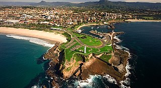
Wollongong, informally referred to as "The Gong", is a city located in the Illawarra region of New South Wales, Australia. Wollongong lies on the narrow coastal strip between the Illawarra Escarpment and the Pacific Ocean, 68 kilometres south of central Sydney. Wollongong had an estimated urban population of 302,739 at June 2018, making it the third-largest city in New South Wales after Sydney and Newcastle and the tenth-largest city in Australia by population. The city's current Lord Mayor is Gordon Bradbery AM who was elected in 2018.

Bulli is a northern suburb of Wollongong situated on the south coast of New South Wales, Australia.

Dapto is a suburb of Wollongong in the Illawarra region of New South Wales, Australia, located on the western side of Lake Illawarra and covering an area 7.15 square kilometres in size. As at the 2016 census, the suburb had a population of 10,730.

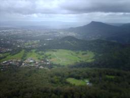
Mount Keira is a suburb and mountain in the Illawarra region of New South Wales, Australia.
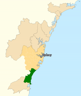
The Division of Cunningham is an Australian electoral division in the state of New South Wales.
Unanderra is a suburb of Wollongong in New South Wales, Australia. It is located approximately 10 km south-west of the Wollongong CBD. It is bordered to the west by Farmborough, Cordeaux Heights and Farmborough Heights in the Mount Kembla foothills, the north by Figtree, the east by Berkeley and Flagstaff Hill, site of the Nan Tien Temple, and the south by Kembla Grange.
Mount Pleasant is a hilly suburb in the city of Wollongong, New South Wales, Australia. It is situated on the northern flank of Mount Keira extending across to the Illawarra escarpment and is exclusively residential. It is home to the Rhododendron Park, found on Parrish Avenue. Mount Pleasant has a small local primary school Pleasant Heights Public School which has approximately 180 enrolled students. The suburb is locally notable for its commonly known Brokers Road which is amongst the steepest roads in New South Wales.

The Illawarra escarpment, or officially the Illawarra Range, is the fold-created cliffs and plateau-eroded outcrop mountain range west of the Illawarra coastal plain south of Sydney, in the state of New South Wales, Australia. The range encloses the Illawarra region which stretches from Stanwell Park in the north to Kiama, Gerringong and the Shoalhaven River in the south.

Keira is an electoral district of the Legislative Assembly in the Australian state of New South Wales. It is currently represented by Ryan Park of the Labor Party.
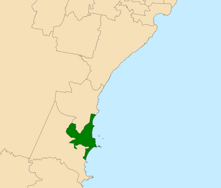
Wollongong is an electoral district of the Legislative Assembly in the Australian state of New South Wales. It is represented by Paul Scully of the Labor Party. Since a redistribution in 2013, it has covered an area of 79.25 square kilometres and includes the localities of Berkeley, Coachwood Park, Coniston, Cordeaux Heights, Corrimal, Cringila, Fairy Meadow, Farmborough Chase, Farmborough Heights, Figtree, Gwynneville, Kembla Grange, Kembla Heights, Kemblawarra, Lake Heights, Lindsay Heights, Mangerton, Mount Kembla, Mount Saint Thomas, North Wollongong, Port Kembla, Primbee, Spring Hill, Towradgi, Unanderra, Warrawong, West Wollongong, Windang, Wollongong.
Mount Nebo, a tall hill that is part of the Illawarra Range, is located in the foothills of the Illawarra escarpment on the edge of the suburban fringe of the city of Wollongong, New South Wales, Australia. At 251 metres (823 ft) above sea level, the hill is reached by the steep O'Brien's Road from the suburb of Figtree.

Figtree is an inner western suburb of Wollongong, New South Wales, Australia. It is southwest of West Wollongong and connected to Wollongong by the Princes Highway and The Avenue.

Bulli Pass is a mountain pass with an elevation of 283 metres (928 ft) AHD located northwest of Bulli, New South Wales, Australia. It is situated on the Illawarra escarpment west of the Illawarra coastal plain. It was built during the 19th century for use by loggers and locals transporting goods to and from Sydney. Beforehand sea travel was the only reliable method.
Farmborough Heights is a southern, medium-high wealth suburb in the city of Wollongong, New South Wales, Australia. It is situated to the west of Unanderra in the foothills of Mount Kembla. The suburb mainly consists of separate residential dwellings, but also has a general store. It once had a take away, though the take away and many other stores were demolished in 2010 to make room for more housing.
A fig tree is any of about 850 species of woody trees in the genus Ficus.
Mount Warrigal is a large suburb of Shellharbour, New South Wales, Australia. The population, according to the 2016 Australian Census, was 4,909. The suburb is in the Shellharbour City LGA.
Dapto High School is a government-funded co-educational comprehensive secondary day school, located in Dapto, a suburb of Wollongong in the Illawarra region of New South Wales, Australia.

Figtree High School is a government-funded co-educational comprehensive secondary day school, located on Gibsons Road in Figtree, a suburb of Wollongong, in the Illawarra region of New South Wales, Australia.
Mount Saint Thomas is a suburb of Wollongong in New South Wales, lying east of Figtree and South west of Wollongong. At the 2016 census, it had a population of 1,468.
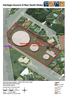
The Kiama Reservoirs are heritage-listed reservoirs at Irvine Street, Kiama, Municipality of Kiama, New South Wales, Australia. They are owned by Sydney Water. It was added to the New South Wales State Heritage Register on 15 November 2002.
References
- Shaw, 1970