
Cape Spear, located on the Avalon Peninsula near St. John's, Newfoundland, is the easternmost point in Canada (52°37'W), and North America, excluding Danish-controlled Greenland.
Baccalieu Island is a 5 km2 uninhabited island at the northern extremities of Conception Bay in Subdivision 1G, near the community of Red Head Cove, Newfoundland and Labrador, Canada. It is separated from the island of Newfoundland by Baccalieu Tickle, a small strait and an abundant fishing ground.

Cape Ray is a headland located at the southwestern extremity of the island of Newfoundland in the Canadian province of Newfoundland and Labrador.

Conche is a community on the Northern Peninsula of Newfoundland and Labrador, Canada. Its population in 2016 was 170.

Port de Grave is a peninsula on Conception Bay (CB) in Newfoundland and Labrador, Canada. The peninsula contains the communities of Bareneed, Black Duck Pond, Otterbury, Ship Cove, Blow Me Down, Hibb's Cove, Pick Eyes, and Hussey's Cove with a population of approximately 975 (2006). This community is located in the provincial electoral district of Port de Grave. An unincorporated area, for statistics purposes it is called Division No. 1, Subdivision L.
Bacalieu Island is an island off Twillingate in Newfoundland. It has a lighthouse. In 1911, it was inhabited by the lighthouse keepers and their families.
Belle Isle Northeast Light is a 27-metre (89 ft) tall, 12-sided flying buttress lighthouse located on Belle Isle, Newfoundland, which was built in 1905. It is one of three lighthouses on the island and was maintained by the Canadian Government despite the fact that Newfoundland did not join Confederation until 1949. It was designed by William P. Anderson as one in a series of nine buttressed lighthouses built in Canada around 1910.
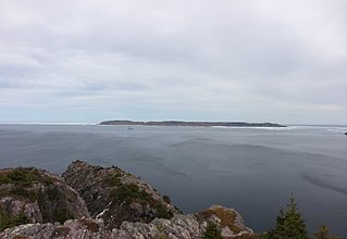
Green Island is a rocky island in the mouth of Fortune Bay, Newfoundland. It is located about 9.5 kilometres (5.9 mi) west of the Burin Peninsula of Newfoundland and 11 kilometres (6.8 mi) east of Langlade Island in Saint-Pierre and Miquelon.
Musgrave Harbour is a Canadian town in the province of Newfoundland and Labrador.
Pool's Island is an incorporated community of Badger's Quay-Valleyfield-Pool's Island in the province of Newfoundland and Labrador, Canada. It is now part of the town of New-Wes-Valley.
The Wadham Islands are a group of islands at the eastern opening to Hamilton Sound, southeast of Fogo Island off Newfoundland in the province of Newfoundland and Labrador, Canada. The islands are: Offer Wadham Islands, Copper Island, Duck Island, White Island, Peckford Island, Coleman Island, Small Island.

Cape Anguille is a headland and the westernmost point in Newfoundland, reaching into the Gulf of Saint Lawrence. It is the southern edge of St. George's Bay. Its name is derived from the nearby Cape Anguille community.

Whaleback Light is a historic lighthouse marking the mouth of the Piscataqua River between New Castle, New Hampshire and Kittery, Maine. It is located on a rocky outcrop offshore southwest of Fort Foster and south of Wood Island in Kittery. A light has been active at this location since 1820; the present tower was built in 1872. It was listed on the National Register of Historic Places in 1988.

Mount Desert Light is a lighthouse on Mount Desert Rock, a small island about 18 nautical miles south of Mount Desert Island, in the US state of Maine. The light station was established in 1830; the current lighthouse was built in 1847. It was listed on the National Register of Historic Places as Mount Desert Light Station in 1988.
William Gilbert Gosling was a Canadian politician, businessman and author. From 1916 to 1920, he served as the mayor of St. John's, Newfoundland.

Cape Race Lighthouse is an active lighthouse located in Avalon Peninsula, Newfoundland. The light's characteristic is a single white flash every 7.5 seconds, additionally a foghorn may sound a signal of two blasts every 60 seconds. It is located on one of Canada's busiest shipping lanes. The lighthouse is also a tourist attraction.
Cape Pine Light was built on Cape Pine, Newfoundland by the British architect and engineer Alexander Gordon in 1851.

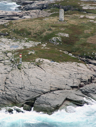
Point Riche Lighthouse, a "pepperpot" lighthouse, was built in 1892 and is still active. The white wooden tower is octagonal pyramidal in shape, the lantern room is painted red. The structure is 19 metres (62 ft) tall. Its light characteristic is a flash every 5 seconds, emitted at a focal plane height of 29 metres (95 ft). It is maintained by the Port au Choix National Historic Site.
William Austin Oke was a newspaper publisher, politician, and District Court judge in Newfoundland. He represented Harbour Grace in the Newfoundland House of Assembly for three terms, from 1898 to 1908, as a Liberal.
Division No. 1, Subdivision B is an unorganized subdivision on the Avalon Peninsula in Newfoundland and Labrador, Canada. It is in Division 1 and contains the unorganized communities of Iona, Little Barasway, Placentia Junction, Point Verde and Ship Harbour.

