Lake Huron is one of the five Great Lakes of North America. Hydrologically, it comprises the easterly portion of Lake Michigan–Huron, having the same surface elevation as its westerly counterpart, to which it is connected by the 5-mile-wide (8.0 km), 20-fathom-deep Straits of Mackinac. It is shared on the north and east by the Canadian province of Ontario and on the south and west by the state of Michigan in the United States. The name of the lake is derived from early French explorers who named it for the Huron people inhabiting the region. The Huronian glaciation was named due to evidence collected from Lake Huron region. The northern parts of the lake include the North Channel and Georgian Bay. Across the lake to the southwest is Saginaw Bay. The main inlet is the St. Marys River, and the main outlet is the St. Clair River.
The Canadian Coast Guard is the coast guard of Canada. Formed in 1962, the coast guard is tasked with marine search and rescue, communication, navigation and transportation issues in Canadian waters, such as navigation aids and icebreaking, marine pollution response and providing support for other Canadian government initiatives. The coast guard operates 119 vessels of varying sizes and 22 helicopters, along with a variety of smaller craft. The Canadian Coast Guard is headquartered in Ottawa, Ontario, and is a special operating agency within Fisheries and Oceans Canada.
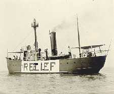
The United States lightship Huron (LV-103) is a lightvessel that was launched in 1920. She is now a museum ship moored in Pine Grove Park, Port Huron, St. Clair County, Michigan.

CCGS Limnos is a Canadian Coast Guard coastal research and survey vessel. The ship entered service in 1968 and is currently active. The ship is based on the Great Lakes at the Coast Guard Base in Burlington, Ontario and is used for hydrographic and limnological research.

Michipicoten Island is an island in Ontario, Canada, in the northeastern part of Lake Superior, about 175 kilometres (109 mi) northwest of Sault Ste. Marie and 65 kilometres (40 mi) southwest of Wawa, Ontario. At its closest point to mainland Ontario, the island is located about 16 kilometres (9.9 mi) from the mainland. It falls within the boundaries of Thunder Bay District. The third largest island in Lake Superior, Michipicoten Island is 27 kilometres (17 mi) long and 10 kilometres (6.2 mi) wide at its widest point.

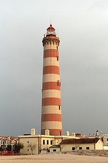
Spectacle Reef Light is a lighthouse 11 miles (18 km) east of the Straits of Mackinac and is located at the northern end of Lake Huron, Michigan. It was designed and built by Colonel Orlando Metcalfe Poe and Major Godfrey Weitzel, and was the most expensive lighthouse ever built on the Great Lakes.

East Charity Shoal Light is an offshore lighthouse located near the Saint Lawrence River's entrance in northeastern Lake Ontario, due south of the city of Kingston, Ontario and approximately five miles (8 km) southwest of Wolfe Island. It is on the southeast rim of a 3,300-foot-diameter (1,000 m) submerged circular depression known as Charity Shoal Crater that may be the remnants of a meteorite impact.

Thirty Mile Point Light is a lighthouse on the south shore of Lake Ontario in Niagara County, New York. It is part of Golden Hill State Park, a New York state park. The lighthouse is open to the public. It gets its name because it is the point 30 miles east of the Niagara River. The lighthouse was built in 1875 of hand-carved stone. The old tower is being restored.

The Stannard Rock Light, completed in 1883, is a lighthouse located on a reef that was the most serious hazard to navigation on Lake Superior. The exposed crib of the Stannard Rock Light is rated as one of the top ten engineering feats in the United States. It is 24 miles (39 km) from the nearest land, making it the most distant lighthouse in the United States. It was one of the "stag stations", manned only by men, and had the nickname "The Loneliest Place in the World".

The Detroit River Light, also known as Bar Point Shoal Light, was first established as a lightship in 1875. The current sparkplug lighthouse was built in 1885. It sits in Lake Erie, south of the mouth of the Detroit River, 1.75 nautical miles from land and about 20 nautical miles from the Ambassador Bridge in the Detroit River. It is about 0.4 nautical miles from the border with Canada, and just under 24 nautical miles from Put-in-Bay, Ohio. Its original 4th order Fresnel lens is on loan to the Michigan Maritime Museum.

Huron Island Light is a lighthouse on Lake Superior near Big Bay, Michigan. It was listed on the National Register of Historic Places as Huron Islands Lighthouse in 1975. It is on one of the Huron Islands Wilderness.

The Colchester Reef Light is an actite lighthouse situated on Colchester Reef in the Western Basin of Lake Erie south of the town of Colchester, Ontario.
Battle Island Light is a lighthouse on the Canadian shore of Lake Superior. It is located on the westerly point of Battle Island, 28.5 miles (45.9 km) east-northeast from Lamb Island Light.

The Ile Parisienne Light was built in 1911 on the southern tip of remote Ile Parisienne in the middle of Whitefish Bay on Lake Superior on a major shipping lane for ingress/egress to the Soo Locks. The lighthouse keeper's life at the remote light was lonely and perilous. It is now a well-known landmark to shipping traffic and pleasure craft. The light is automated and remains seasonally active.
The Point Abino Light Tower is a lighthouse on the rocky north shore of Lake Erie at the southern tip of Point Abino peninsula west of Crystal Beach, Ontario, Canada. The Greek Revival white square tower with red accents is attached to the fog alarm building, and a lighthouse keeper's residence is located on the shore to the north.
The Gannet Rock Lighthouse is a Canadian lighthouse located on a rocky islet 8 miles (13 km) south of Grand Manan in the Bay of Fundy. It was first lit in 1831 and was staffed until 1996. It was solarized in 2002 and remains operational in 2017. It was declared "surplus to requirements" by the Canadian Coast Guard in 2010 and is no longer being maintained.

Big Tub Lighthouse is an active lighthouse located near Tobermory in Bruce Peninsula, Ontario, Canada. The lighthouse was originally lit in 1885 and is still used up to this day.