
Craven Arms is a market town and civil parish in Shropshire, England, on the A49 road and the Welsh Marches railway line, which link it north and south to the larger towns of Shrewsbury and Ludlow respectively. The Heart of Wales railway line joins the Welsh Marches line at Craven Arms and the town is served by Craven Arms railway station. The town is enclosed to the north by the Shropshire Hills Area of Outstanding Natural Beauty, and to the south is the fortified manor house of Stokesay Castle.

Clungunford is a village and civil parish in south Shropshire, England, located near the border with Herefordshire.

Leintwardine is a small to mid-size village and civil parish in north Herefordshire, England, close to the border with Shropshire.

Stokesay is a historic hamlet in Shropshire, England just south of Craven Arms on the A49 road, also fleetingly visible from the Shrewsbury to Hereford Welsh Marches railway line.

Charlton is a village and civil parish in North Wiltshire, England, about 2 miles (3 km) northeast of Malmesbury and 4 miles (6.4 km) northwest of the village of Brinkworth. The parish includes the hamlet of Perry Green and the Charlton Park estate. The 2011 Census recorded the parish population as 425.

Fulbrook is a village and civil parish immediately northeast of Burford in West Oxfordshire. The 2011 Census recorded the parish's population as 437.

Halford is a hamlet in south Shropshire, England. It lies just east of the market town of Craven Arms, on the other side of the River Onny.

West Hanney is a village and civil parish about 3 miles (5 km) north of Wantage, Oxfordshire, England. Historically West and East Hanney were formerly a single ecclesiastical parish of Hanney. East Hanney was part of Berkshire until the 1974 boundary changes transferred the Vale of White Horse to Oxfordshire. The 2011 Census recorded the parish's population as 490.

Culmington is a village and civil parish in south Shropshire, England, about 3+1⁄2 miles (5.6 km) east of Craven Arms and 4+1⁄2 miles (7 km) north of Ludlow. The village is about 330 feet (100 m) above sea level, beside the River Corve, just east of the B4365 road. The 2011 Census recorded the parish population as 423.
Westcott Barton, also spelt Wescot Barton or Wescote Barton, is a village and civil parish on the River Dorn in West Oxfordshire about 7 miles (11 km) east of Chipping Norton and about 9+1⁄2 miles (15 km) south of Banbury. The parish is bounded to the north by Cockley Brook, a tributary of the River Dorn. A minor road to Kiddington forms part of the eastern boundary, another minor road forms part of the western boundary and the remainder of the parish boundaries are field boundaries. Westcott Barton's main area of housing is on the eastern boundary of the parish and contiguous with the village of Middle Barton in the neighbouring parish of Steeple Barton. The 2011 Census recorded the parish's population as 244.

St Mary's Church is in the village of Acton Burnell, Shropshire, England, and stands near the ruins of Acton Burnell Castle. It is an active Anglican parish church in the deanery of Condover, the archdeaconry of Ludlow, and the diocese of Hereford. Its benefice is united with those of St Andrew and St Mary, Condover, St Mark, Frodesley, and St Michael and All Angels, Pitchford. The church is recorded in the National Heritage List for England as a designated Grade I listed building.

St Mary the Virgin's Church is a former priory church located in the village of Bromfield, Shropshire, England. It is an active Anglican parish church in the deanery of Ludlow, the archdeaconry of Ludlow, and the diocese of Hereford. Its benefice is united with those of 5 other parishes to form the Bromfield Benefice. The church is recorded in the National Heritage List for England as a designated Grade I listed building.

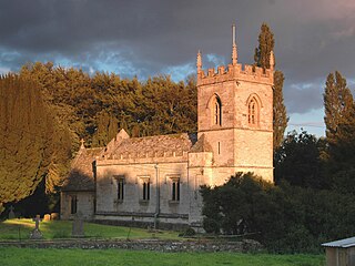
St James' Church stands in an elevated position in the village of Cardington, Shropshire, England. It is an active Anglican parish church in the deanery of Condover, the archdeaconry of Ludlow, and the diocese of Hereford. The church is recorded in the National Heritage List for England as a designated Grade I listed building.

St Peter's Church is in the village of Chelmarsh, Shropshire, England. It is an active Anglican parish church in the deanery of Bridgnorth, the archdeaconry of Ludlow, and the diocese of Hereford. Its benefice is united with those of seven other churches to form the benefice of Highley with Billingsley, Glazeley and Deuxhill, and Chelmarsh. The church is recorded in the National Heritage List for England as a designated Grade I listed building.

St Laurence's Church is in Church Street, Church Stretton, Shropshire, England. It is an active Anglican parish church in the deanery of Condover, the archdeaconry of Ludlow, and the diocese of Hereford. Its benefice is united with those of St Michael and All Angels, All Stretton, and All Saints, Little Stretton to form the parish of Church Stretton. The church is recorded in the National Heritage List for England as a designated Grade I listed building.
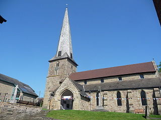
St Mary's Church is on Church Street, Cleobury Mortimer, Shropshire, England. It is an active Anglican parish church in the deanery of Ludlow, the archdeaconry of Ludlow, and the diocese of Hereford. Its benefice is united with those of six local parishes to form the Cleobury Benefice. The church is recorded in the National Heritage List for England as a designated Grade I listed building. It is notable for its shingled twisted spire.
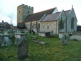
St Swithun's Church is in the village of Clunbury, Shropshire, England. It is an active Anglican parish church in the deanery of Clun Forest, the archdeaconry of Ludlow, and the diocese of Hereford. Its benefice is united with those of St Mary, Bedstone, St Cuthbert, Clungunford, St Mary, Clunton, and St Edward, Hopton Castle. The church is recorded in the National Heritage List for England as a designated Grade I listed building.
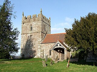
Holy Trinity Church is in the village of Holdgate, Shropshire, England. It is an active Anglican parish church in the deanery of Ludlow, the archdeaconry of Ludlow, and the diocese of Hereford. Its benefice is united with those of St Peter, Diddlebury, Broadstone Church, St Michael, Munslow, and St Catherine, Tugford. The church is recorded in the National Heritage List for England as a designated Grade I listed building. It stands in the former southwest bailey of Holdgate Castle.

Munslow is a hundred of Shropshire, England. It was formed with the amalgamation of the Anglo-Saxon hundreds of Patton and Culvestan during the reign of Henry I. Hundreds in England had various judicial, fiscal and other local government functions, their importance gradually declining from the end of manorialism to the latter part of the 19th century.
Culvestan was a hundred of Shropshire, England. Formed during Anglo-Saxon England, it encompassed manors in central southern Shropshire, and was amalgamated during the reign of Henry I with the neighbouring hundred of Patton to form the Munslow hundred.


