Orefield, Pennsylvania

Last updated

Orefield, Pennsylvania
Unincorporated community
Orefield, Pennsylvania (8483423166).jpg
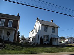
Homes in Orefield in January 2013
USA Pennsylvania location map.svg
Red pog.svg
Orefield
Location of Orefield in Pennsylvania
Coordinates: 40°38′05″N75°35′04″W / 40.63472°N 75.58444°W / 40.63472; -75.58444
Country Flag of the United States.svg  United States
State Flag of Pennsylvania.svg  Pennsylvania
County Lehigh
Township North Whitehall and South Whitehall
Elevation
138 m (453 ft)
Population
   Metro
865,310 (US: 68th)
Time zone UTC-5 (Eastern (EST))
  Summer (DST) UTC-4 (EDT)
ZIP code
18069
Area code(s) 610 and 484
GNIS feature ID1183034 [1]
Primary airport Lehigh Valley International Airport
Major hospital Lehigh Valley Hospital–Cedar Crest
School district Parkland

Orefield is a small unincorporated community in Lehigh County, Pennsylvania. The community is split between North Whitehall and South Whitehall townships. Orefield is part of the Lehigh Valley, which has a population of 861,899 and is the 68th-most populous metropolitan area in the U.S. as of the 2020 census.

Contents

Located along Pennsylvania Route 309, Orefield has the ZIP Code of 18069. Its name is derived from the extensive deposits of limonite (iron ore) once mined here. It was once the terminus of the Siegersville Branch of the Ironton Railroad, which was extended here to haul the ore. Orefield is the former home to Parkland High School. It is located outside of Allentown. Orefield is surrounded by many suburban housing developments, many of which were former farms operated by the Pennsylvania Dutch whose influence in the community is waning. Several covered bridges nearby cross the Jordan Creek.

Located near Orefield is a large factory for Alpo a dog food company, which has been owned by the Ralston Purina Company since the 1990s. Also located nearby are the Jaindl turkey farms; Orefield's turkey farms provide the already-slaughtered turkeys that are presented to the president of the United States each Thanksgiving; the live turkeys that are pardoned at the same presentation come from rotating locations). [2] [3] Located in Orefield is Shankweiler's Drive-In Theatre, the second drive-in ever built (1934) and America's oldest operating drive-in theater.

Education

Orefield is served by the Parkland School District, which has Orefield Middle School in the village. The district's high school was located in Orefield until 1999, when it moved to Cedar Crest Boulevard to the east. Kernsville Elementary School is located just west of the village. Students in grades nine through 12 attend Parkland High School, the state's fourth-largest public high school, in South Whitehall Township.

Notable residents

Related Research Articles

<span class="mw-page-title-main">Lehigh County, Pennsylvania</span> County in Pennsylvania, United States

Lehigh County is a county in the Commonwealth of Pennsylvania. As of the 2020 census, the county's population was 374,557. Its county seat is Allentown, the state's third-largest city after Philadelphia and Pittsburgh.

<span class="mw-page-title-main">Emmaus, Pennsylvania</span> Borough in Pennsylvania, United States

Emmaus is a borough in Lehigh County, Pennsylvania, United States. As of the 2020 U.S. census, it had a population of 11,652. Emmaus is located in the Lehigh Valley, the third-largest metropolitan area in Pennsylvania and 68th-largest metropolitan area in the nation.

<span class="mw-page-title-main">North Whitehall Township, Pennsylvania</span> Township in Pennsylvania, United States

North Whitehall Township is a township in Lehigh County, Pennsylvania, United States. The population of North Whitehall Township was 15,655 at the 2020 census. It is a suburb of Allentown in the Lehigh Valley, which had a population of 861,899 and was the 68th-most populous metropolitan area in the U.S. as of the 2020 census.

<span class="mw-page-title-main">Schnecksville, Pennsylvania</span> Census-designated place in Pennsylvania, United States

Schnecksville is an unincorporated community and census-designated place (CDP) in North Whitehall Township in Lehigh County, Pennsylvania. The population of Schnecksville was 2,935 at the 2010 census.

<span class="mw-page-title-main">South Whitehall Township, Pennsylvania</span> Township in Pennsylvania, United States

South Whitehall Township is a township in Lehigh County, Pennsylvania, United States. The township's population was 19,180 at the 2010 census. It is a suburb of Allentown and is part of the Lehigh Valley, which had a population of 861,899 and was the 68th-most populous metropolitan area in the U.S. as of the 2020 census.

<span class="mw-page-title-main">Upper Macungie Township, Pennsylvania</span> Township in Pennsylvania, United States

Upper Macungie Township is a township in Lehigh County, Pennsylvania, United States. The population of Upper Macungie Township was 26,377 as of the 2020 U.S. census, making it the fourth-fastest growing municipality of any category in Pennsylvania in terms of total population growth between 2010 and 2020.

<span class="mw-page-title-main">Whitehall Township, Pennsylvania</span> Township in Pennsylvania, United States

Whitehall Township is a township with home rule status in Lehigh County, Pennsylvania, United States. The township's population was 26,738 as of the 2010 census.

<span class="mw-page-title-main">Palmer Township, Pennsylvania</span> Second Class Township in Pennsylvania, United States

Palmer Township is a township in Northampton County, Pennsylvania, United States. The population of Palmer Township was 22,317 at the 2020 census. It is the eight-largest municipality in the Lehigh Valley metropolitan area, which had a population of 861,899 and was the 68th-most populous metropolitan area in the U.S. as of the 2020 census.

<span class="mw-page-title-main">Breinigsville, Pennsylvania</span> Census-designated place in Pennsylvania, United States

Breinigsville is an unincorporated community and census-designated place (CDP) in Lehigh County, Pennsylvania. As of the 2020 census, it had a population of 7,495. The town is part of Upper Macungie Township and is located approximately 11 miles (18 km) southwest of downtown Allentown and 8 miles (13 km) east of Kutztown.

<span class="mw-page-title-main">Trexlertown, Pennsylvania</span> Census-designated place in Pennsylvania, United States

Trexlertown is an unincorporated community and census-designated place (CDP) in Upper Macungie Township in Lehigh County, Pennsylvania. As of the 2020 census, the population was 2,382. It is part of the Lehigh Valley, which had a population of 861,899 and was the 68th-most populous metropolitan area in the U.S. as of the 2020 census, and lies between Breinigsville and Wescosville.

<span class="mw-page-title-main">National Thanksgiving Turkey Presentation</span> Feast ritual held in the United States

The National Thanksgiving Turkey Presentation is a ceremony that takes place at the White House every year shortly before Thanksgiving. The president of the United States is presented with a live domestic turkey by the National Turkey Federation (NTF), usually males of the Broad Breasted White variety. The early years also included a joint presentation with the Poultry and Egg National Board. The ceremony dates back to the 1940s; these turkeys were usually slaughtered and eaten prior to the 1970s, when it became standard practice to spare the turkey. During the presidency of George H. W. Bush, it became a tradition for the president to issue a ceremonial "pardon" to the turkey. It is a tradition that the turkeys be picked from the chairperson of the NTF's home state, occasionally from the chair's own farm.

<span class="mw-page-title-main">Parkland School District</span> School district in Pennsylvania

Parkland School District is a large public school district located in the Lehigh Valley region of eastern Pennsylvania. It serves North Whitehall Township, South Whitehall Township, Upper Macungie Township, and part of western Allentown. The district also includes the following census-designated places in South Whitehall Township: Cetronia, and the township's portion of Dorneyville. The district also includes the South Whitehall communities of Orefield, Scherersville, Walbert, and others.

<span class="mw-page-title-main">Parkland High School (Pennsylvania)</span> Public high school in Allentown, Pennsylvania, United States

Parkland High School is a large public high school in South Whitehall Township, Pennsylvania, near Allentown. The school serves students in grades 9–12 and is the only high school in Parkland School District.

The Lehigh Valley Interscholastic Athletic Conference, known informally as the Lehigh Valley Conference or LVC, was an athletic conference consisting of 12 of the largest high schools from Lehigh and Northampton counties in the Lehigh Valley region of Pennsylvania. It was part of District XI of the Pennsylvania Interscholastic Athletic Association (PIAA). In 2014, its teams were mostly assimilated into the Eastern Pennsylvania Conference, an even larger 18-team league of the largest high schools in the Lehigh Valley and Pocono Mountains regions of eastern and northeastern Pennsylvania.

<span class="mw-page-title-main">Whitehall High School (Pennsylvania)</span> Public high school in Whitehall Township, Lehigh County, Pennsylvania, United States

Whitehall High School is a public high school based in Whitehall Township in the Lehigh Valley region of eastern Pennsylvania. It is the only high school in the Whitehall-Coplay School District. As of the 2022–23 school year, the school had an enrollment of 1,459 students, according to National Center for Education Statistics data.

<span class="mw-page-title-main">Egypt, Pennsylvania</span> Census-designated place in Pennsylvania, United States

Egypt is an unincorporated community and census-designated place (CDP) in Whitehall Township in Lehigh County, Pennsylvania, United States. The population of Egypt was 2,588 as of the 2020 census.

<span class="mw-page-title-main">Laurys Station, Pennsylvania</span> Census-designated place in Pennsylvania, United States

Laurys Station is an unincorporated community and census-designated place (CDP) in North Whitehall Township in Lehigh County, Pennsylvania. It is part of the Lehigh Valley, which had a population of 861,899 and was the 68th-most populous metropolitan area in the U.S. as of the 2020 census. It is located approximately 9 miles (14 km) north of Allentown and about 6 miles (10 km) southeast of Walnutport.

West Catasauqua is an unincorporated village in Whitehall Township in Lehigh County, Pennsylvania. Once a port and station along the busy Lehigh Canal, it is colloquially known as West Catty. It is part of the Lehigh Valley, which has a population of 861,899 and is the 68th-most populous metropolitan area in the U.S. as of the 2020 census.

Scherersville is an unincorporated community in Lehigh County, Pennsylvania. It is located on Jordan Creek, mainly in South Whitehall Township and also in Whitehall Township. Schereresville is part of the Lehigh Valley, which has a population of 861,899 and is the 68th-most populous metropolitan area in the U.S. as of the 2020 census.

<span class="mw-page-title-main">Balliettsville, Pennsylvania</span> Unincorporated community in Pennsylvania, United States

Balliettsville is an unincorporated community in North Whitehall Township in Lehigh County, Pennsylvania. It is part of the Lehigh Valley, which had a population of 861,899 and was the 68th-most populous metropolitan area in the U.S. as of the 2020 census.

References

  1. "Orefield". Geographic Names Information System . United States Geological Survey, United States Department of the Interior.
  2. "Trump will pardon his first turkey next week". CBS News. November 16, 2017. Retrieved November 17, 2017.
  3. "President Trump Welcomes NTF & National Thanksgiving Turkey to the White House". PR Newswire. November 25, 2019. Retrieved November 27, 2019.