
Nevada City is the county seat of Nevada County, California, United States, 60 miles (97 km) northeast of Sacramento, 84 miles (135 km) southwest of Reno and 147 miles (237 km) northeast of San Francisco. The population was 3,068 as of the 2010 Census.

The Gold Country is a historic region in the northern portion of the U.S. state of California, that is primarily on the western slope of the Sierra Nevada. It is famed for the mineral deposits and gold mines that attracted waves of immigrants, known as the 49ers, during the 1849 California Gold Rush.

Malakoff Diggins State Historic Park is a state park unit preserving the largest hydraulic mining site in California, United States. The mine was one of several hydraulic mining sites at the center of the 1882 landmark case Woodruff v. North Bloomfield Mining and Gravel Company. The mine pit and several Gold Rush-era buildings are listed on the National Register of Historic Places as the Malakoff Diggins-North Bloomfield Historic District. The "canyon" is 7,000 feet (2,100 m) long, as much as 3,000 feet (910 m) wide, and nearly 600 feet (180 m) deep in places. Visitors can see huge cliffs carved by mighty streams of water, results of the mining technique of washing away entire mountains of gravel to wash out the gold. The park is a 26-mile (42 km) drive north-east of Nevada City, California, in the Gold Rush country. The 3,143-acre (1,272 ha) park was established in 1965.

State Route 49 is a north–south state highway in the U.S. state of California that passes through many historic mining communities of the 1849 California gold rush and it is known as the Golden Chain Highway. The highway's creation was lobbied by the Mother Lode Highway Association, a group of locals and historians seeking a single highway to connect many relevant locations along the Gold Rush to honor the 49ers. One of the bridges along SR 49 is named for the leader of the association, Archie Stevenot.

Empire Mine State Historic Park is a state-protected mine and park in the Sierra Nevada mountains in Grass Valley, California, U.S. The Empire Mine is on the National Register of Historic Places, a federal Historic District, and a California Historical Landmark. Since 1975 California State Parks has administered and maintained the mine as a historic site. The Empire Mine is "one of the oldest, largest, deepest, longest and richest gold mines in California". Between 1850 and its closure in 1956, the Empire Mine produced 5.8 million ounces of gold, extracted from 367 miles (591 km) of underground passages.
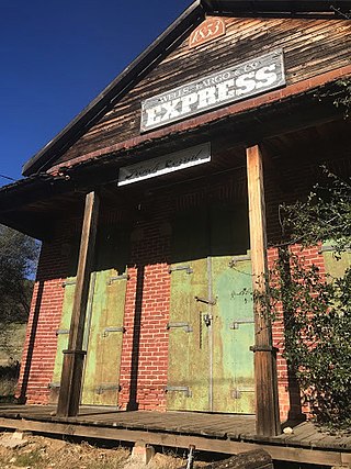
French Corral is an unincorporated community approximately five miles west of California State Highway 49 in Nevada County, California, United States.

The North Bloomfield Mining and Gravel Company of North Bloomfield, California, was established in 1866 and operated a hydraulic gold-mining operation at the Malakoff Mine subsequent to the California Gold Rush. In its day, no other company's operations matched North Bloomfield Mining and Gravel Company in size or expense. The company operated until 1910. In the years prior, its profits and procedures had been reduced due to the landmark ruling of Woodruff v. North Bloomfield Gravel Mining Company.
Orleans Flat was a historic mining town located on the San Juan Ridge about 20 miles northeast of Nevada City, California and about 5 miles northeast of North Bloomfield, California. The town was about 1 mile south of the Middle Yuba River at an elevation of about 4200 ft. To the west lay the mining towns of Moore's Flat and Woolsey's Flat, each about I mile apart. All three were settled around 1851 and their histories frequently intertwine. Collectively, they are sometimes referred to as "The Flats." All three were part of Eureka Township.
Snow Point was a historic mining town in Nevada County, California on the San Juan Ridge about 2 miles east of Moore's Flat and about 6 miles west of Graniteville. It was located at an elevation of 4321 ft just off present day German Bar Road about midway between that road's intersections with present day Moore's Flat Road and Hagerty Road.
Alpha was a gold mining town in Nevada County, located about 2 miles southeast of the town of Washington, California and about 15 miles northeast of Nevada City, California. It lay at an elevation of 4120 feet, about 2 miles below the South Yuba River and just west of Scotchman Creek.

Blue Tent is a historic 19th century gold mining community located about six miles northeast of Nevada City, California.
Cherokee is a former gold mining community in Nevada County, California. As explained below, it has also been known as Patterson, Melrose and Tyler. It is located on the San Juan Ridge about 4 miles east of North San Juan. Its elevation is 2,516 ft (767 m) above sea level.
Red Dog was a California gold rush mining town located in the Gold Country in south-central Nevada County, California, United States, 6 mi (9.7 km) northeast of Chicago Park. Red Dog Hill, a mine and campsite, was founded by three men all under the age of 22, and was named by their youngest, a 15-year-old prospector. As mining operations grew, the campsite became a settlement, and then a town with a population of 2,000 residents, before it was eventually abandoned. Still considered important today, Red Dog Townsite is listed on the National Register of Historic Places.

The South Yuba Canal Office was the headquarters for the largest network of water flumes and ditches in California. It is located at 134 Main Street, Nevada City, California, USA.

Meadow Lake was a historic mining town in Nevada County, California. It was located on the southwest shore of Meadow Lake, about 18 miles northwest of Truckee as the crow flies. Situated at an elevation of 7,290 ft (2,220 m) above sea level, the reservoir of the same name is one of the highest lakes in elevation within the Tahoe National Forest.
Mooney Flat was an important mining and transportation hub in western Nevada County, California, just east of the Yuba County line. It was situated on modern Mooney Flat Road, about 1 mile north of modern Highway 20, at an elevation of about 800 ft.
The North Star Mine and Powerhouse are located on Lafayette Hill a short distance south of Grass Valley in the U.S. state of California. It was the second largest producer of gold during California's Gold Rush. In 1898, the largest Pelton wheel for its time was built for the mine. The North Star Mine Company also owned locations on Weimar Hill, adjoining and south of the North Star Mine. It shut down during World War II after its consolidation with the Empire Mine.

The Nevada City Downtown Historic District is a 16-acre (6.5 ha) historic district in Nevada City within the U.S. state of California. Located in Nevada County, it was listed on the National Register of Historic Places in 1985. It dates from 1917, with examples of Moderne and Italianate architecture. The period of significance is 1856-1917. The historic district covers the downtown section roughly bounded by Spring, Bridge, Commercial, York, Washington, Coyote, and Main Streets. It includes 70 contributing buildings including the National Hotel, which is separately listed on the National Register. Several historical buildings have received California Historical Landmark status, and have been preserved.

The Independence Trail is located approximately 7 miles from downtown Nevada City within the South Yuba River State Park in the Sierra Nevada foothills within Nevada County, in Northern California. The trail is the former Excelsior Ditch, which was found and repaired by John Olmsted and a large group of local volunteers. It is notable for being the first ADA approved wheelchair nature trail. It topped the list of "favorite trails for 2013" in The Sacramento Bee newspaper.


