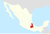
Pahuatlán (Spanish:[pawaˈtlan]ⓘ), officially Pahuatlán del Valle, is a town and municipality located in the northwest of the state of Puebla in central Mexico. The municipality is part of the Sierra Norte region of the state, a steep mountainous area which receive significant moisture from the Gulf of Mexico, and borders the states of Hidalgo and Veracruz.
The town was founded by the Augustinians when they built a small monastery in the town in 1532, with the area divided among ethnic Nahuas and Otomis, both of which can still be found here today. Culturally, the municipality is best known for the amate bark paper which is produced by the Otomis of the San Pablito community.
The town
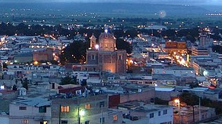
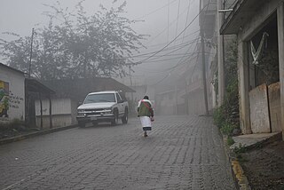
The town of Pahuatlán is located on a small level space on the side of the Ahila Mountain about 1600 meters above sea level in the Sierra Norte mountains of Puebla about fifty km from Tulancingo near the Hidalgo and Veracruz state borders.[1][2][3] It is the center of commerce for the municipality of the same name, with a population of just over 3,000.[2] The area conserves most of its traditional simple and austere architecture despite the lack of ordinances to that effect. The center of the town has stone paved roads. Traditional houses consist of two floors with wrought iron balconies and high roofs covered in red tile.[1][3][4] The town has been photographed by noted artist Angeles Torrejon for a series called “Vivir en la Sierra” (To live in the mountains). Another regular photographer of the area is Ruben Pax.[5]
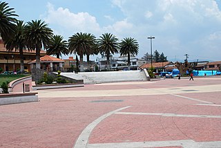
The historic center of the town is its main plaza, which serves as a tianguis market on Sundays, selling handcrafts such as rebozos, other textiles, fresh flowers, ceramics, leather goods and more, mostly from the surrounding rural communities.[5]
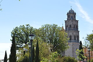
This plaza is surrounded by the main civic and religious structures of the area, such as the municipal palace.[3] The main monumental structure in the municipality is the Santiago Apóstol parish from the 16th century. The patron saint of the municipality is the Apostle James the Great, whose feast day is celebrated on 25 June here with masses, processions, fireworks and traditional dance including the Voladores.[2]
View of the parish church
The Casa de Cultura has paintings and literature related to the municipality.[2]
The main handcrafts store is the Casa del Amate (House of Amate Paper) located on the main road heading towards the town center. In addition to selling the local paper, it also sells embroidered items and paintings.[5] It was the workshop of painter Rafael Lechuga, whose art depicts the area and the local amate paper.[3]
The Parque de los Muertos, according to tradition, is where soldiers loyal to Maximilian I were buried.[4]
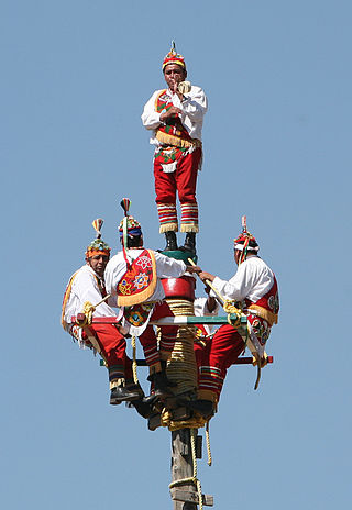
The most traditional music of the area is huapango. Traditional dress for women includes a long black skirt with a white embroidered blouse and rebozo or quezquémetl. For men, it includes undyed cotton pants and shirt, a palm leaf hat, sandals and a machete. Traditional dishes of the area include mole poblano, pipián, tamales, fresh water shrimp and a type of ant called chicales.[2] At night, a traditional snack is “molletes,” French bread with refried beans, longaniza sausage and cheese which is toasted.[3] Pahuatlán is one of a number of communities that claims to be the origin of the Danza de los Voladores.[3] It hosted the fourth Danza de los Voladores ( International Encounter in 1998. The spectacle is mostly performed by the Nahuas in the area.[6]
It is a weekend getaway for residents of Tulancingo.[1] There are two main hotels, one with three stars and the other with one. There are also a number of small guesthouses operated by families in their homes.[7] Locally produced coffee is available in the town's stores.[5]
Carnival lasts for the eight days prior to Ash Wednesday to mark the end of “mundane life” in preparation for Lent and Holy Week. Participants are men dressed in multicolored outfits and wood masks who dance in the streets accompanied by live or recorded music. These are known as the “Huehues of Pahuatlán.” The municipality supports the annual event in several ways including workshops for the making and improving of costumes and masks.[8]
Pahuatlán major festival is during Holy Week, which attracted an estimated 8,000 people in 2008. Religious events are complemented by the annual Festival Cultural de la Sierra which sponsors plays art exhibits and more.[1][7]
Another important celebration marks the victory of General Lechuga's forces of the French, celebrated in January.[2]
The town held its first film festival called the Encuentro Nacional de Festivales de Cine in 2012, sponsored by the Centro Internacional de Artes y Ciencias (Cinearte) and the Festival Internacional de Cine de Puebla (FICP).[9]
The municipality
View of the main street in San PablitoView of the Pahuatlán Valley
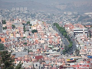
The town of Pahuatlán is the seat of government for the municipality of the same name, which contains a population of 20,619 as of 2010, divided into thirty four communities.[2][10] Together, the communities form an area of 80.37km2, nestled in the far northwest of the state of Puebla, bordering the Sierra Otomí-Tepahua mountains of Hidalgo.[1] The municipality borders the municipalities of Tlacuilotepec, Naupan and Honey, bordering the state of Hidalgo on the north, south and west.[2] All of the communities of the municipality are classified as rural, with the exception of the seat and San Pablito.[10] The municipal government consists of a municipal president, an officer called a “síndico” and seven representatives called “regidores.”[2]
The municipality is in the south of a cultural region known as La Huasteca.[11] Just under half of the population is indigenous, divided between ethnic Nahua and ethnic Otomí.[4][10]
Amate paper wall hangings at the Gallery/Museum in San Pablito
After the town of Pahuatlán, the most populous community is San Pablito, with 2,760 people on a level area on the side of the Cerro del Guajalote Mountain near the Cerro del Brujo. Its Otomi name is Bite (meaning “below the mountain”).[2][3][12] It is separated from the municipal seat by twelve km, and a deep ravine cut by the San Marcos River.[2][13] The main economic activity here is handcrafts, especially the production of a paper called “amate” made from the bark of a kind of fig tree that grows in the area.[2][3] The creation of this paper dates back to the pre Hispanic period and was and is used by the shamans of the area in rituals.[3] The small town is the principal producer of amate paper in Mexico.[14] The paper is mostly made by women in their homes and is sold to artists and artisans all over the world. Most is bought by Nahua painters from the state of Guerrero.[3] On days when the paper is being manufactured, it is possible to hear the rhythmic thumping of stones pounding the fibers through the town. The production of the paper has caused environmental problems such as the overstripping of trees for bark and the use of chemicals which wind up in the Cazones River. The problematic chemicals are caustic soda, used to soften the bark and industrial dyes.[14]
The Fiesta del Pueblo or Town Festival occurs annually in San Pablito. It begins the week after Holy Week ends and lasts for fifteen days. Twelve saints are honored during this time, with each having his or her own day. The most important of these days is that dedicated to the Holy Trinity with the day honoring the towns patron saint, Saint Paul, coming second.[12] San Pablito also is known for its colorful celebrations of Day of the Dead. This lasts from 31 October to 2 November, with different days dedicated to children, adults and saints.[11]
Cuauneutla is one of the oldest communities in the municipality.[15] It is located thirteen km from the municipal seat with a population of just over 700. Its main economic activity is the production of coffee.[2] In February, the community of Cuauneutla celebrates its patron, the Señor de la Agonía (Lord of Agony) with cultural, religious, sporting and social events.[15]
Xolotla is located about 14km from the municipal seat with a population of about 2,400 people. Its main economic activity is embroidery and other handcrafts. Atla is located about ten km from the municipal seat with a population of about 1,700 people. Its main economic activity is agriculture, especially the growing of coffee along with some handcrafts. Tlalcruz de Libres is located about 12km from the municipal seat with a population of just over 1,000 people. Its main economic activity is agriculture, especially the growing of coffee. Zoyatla de Guerrero is located about twelve km from the municipal seat with a population of under 1000. Its main economic activity is the growing of coffee. Atlantongo is located about 18km from the municipal seat with a population of about 680. Its main economic activity is the growing of chili peppers along with crafts.[2]
Pahuatlán's main hospital is located down in the valley area near the river. It was opened in 2000, replacing a clinic built in 1970. It has a capacity of twelve beds and an emergency room. Flooding and shifting earth has damaged the structures with noticeable cracks in its walls. Much of the damage occurred in 2006 and 2007 as a result of Hurricanes Dean and Karl.[16]
History
The name comes from Nahuatl and means “place of avocados” or “place of fruit.” Its Otomi name is “Matsooni,” which is derived from the word for avocado.[2][17]
During the pre Hispanic era, the area was inhabited by various ethnicities including the Nahuas, Otomis and Totonacas. The Aztec Empire invaded the area and nominally held it until the Spanish arrived, but the rich resources of the area were in dispute between the local Otomi and Nahua peoples.[2][4] The Spanish took over the area in 1522 and imposed the encomienda system.[2] The first evangelists to the area were the Augustinians. They founded a small monastery in 1532, where the parish church, built in 1652, is found now.[3] This is considered to be the founding of the town of Pahuatlán.[4] The area come under the direct rule of the Spanish Crown in the 17th century. By 1750, it came under the jurisdiction of Huauchinango and remained so until 1860.[2]
The major historical event to happen in this area occurred during the French Intervention in Mexico. On 28 January 1865, a battle occurred here between the French and their backers against troops under Coronel José Luis Lechuga.[2]
In 1861, the municipality's official name was changed to Pahuatlán del Valle to honor General Don Leandro Valle.[2]
As the town of Pahuatlán is located on the side of a steep hill, it is prone to landslides and other consequences of erosion. In October 2007, a fault line 800 meters long opened on one side of the town, causing the evacuations of over eighty families.[18] This negatively affected tourism in the area for a time.[7]
The municipal seat has applied to become a Pueblo Mágico in order to attract tourism to the area. To be accepted the state government invested 50 million pesos in social infrastructure. This included the reconstruction and widening of the Atlantongo-Xolotla highway, which cost over 20 million pesos.[19]
Geography
Steep mountainsides of the Sierra Norte of Puebla around PahuatlánView of the San Marcos River
Mountains
Pahuatlán is in the northwestern Sierra Norte of Pueblamountain range, at the intersection of the Trans-Mexican Volcanic Belt and the Sierra Madre Oriental, between the Mexican Plateau and the Gulf of Mexico coast. This area consists of a series of many individual mountain peaks formed in parallel lines. These mountains are separated by narrow valleys which frequently slope down towards the Gulf of Mexico. The terrain is steep and irregular with much of the municipality following the San Marcos and Mamiquetla rivers. Major peaks include the El Chile, Toxtla, Blanco, Tlazalotepec, De la Cruz, and Batalla de 28 Enero. The elevation of the municipality varies from 600–2,000 metres (2,000–6,600ft) above sea level.[2]
Climate
There are two main climates in the municipalities, the temperate of the higher Sierra Norte and the hotter climate of the lower elevations nearer to the Gulf of Mexico The temperate climate has average annual temperatures which range from 12 to 18C. Most of the municipality falls under this designation. A small portion is in a semi hot climate with an average annual temperature of over 18C.[2]
Both climates are humid, receiving large quantities of moist air from the Gulf,[2] with the municipalities one of the most moist areas in the Sierra Norte of Puebla.[4] The steep terrain and wet weather of the area makes its prone to landslides and the opening of cracks in the ground.[18] In 1999, a twenty-meter fissure opened after a period of rain.[20] In 2007, a fault line opened in the ground for 800 meters from the municipal palace to Leandro Valle Schools, provoking several landslides and mandatory evacuations of over eighty families.[18] About four tons of earth and debris moved as a result.[20]
Natural history
The area is part of several river basins which are all tributaries of the Gulf of Mexico. The rivers here are relatively recent in formation, winding with a number of steep drops. The two largest river basins are those of the Cazones and Tuxpan rivers with the principle water flows being the Mamiquetla, the Cuarco, Los Marías, Trinidad, Honey, Alcalman, Pahuatitla and Chixtla. Several of these eventually form the San Marcos, the main tributary of the Cazones.[2]
Most of the municipality's natural vegetation ecosystems have been eliminated. Some forests at the highest elevations remain, of the Sierra Madre Oriental pine-oak forests ecoregion. The lower elevations generally have only shrubs and other low growing vegetation. One major forest area is the perennial rainforest on the edges of the San Marcos River. Where natural vegetation still exists, wildlife such as deer, rabbits and opossum along with various bird and reptiles species are found.[2]
There are caves at Angeles Tlacuilotepec, El Saltillo and Cazones, with cave paintings in the area between the Atla and Xolotla communities as well as a small archeological site at Saltillo.[2]
Socioeconomics
Most of the municipality's residents lives in a state of socioeconomic marginalization, with thirty one communities classified as highly marginalized and two as very highly marginalized.[10] The main economic activities are farming, especially coffee and the making of handcrafts, with commerce concentrated in the town of Pahuatlán proper.[2]
The municipality is Mexico's main producer of amate bark paper, with its production concentrated in the community of San Pablito.[14] Other handcrafts include hats, necklaces, embroidered clothing, baskets, semi precious stones and the weaving of wool.[2] The Museo de Arte Popular has sponsored a different craft for the area, the creation of beaded bands. The production and sale of these bands is not only to help support the artisan community of Pahuatlan but also to earn money for other museum projects.[21]
However, despite this, most of the area's youth migrate to the United States for employment.[14] This has left the area with mostly women. The economic recession of 2009 in the United States had a significant negative impact in the area with remittances sent back cut.[22]
Although the area is not well known to tourists,[5] efforts have been made to bring tourism to the municipality, principally through efforts to get the town of Pahuatlán designated as a “Pueblo Mágico.”[19]
Related Research Articles
Hidalgo, officially the Free and Sovereign State of Hidalgo, is one of the 31 states which, along with Mexico City, constitute the 32 federal entities of Mexico. It is divided into 84 municipalities and its capital city is Pachuca de Soto. It is located in east-central Mexico and is bordered by San Luis Potosí and Veracruz on the north, Puebla on the east, Tlaxcala and State of Mexico on the south and Querétaro on the west.
Puebla, officially Free and Sovereign State of Puebla, is one of the 32 states which comprise the Federal Entities of Mexico. It is divided into 217 municipalities and its capital is the city of Puebla.
Totonacapan refers to the historical extension where the Totonac people of Mexico dominated, as well as to a region in the modern states of Veracruz and Puebla. The historical territory was much larger than the currently named region, extending from the Cazones River in the north to the Papaloapan River in the south and then west from the Gulf of Mexico into what is now the Sierra Norte de Puebla region and into parts of Hidalgo. When the Spanish arrived, the Totonac ethnicity dominated this large region, although they themselves were dominated by the Aztec Empire. For this reason, they allied with Hernán Cortés against Tenochtitlán. However, over the colonial period, the Totonac population and territory shrank, especially after 1750 when mestizos began infiltrating Totonacapan, taking political and economic power. This continued into the 19th and 20th centuries, prompting the division of most of historical Totonacpan between the states of Puebla and Veracruz. Today, the term refers only to a region in the north of Veracruz where Totonac culture is still important. This region is home to the El Tajín and Cempoala archeological sites as well as Papantla, which is noted for its performance of the Danza de los Voladores.
Amate is a type of bark paper that has been manufactured in Mexico since the precontact times. It was used primarily to create codices.
The Danza de los Voladores, or Palo Volador, is an ancient Mesoamerican ceremony/ritual still performed today, albeit in modified form, in isolated pockets in Mexico. It is believed to have originated with the Nahua, Huastec and Otomi peoples in central Mexico, and then spread throughout most of Mesoamerica. The ritual consists of dance and the climbing of a 30-meter pole from which four of the five participants then launch themselves tied with ropes to descend to the ground. The fifth remains on top of the pole, dancing and playing a flute and drum. According to one myth, the ritual was created to ask the gods to end a severe drought. Although the ritual did not originate with the Totonac people, today it is strongly associated with them, especially those in and around Papantla in the Mexican state of Veracruz. The ceremony was named an Intangible cultural heritage by UNESCO in order to help the ritual survive and thrive in the modern world. The Aztecs believed that Danza de los Voladores was the symbol of their culture.
La Huasteca is a geographical and cultural region located partially along the Gulf of Mexico and including parts of the states of Tamaulipas, Veracruz, Puebla, Hidalgo, San Luis Potosí, Querétaro and Guanajuato. It is roughly defined as the area in which the Huastec people had influence when their civilization was at its height during the Mesoamerican period. Today, the Huastecs occupy only a fraction of this region with the Nahua people now the most numerous indigenous group. However, those who live in the region share a number of cultural traits such as a style of music and dance, along with religious festivals such as Xantolo.
Tulancingo is the second-largest city in the Mexican state of Hidalgo. It is located in the southeastern part of the state and also forms one of the 84 municipalities of Hidalgo, as well as the Archdiocese of Tulancingo. Located 93 km from Mexico City, this area is the most important wool textile producer in the country and was home to El Santo, Mexico's most famous lucha libre wrestler, and to Gabriel Vargas (cartoonist), author of the popular cartoon La Familia Burrón. It is also home to the Huapalcalco archeological site, which was the forerunner to the Teotihuacan civilization. The name derives from the Nahuatl words “tule” and “tzintle” which mean “in or behind the reeds.” This is confirmed by its Aztec glyph.
Tultitlán de Mariano Escobedo is the fourth largest town in and municipal seat of the municipality of Tultitlán located in the northeastern part of the State of México in Mexico. It lies adjacent to the northern tip of the Federal District and is part of the Greater Mexico City urban area. Both the city and the municipality are interchangeably known as San Antonio Tultitlán or simply Tultitlán, a name which comes from Náhuatl meaning "among the tule plants". "de Mariano Escobedo" was added to the city's name in 1902 in honor of the general who fought in the Mexican–American War and for the liberals during the period of La Reforma with Benito Juárez.
The Sierra Norte de Puebla is a rugged mountainous region accounting for the northern third of the state of Puebla, Mexico. It is at the intersection of the Trans-Mexican Volcanic Belt and the Sierra Madre Oriental, between the Mexican Plateau and the Gulf of Mexico coast. From the Mesoamerican period to the 19th century, this area was part of a larger region called Totonacapan, and area dominated by the Totonac people, extending further east to the Gulf of Mexico. Political maneuvers to weaken the Totonacs led to the region being divided between the modern states of Puebla and Veracruz with the Puebla section given its current name. Until the 19th century, the area was almost exclusively indigenous, with the four main groups still found here today, Totonacs, Nahuas, Otomis and Tepehuas, but coffee cultivation brought in mestizos and some European immigrants who took over political and economic power. While highly marginalized socioeconomically, the area has been developed heavily since the mid 20th century, especially with the building of roadways linking it to the Mexico City area and the Gulf coast.
Zacatlán is a city and municipal seat of Zacatlán Municipality located in the Sierra Norte de Puebla region of Puebla in central Mexico. The area is known for its production of apples, other fruit, cider and fruit wines, which are promoted through the annual Feria de la Manzana and Festival de la Sidra. It is also home to the Relojes Centenario company, the first clock factory in Latin America and the builder of the city's double sided flower clock in the main square. The historic center of the city is filled with traditional houses with red tile roofs and Zacatlan was designated a “Pueblo Mágico” in 2011. Outside of the city proper, there is a significant indigenous population, the Piedras Encimadas Valley with its rock formations and various waterfalls and ravines.
Temoaya is a municipality in the State of Mexico, Mexico. It's municipal seat is the town of Temoaya which is the sixth largest town in the municipality. It is located 18 kilometres (11 mi) from Toluca and 85 kilometres (53 mi) from Mexico City. It is known for its large ethnic Otomi population, the Centro Ceremonial Otomí and its tradition of making Persian style rugs using Mexican designs.
Acaxochitlán is one of the 84 municipalities of the state of Hidalgo, in central-eastern Mexico. The municipality covers an area of 226.1 km². As of 2005, the municipality had a total population of 34,892. Acaxochitlan has three languages; Nahuatl, Spanish, and Otomi.
Villa del Carbón is a municipality located in the northern part of Mexico State, just northwest of Mexico City. While the town and municipal seat of Villa del Carbón is the largest in the municipality, it is not the oldest. The municipality contains a number of villages of Otomí and Nahua origins, in which much of the indigenous culture still survives. The municipality's territory was defined in 1714 when a region known as Chiapan, split into what is now Chapa de Mota and Villa del Carbón. At that time, however, the community which is now a municipal seat did not have an official name; it was known first only by the name of its church Nuestra Señora de la Peña de Francia, and later by being a major supplier of charcoal. This would lead to the name of Villanueva del Carbón de Nuestra Señora Santa María de la Peña de Francia, which eventually shortened to Villa del Carbón. The major portions of the municipality's glyph, which serves as it coat-of-arms, does not reflect the town of Villa del Carbón but rather two of its oldest communities: Taxhimay and San Lorenzo Pueblo Nuevo.
Zacatlán Municipality is a municipality in the Mexican state of Puebla in south-eastern Mexico. Its administrative centre is the city of Zacatlán.
Museo Universitario de Artes Populares María Teresa Pomar is a museum dedicated to Mexico's handcrafts and folk art tradition, called “artesanía.” It is part of the University of Colima in the city of Colima, founded by artesanía collector and promoter María Terea Pomar. It contains one of the most important collections of its type in Mexico, covering traditions from around the country as well as the artesanía and traditions of the state of Colima.
San Pablito is a small town located on the side of the Guajalote Mountain in the Sierra Norte de Puebla mountain region in central east Mexico. It belongs to the Pahuatlán municipality of the state of Puebla. Culturally it is dominated by the Otomi although it is part of the La Huasteca region.
Ixtenco is located in Ixtenco Municipality in the southeast of the Mexican state of Tlaxcala. It is a traditional Otomi community, which has conserved its agricultural economic base and various traditions. However, it is one of the poorest and least populated of the state's municipalities. The town's main landmark is the San Juan Bautista Parish and the municipality contains the remains of colonial era haciendas. The municipality lies on an old lava flow from the nearby La Malinche Volcano, which provides its volcanic soil, but because of the destruction of forests and overgrazing, erosion is a significant problem.
Puebla handcrafts and folk art is handcraft and folk art from the Mexican state of Puebla. The best-known craft of Puebla is Talavera pottery—which is the only mayolica style pottery continuously produced in Mexico since it was introduced in the early colonial period. Other notable handcraft traditions include trees of life from Izúcar de Matamoros and amate (bark) paper made by the very small town of San Pablito in the north of the state. The state also makes glass, Christmas tree ornaments, indigenous textiles, monumental clocks, baskets, and apple cider.
Tenango is a style of embroidery which originated in the Tenango de Doria municipality in the Mexican state of Hidalgo. It is a commercialized version of traditional Otomi embroidery, which was developed in the 1960s in response to an economic crisis. It is estimated at over 1,200 artisans practice the craft in Tenango de Doria and the neighborhing municipality of San Bartolo Tutotepec.
The Tepehuas are an indigenous people of Mexico whose name means in Nahuatl, "people of the mountain", although they refer to themselves without a term or name that encompasses a supposed ethnic group. They also use endoethnonyms that originate in Spanish-influenced Nahuatl:
References
1 2 3 4 5 Juan Manuel Aguirre (March 9, 2011). "Pahuatlán, atractivo lugar turístico"[Pahuatlán, attractive tourist place]. El Sol de Tulancingo (in Spanish). Tulancingo, Mexico. Retrieved February 23, 2012.
1 2 3 4 5 6 7 8 9 10 11 Ricardo Diaz Muñoz; Maryell Ortiz de Zarate (April 30, 2000). "Encuentros con Mexico / Una misteriosa region del amate" [Encounters with Mexico/A mysterious region of amate]. Reforma (in Spanish). Mexico City. p.2.
1 2 3 4 5 6 Jimenez Gonzalez, Victor Manuel, ed. (2010). Puebla:Guía para descubrir los encantos del estado[Puebla: Guide to discover the charms of the state] (in Spanish). Barcelona: Editorial Oceano, S. L. pp.61–62. ISBN978-607-400-234-8.
1 2 3 4 5 Blanca Ruiz (May 11, 1997). "Fin de Semana/ Bienaventurados los que visitan Pahuatlan" [Weekend/Good adventure for those who visit Pahuatlán]. Reforma (in Spanish). Mexico City. p.3.
↑ "Inaugura alcalde de Papantla el V Encuentro Internacional de Voladores: [1]" [Mayor of Papantla inaugurates the V International Encounter of Voladores]. NOTIMEX (in Spanish). Mexico City. June 20, 2011.
1 2 3 "Afirman que Pahuatlán, Puebla, se mantiene firme tras deslave de 2007" [Confirm that Pahuatlán, Puebla remains firm after the landslide of 2007]. NOTIMEX (in Spanish). Mexico City. March 13, 2008.
↑ Harry Miller (August 7, 2005). "Mexico Channel / Donde los brujos se hacen de papel" [Mexico Channel/Where the shamans makes paper]. Mural (in Spanish). Guadalajara, Mexico. p.3.
1 2 3 4 Patricia Cordero (October 24, 2003). "Producen amate y contaminacion" [Produce amate paper and pollution]. Reforma (in Spanish). Mexico City. p.3.
1 2 "Inicia Feria Patronal de Cuauneutla en Pahuatlán"[Feast of the Patron Saint to begin in Cuauneutla in Pahuatlán]. TZ Digital Noticias (in Spanish). Puebla, Mexico. February 10, 2011. Retrieved February 23, 2012.
↑ Francisco Rivas (March 19, 2011). "Operan hospitales entre el 'peligro' en Sierra Norte" [Hospitals operate in the danger zone in the Sierra Norte]. Reforma (in Spanish). Mexico City. p.20.
↑ "Pahuatlán" (in Spanish). Puebla, Mexico: Universidad del Desarrollo Pahuatlán. Archived from the original on July 3, 2011. Retrieved February 23, 2012.
1 2 3 Francisco Rivas (October 27, 2007). "Urgen a desalojar Pahuatlán" [Urged to evacuate Pahuatlán]. Reforma (in Spanish). Mexico City. p.16.
This page is based on this Wikipedia article Text is available under the CC BY-SA 4.0 license; additional terms may apply. Images, videos and audio are available under their respective licenses.