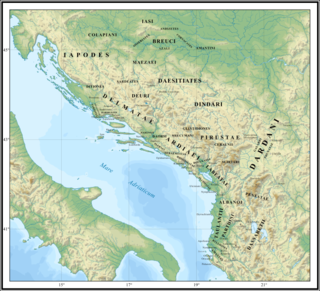
In classical and late antiquity, Illyria was a region in the western part of the Balkan Peninsula inhabited by numerous tribes of people collectively known as the Illyrians.

Vlorë is the third most populous city of the Republic of Albania and seat of Vlorë County and Vlorë Municipality. Located in southwestern Albania, Vlorë sprawls on the Bay of Vlorë and is surrounded by the foothills of the Ceraunian Mountains along the Albanian Adriatic and Ionian Sea Coasts. It experiences a Mediterranean climate, which is affected by the Ceraunian Mountains and the proximity to the Mediterranean Sea.

Apollonia was an Ancient Greek trade colony which developed into an independent polis, and later a Roman city, in southern Illyria. It was located on the right bank of the Aoös/Vjosë river, approximately 10 km from the eastern coast of the Adriatic Sea. Its ruins are situated in the county of Fier, close to the village of Pojan, in Albania.

The Vjosa or Aoös is a river in northwestern Greece and southwestern Albania. Its total length is about 272 kilometres (169 mi), of which the first 80 kilometres (50 mi) are in Greece, and the remaining 192 kilometres (119 mi) in Albania. Its drainage basin is 6,706 km2 (2,589 sq mi) and its average discharge is 195 m3/s (6,900 cu ft/s). The main tributaries are Voidomatis, Sarantaporos, Drino and Shushicë.

Amantia was an ancient city and the main settlement of the Amantes, traditionally located in southern Illyria in classical antiquity. In Hellenistic times the city was either part of Illyria or Epirus. In Roman times it was included within Epirus Nova, in the province of Macedonia. The site has been identified with the village of Ploçë, Vlorë County, Albania. Amantia was designated as an archaeological park on 7 April 2003 by the government of Albania.
The Parthini, Partini or Partheni were an Illyrian tribe that lived in the inlands of southern Illyria. They likely were located in the Shkumbin valley controlling the important route between the Adriatic Sea and Macedonia, which corresponded to the Via Egnatia of Roman times. Consequently, their neighbours to the west were the Taulantii and to the east the Dassaretii in the region of Lychnidus.
Thronion was an Ancient Greek city on the Illyrian coast, in the Bay of Vlorë on the southern Adriatic Sea. Although the earliest contacts appear to have been more pre-colonial activity rather than permanent settlement, an ancient, still archaeologically unproven tradition claims that the city was founded as a Locrian–Euboean colony on the fringes of the territory of the Amantes. Thronion was located to the south of the territory of Apollonia and in front of the Acroceraunian Mountains, the natural boundary between ancient Epirus and Illyria. Thronion was conquered by nearby Apollonia before 460 BCE.

Oricum was a harbor on the Illyrian coast that developed in an Ancient Greek polis at the south end of the Bay of Vlorë on the southern Adriatic coast. It was located at the foot of the Akrokeraunian Mountains, the natural border between ancient Epirus and Illyria. Oricum later became an important Roman city between the provinces of Epirus Vetus and Epirus Nova in Macedonia. It is now an archaeological park of Albania, near modern Orikum, Vlorë County. Oricum holds such a strategic geographical position that the area has been in continuous usage as a naval base from antiquity to the present-days.
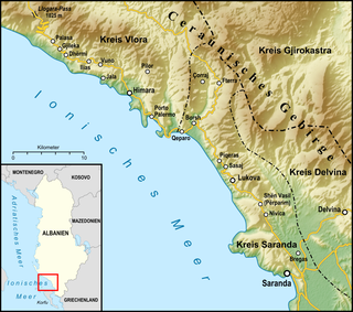
The Albanian Riviera, also popularly known as Bregu, is a coastline along the north-eastern Ionian Sea in the Mediterranean Sea, encompassing the districts of Sarandë and Vlorë in south-western Albania. It forms an important section of the Albanian Ionian Sea Coast, dotted with the villages of Palasë, Dhërmi, Vuno, Himara, Qeparo, Borsh, Piqeras, Lukovë, and the city of Sarandë.
Olympe was an ancient city located in the territory of the Amantes, between northern Epirus and southern Illyria in classical antiquity. It is located in modern day Mavrovë, Vlorë County, Albania.

The Ceraunian Mountains are a coastal mountain range in southwestern Albania, within the Vlorë County.
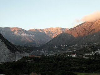
Dukat is a community in Vlorë County, southern Albania. With the 2015 local government reform, it became part of the municipality Vlorë. The Dukat Plain covers an area of around 1,000–1,500 ha delimited by the Ceraunian Mountains and opened in the north towards the Bay of Vlorë on the Adriatic. Dukat traditionally belongs to the Albanian ethnographic region of Labëria.

The Bay of Vlorë is a large bay of the Adriatic Sea situated along the Albanian Adriatic Sea Coast on the Mediterranean Sea in Southern Europe. It opens to the sea in the northwest and is largely surrounded by the lagoon of Narta in the north, the city of Vlorë in the northeast, the mountains of the Ceraunians in the east and southeast, and the peninsula of Karaburun in the southwest and west.

Palasë also Paljasa, is a village in Himarë municipality, Vlorë County, southern Albania. It is located near the Llogara National Park and next to the Ionian coast on the Albanian Riviera. The village is inhabited by ethnic Greeks who speak the unique Himariote Greek dialect.
Bardylis II was an Illyrian king, and presumably the son of Cleitus, and grandson of Bardylis. He was the father of Bircenna, wife of Pyrrhus of Epirus. Bardylis II is the only attested Illyrian king after Glaucias' death. He may have succeeded Glaucias on the throne as the grandson of Bardylis I, or alternatively he may have reigned independently after his father Cleitus somewhere in Dassaretia, in an area located nearer the Macedonian border. At that time Bardylis II was evidently the most powerful king in Illyria who could unite the largest number of Illyrian tribes under his rule.
The Amantes were an ancient tribe located in the inland area of the Bay of Vlora north of the Ceraunian Mountains and south of Apollonia, in southern Illyria near the boundary with Epirus, nowadays modern Albania. A site of their location has been identified with the archaeological settlement of Amantia, placed above the river Vjosë/Aoos. Amantia is considered to have been their main settlement. The Amantes also inhabited in the area of an ancient sanctuary of the eternal fire called Nymphaion.
The Balaites were an ancient tribe in southern Illyria, modern-day Albania. The tribe is known from a number of Greek inscriptions, otherwise unmentioned among ancient written sources.
Illyrology or Illyrian studies is interdisciplinary academic field which focuses on scientific study of Illyria and Illyrians as a regional and thematic branch of the larger disciplines of ancient history and archaeology. A practitioner of the discipline is called Illyrologist. His duty is to investigate the range of ancient Illyrian history, culture, art, language, heraldry, numizmatic, mythology, economics, ethics, etc. from c. 1000 BC up to the end of Roman rule around the 5th century.

Triport or Treport is a cape and historic harbor on the Adriatic Sea northwest of Vlorë, Albania. It is located in Vlorë municipality, and constitutes the northern limit of the Bay of Vlorë. Located 5 km northwest of the city, the harbor of Triport is the Fishing Port of Vlorë. It is one of the most important fishing ports of Albania, featuring the country's second largest fishing fleet.
