This page is based on this
Wikipedia article Text is available under the
CC BY-SA 4.0 license; additional terms may apply.
Images, videos and audio are available under their respective licenses.

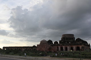
Kalpi is a town and a municipal board in Jalaun district in the Indian state of Uttar Pradesh. It is on the right bank of the Yamuna. It is situated 78 kilometre south-west of Kanpur from which it is connected by both road and rail.

Jalaun district is a district of Uttar Pradesh state of India.

Dibiyapur is in Auraiya district in the most populous state of Uttar Pradesh in India.
It is situated on State Highway 21.
It is linked to Phaphund railway station on Kanpur-Delhi section of Howrah-Delhi main line which is operated by North Central Railway.
The district administrative headquarter of the town is Auraiya.

Pukhrayan is a town and a Municipality in Kanpur Dehat district in the Indian state of Uttar Pradesh. Found to the south-west of Mati on National Highway 25, Pukhrayan is 4 km from Bhognipur.

Rura is an adarsh town and a Nagar Panchayat in Kanpur Dehat District in Uttar Pradesh state of the India. The town is situated on the banks of Lower Ganga canal. It is a major town in the Kanpur Dehat. Bhatauli is adjacent to Rura city which is known as Bhatauli-Rura town.The nearby cities are Kanpur (44 km) towards the east and Etawah (96 km) towards the west. The district headquarters is nearly 15 km away at Akbarpur-Mati. It comes under Kanpur Metropolitan Area.

Shivli or Sheoli is a town and a nagar panchayat in Kanpur Dehat district in the Indian state of Uttar Pradesh. It is located at 26°37′0″N 80°3′0″E and has an average elevation of 128 meters (423 feet).

Sirathu is a town and Nagar Panchayat in Kaushambi district in the Indian state of Uttar Pradesh. It is one of oldest town in Kaushambi district. The town has a population of approximately 2700.

Kanpur Central or Cawnpore North Barracks(CNB) is a railway station located in the city of Kanpur and is one of the five central Indian railway stations. It is the busiest Indian Railways station in terms of passengers, recording more than 2.3 million passengers per day, and is the second-busiest railway station in India in terms of frequency of trains, with around 611 trains passing through daily. The station is a major intercity rail and commuter rail station in the region. More than 1580 stations are directly connected to it, the highest number of connections to a single station in the country. As so, it is amongst the most profitable railway station in India.
Rajpur is a village in Kanpur Dehat district in the state of Uttar Pradesh, with having all facilities like schools, hospital,Market for a normal Indian Lifestyle. approximately 17 km west of Bhognipur& 12 km east of Sikandra On NH 2A. It is a development block of [Sikandra] tehsil.The nearest Railway Station is Pukhrayan with a distance of approx 20 km & Airport is CCIA Amausi Lucknow distance 160 km approx.

Ghatampur (Gautampur) is a city and a municipal board in Kanpur Nagar district in the state of Uttar Pradesh, India.

Bhaupur is a town in Kanpur Dehat district in the state of Uttar Pradesh, India.World Bank Funding Develop Bhaupur Industrial Sector UPSIDC Ludhiyana Kolkata Dedicated Coridore

Rasulpur Gogumau is a town in Kanpur Dehat district in the state of Uttar Pradesh, India.

Paman is a village in Kanpur Dehat district in the state of Uttar Pradesh, India.
Tilaunchi is a village in Kanpur Dehat district in the state of Uttar Pradesh, India.

Lalpur is a village in Kanpur Dehat district in the state of Uttar Pradesh, India.

Chaunrah is a village in Kanpur Dehat district in the state of Uttar Pradesh, India.

Ambiyapur is a village in Kanpur Dehat district in the state of Uttar Pradesh, India.

Binaur is a town in Kanpur district in the state of Uttar Pradesh, India.

Injuwarampur is a village in Kanpur Dehat district in the state of Uttar Pradesh, India.

Ait railway station is a small railway station located in Jalaun, Konch in the Indian state of Uttar Pradesh. Nearby major railway station is Jhansi Jn and the airport is Gwalior Airport. It belongs to North Central, Jhansi Jn.


