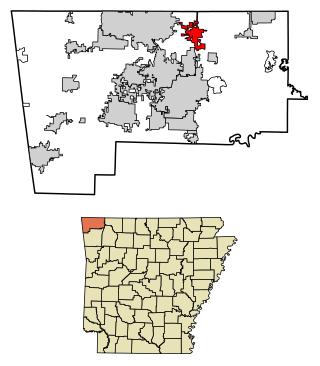
Pea Ridge is a city in Benton County, Arkansas, United States. The name Pea Ridge is derived from a combination of the physical location of the original settlement of the town, across the crest of a ridge of the Ozark Mountains, and for the hog peanuts or turkey peas that had been originally cultivated by Native American tribes centuries before European settlement, which later helped to provide basic subsistence once those pioneer settlers arrived.
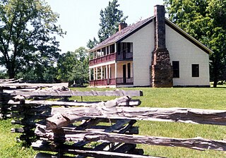
Pea Ridge National Military Park is a United States National Military Park located in northwest Arkansas near the Missouri border. The park protects the site of the Battle of Pea Ridge, fought March 7 and 8, 1862. The battle was a victory for the Union and helped it gain control of the crucial border state of Missouri.

Elkhorn Tavern is a two-story, wood-frame structure that served as a physical center for the American Civil War Battle of Pea Ridge, also known as the Battle of Elkhorn Tavern, which was fought on March 7 and March 8, 1862, approximately five miles east of Pea Ridge, Arkansas, located in the northeastern Benton County, Arkansas. The tavern, a replica built in 1865 following the burning of the original building by bushwhackers, is now the centerpiece of the Pea Ridge National Military Park, which includes approximately 5,000 acres (2,000 ha) around the structure, including the restored battlefields, a stretch of the pre-war Telegraph Road, which runs directly in front of the tavern, and a section of the Trail of Tears. The tavern is on the National Register of Historic Places.

Hillcrest Historic District is a historic neighborhood in Little Rock, Arkansas that was listed on the National Register of Historic Places on December 18, 1990. It is often referred to as Hillcrest by the people who live there, although the district's boundaries actually encompass several neighborhood additions that were once part of the incorporated town of Pulaski Heights. The town of Pulaski Heights was annexed to the city of Little Rock in 1916. The Hillcrest Residents Association uses the tagline "Heart of Little Rock" because the area is located almost directly in the center of the city and was the first street car suburb in Little Rock and among the first of neighborhoods in Arkansas.
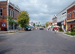
The Rogers Commercial Historic District, known informally as Historic Downtown Rogers, is a historic district in the central business district of Rogers, Arkansas. When it was first listed on the National Register of Historic Places in 1988, it was known as the Walnut Street Historic District; this was changed when the district was enlarged in 1993. The district encompasses a portion of the city's central business district, whose historical significance extends from about 1885 to the end of World War II.

Twelve special routes of U.S. Route 63 currently exist. Arkansas and Missouri each contain five, with two in Iowa. There are also five former routings that have been removed from the system.
Stroud's Mercantile or Stroud's Department Store was a department store located in Rogers, Arkansas. At the time of its closing in 1993, Stroud's was the oldest continuously operated privately owned retail business in the state. Its 1899 storefront at 114-116 West Walnut is a contributing property to the Rogers Commercial Historic District on the National Register of Historic Places. Two homes owned by Stroud family members; the Stroud House originally in Rogers, but later moved to Pea Ridge, Arkansas, and the Stroud House in Bentonville, Arkansas are individually listed.

The Cherry Street Historic District is a historic neighborhood, commercial, and entertainment district serving as the downtown of Helena in Helena–West Helena, Arkansas. Cherry Street is located between Elm Street and the nearby Phillips County Courthouse to the north, and Porter Street to the south. The history of Cherry Street is tied to the blues heritage of the area beginning in the 1940s.

Mount Nord Historic District is a historic district in Fayetteville, Arkansas encompassing one city block with five properties. The district lies atop a rise of about 140 feet (43 m) above the surrounding area. The properties were built between 1901 and 1925 in various architectural styles, and the area was listed on the National Register of Historic Places in 1982.

The Van Buren Historic District encompasses eight blocks of historic buildings along Main Street in Van Buren, Arkansas. Many of the structures are pre-1920 Victorian and Italianate buildings closely related to the history of commerce in the city. Positioned between the city's train depot and the Arkansas River, the businesses constituting the Van Buren Historic District have played a vital role in the history and economy of the city and region. The district was placed on the National Register of Historic Places as a National Historic District on April 30, 1976.
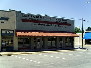
The Star City Commercial Historic District encompasses the historic commercial center of Star City, Arkansas, the county seat of Lincoln County. The district consists of thirteen buildings on two city blocks, as well as the Star City Confederate Memorial. The buildings are located on Jefferson Street, between Arkansas and Bradley Streets, and on Bradley Street between Jefferson and Drew Streets. The memorial is located in the town square, near the junction of Jefferson and Bradley. The buildings in the district were built between 1916 and 1928, and have for the most part escaped major alterations since their construction. Minor changes generally involve changes to store fronts, such as the boarding over of transom windows, the replacement of recessed entries with flush ones, and changes to the fenestration. The building at 108 Jefferson, built in 1927 to house a bar, has been extensively remodeled and does not contribute to the district's significance; the Star Theater building at 212-214 Bradley has also been extensively altered.

The Stuttgart Commercial Historic District encompasses a portion of the commercial center of Stuttgart, Arkansas. The district extends along Main Street between 1st and 6th Streets, and includes a few buildings on the adjacent numbered streets as well as Maple and College Streets, which parallel Main to the west and east, respectively. The majority of the district's 76 buildings were built between about 1900 and 1920, and are brick commercial structures one or two stories in height. Notable among these buildings are the Riceland Hotel, the Standard Ice Company Building, and the county courthouse.

The Blytheville Commercial Historic District encompasses most of the central business district of Blytheville, Arkansas, one of the TWO JUDICIAL DISTRICTS of Mississippi County. It extends along Main Street between 5th and Franklin Streets, and along Ash Street between 5th and 2nd. Most of the 39 buildings in the district were built between 1890 and 1956, in three phases of development. The two oldest buildings in the district, both dating to c. 1890, are at 112 West Main and 106 East Main. The building traditionally viewed as the anchor of the downtown area is the Kirby-Heath building at the corner of Main and 2nd, built 1901.

The Walnut Ridge Commercial Historic District encompasses the historic town center of Walnut Ridge, Arkansas, the county seat of Lawrence County. The district includes a four-block stretch of Main Street on the northwest side of the railroad tracks, and extends for one and sometimes two blocks on either side. Walnut Ridge was founded as a railroad town in 1875, and soon became a leading economic center in the county. Most of its historic downtown consists of vernacular commercial architecture dating to the late 19th and early 20th centuries, built of masonry and brick, and one or two stories in height. Notable buildings include the 1924 Swan Theatre at 222 West Main Street, the 1935 Old Walnut Ridge Post Office at 225 West Main, and the 1965 Lawrence County Courthouse at 315 West Main, which replaced a c. 1900 structure.

The Hardy Downtown Historic District encompasses most of the central business district of the resort community of Hardy, Arkansas. It extends along Main Street, between Church and Cope Streets, and includes a few buildings on adjacent streets. Hardy was founded as a railroad town in the 1880s, but grew by the end of the 19th century into a resort community, serving as commercial center for vacationers from Memphis, Tennessee. Most of the 43 buildings in the district are between one and three stories in height, and of masonry construction. Twenty-four are historically significant, and many of the remaining buildings date to the early 20th century but have been altered in unsympathetic ways. Notable buildings include the Hardy Church of Christ, and the Raymond Daugherty House, one of the community's oldest buildings.
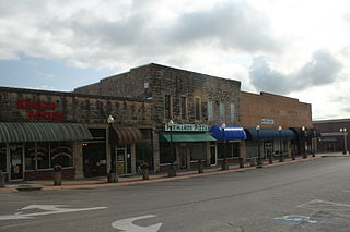
The Mountain Home Commercial Historic District encompasses the historic central business district of Mountain Home, Arkansas, the county seat of Baxter County. The district is centered on the Baxter County Courthouse, and is bounded on the north by East 5th Street, the south by East 9th Street, the east by South Street, and the west by South Hickory Street. Most of the buildings in this area are commercial structures, one or two stories in height, of masonry construction. They are generally vernacular in style, and most were built in one of two periods: between about 1900 and 1920, after the arrival of the railroad, and in the 1950s, when the city experienced another major period of growth. The oldest building is the 1892 Baker Building at 601-603 Baker Street.

The Pine Bluff Commercial Historic District encompasses a portion of the historic city center of Pine Bluff, Arkansas. It extends from Barraque Street south along Main Street, extending in places to properties alongside streets. The area's commercial development began about 1840, when the courthouse square was laid out at Barraque and Main, and proceeded through the early 20th century. Most of the commercial properties of the district were built between 1880 and 1910, and are reflective architecturally of late 19th-century commercial building styles.
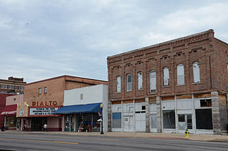
The Morrilton Commercial Historic District encompasses the historic central business district of Morrilton, Arkansas. The L-shaped district includes two blocks of East Railroad and East Broadway, between Division and Chestnut Streets, and three blocks of Division and Chestnut Streets, between Broadway and Vine. This area was mostly developed between 1880 and the 1920s, and was heavily influenced by the railroad, which passes between Broadway and Railroad. Prominent buildings in the district include the Morrilton Post Office, Morrilton Railroad Station, First National Bank of Morrilton, and the Coca-Cola Building.

The Atkins Commercial Historic District encompasses the historic business district of Atkins, Arkansas. It extends for two blocks on Main Street and 1st Street, between Church and 2nd Avenues. This area was largely developed between 1890 and 1959 as a trade and manufacturing center for the surrounding area, with most of its architecture dating before 1921. Most of the buildings are brick single-story buildings with vernacular commercial designs.


