
Bass Strait is a strait separating the island state of Tasmania from the Australian mainland. The strait provides the most direct waterway between the Great Australian Bight and the Tasman Sea, and is also the only maritime route into the economically prominent Port Phillip Bay.

French Island is the largest coastal island of Victoria, Australia, located in Western Port, 61 km (38 mi) southeast of Melbourne. In 1997, about 70% of the island was declared the French Island National Park, administered by Parks Victoria, and was listed in the former Register of the National Estate in 1984. The island is an unincorporated area under the direct administration of the government of Victoria, and is a declared locality of Victoria having its own postcode. Community issues are dealt by the French Island Community Association. The island is otherwise administered by the Department of Transport (Victoria). The population of the island in 2011 was around 116 people, of which about 60 were permanent residents. By 2021 the population on census night was recorded as 139 with a median age of 52 years.

Phillip Island is an Australian island about 125 km (78 mi) south-southeast of Melbourne, Victoria. The island is named after Governor Arthur Phillip, the first Governor of New South Wales, by explorer and seaman George Bass, who sailed in an whaleboat, arriving from Sydney on 5 January 1798.

Flinders Island, the largest island in the Furneaux Group, is a 1,367-square-kilometre (528 sq mi) island in the Bass Strait, northeast of the island of Tasmania. Today Flinders Island is part of the state of Tasmania, Australia. It is 54 kilometres (34 mi) from Cape Portland and is located on 40° south, a zone known as the Roaring Forties.
Western Port, commonly but unofficially known as Western Port Bay, is a large tidal bay in southern Victoria, Australia, opening into Bass Strait. It is the second largest bay in the state. Geographically, it is dominated by two large islands; French Island and Phillip Island. At the time it was renamed, its position was west of other known ports and bays, but Western Port has become something of a misnomer as it lies just to the east of the larger Port Phillip and the city of Melbourne. It is visited by Australian fur seals, whales and dolphins, as well as many migratory waders and seabirds. It is listed under the Ramsar Convention as a wetland of international significance.
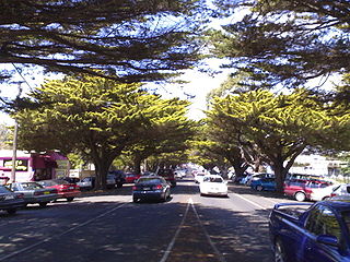
Cowes is the main township on Phillip Island in the Gippsland region of Victoria, Australia. It is about two hours' drive from Melbourne and can also be reached by coach, or passenger ferry from Stony Point on the Mornington Peninsula. Cowes is located on the northern side of Phillip Island and faces towards French Island and the Mornington Peninsula. At the 2021 census, Cowes had a population of 6,593.
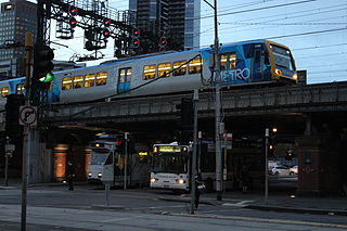
Transport in Melbourne, the state capital of Victoria, Australia, consists of several interlinking modes. Melbourne is a hub for intercity, intracity and regional travel. Road-based transport accounts for most trips across many parts of the city, facilitated by Australia's largest freeway network. Public transport, including the world's largest tram network, trains and buses, also forms a key part of the transport system. Other dominant modes include walking, cycling and commercial-passenger vehicle services such as taxis.

Victoria is a state in southeastern Australia. It is the second-smallest state, with a land area of 227,444 km2 (87,817 sq mi); the second-most-populated state, with a population of over 6.6 million; and the most densely populated state in Australia. Victoria is bordered by New South Wales to the north and South Australia to the west, and is bounded by the Bass Strait to the south, the Great Australian Bight portion of the Southern Ocean to the southwest, and the Tasman Sea to the southeast. The state encompasses a range of climates and geographical features from its temperate coastal and central regions to the Victorian Alps in the northeast and the semi-arid north-west.
King Island Airport is a small regional airport located near the town of Currie on King Island off the north-west coast of Tasmania, Australia. The airport is owned and operated by the King Island Council.

Duck Island, a small barrier island, lies 1.5 km north of Swan Island and south of Edwards Point in the main entrance to Swan Bay from Port Phillip in southern Victoria, Australia. It is part of the Port Phillip Heads Marine National Park and the plants and animals on and around the island are protected, including the critically endangered orange-bellied parrot. The island is part of the Swan Bay and Port Phillip Bay Islands Important Bird Area, identified as such by BirdLife International.

Pope's Eye is the uncompleted foundation for an island fort intended to defend the entrance to Port Phillip in the state of Victoria, Australia. The undefined area of the fort, generally assessed at 4 hectares, is one of six separate areas that comprise the Port Phillip Heads Marine National Park and is a popular site for divers.
The Port Phillip Heads Marine National Park is a marine protected area located in the vicinity of the bay of Port Phillip, between the Bellarine and Mornington Peninsulas, in Victoria, Australia. The 3,580-hectare (8,800-acre) marine national park comprises six separate sites located approximately 60 kilometres (37 mi) south-west of Melbourne and stretches along 40 kilometres (25 mi) of coastline of Victoria.

South Channel Fort, also known as South Channel Island, is a 0.7 ha artificial island in southern Port Phillip, Victoria, Australia, 6 km north-east of the town of Sorrento. It was part of a network of fortifications protecting the narrow entrance to Port Phillip.
Phillip Island Road is a tourist highway in Victoria, Australia and branches off the Bass Highway at the township of Anderson. Previously assigned State Route 186, it was later designated B420. It was named due to the Phillip Island Bridge which opened in San Remo on the 21 November 1969.

The Shire of Phillip Island was a local government area in Western Port Bay, about 120 kilometres (75 mi) south of Melbourne, the state capital of Victoria, Australia. The shire covered an area of 101.05 square kilometres (39.0 sq mi), and existed from 1928 until 1994.
Matakana Nominees Pty. Ltd., trading as King Island Airlines, is a small regional airline based in Moorabbin, Australia. It operates a service between Moorabbin in Victoria and King Island.

Churchill Island is a 50.7-hectare (125.3-acre) island in Western Port, Victoria, Australia. It is connected by a bridge to Phillip Island, which is in turn connected to the mainland by another bridge. It is the site of the first European garden in Victoria. It contains a working farm, cottages dating from the 1860s and a homestead dating from 1872, all fully restored and open to the public. The island adjoins the 670-hectare (1,656-acre) Churchill Island Marine National Park. The island is maintained by Phillip Island Nature Parks.
The National Vietnam Veterans Museum is an Australian war museum located in Phillip Island, Victoria. Originally it was established in San Remo, Victoria in 1996 by Vietnam veteran John Methven. In March 2007 it moved to a larger site near the Phillip Island Airport. The museum contains a large collection of items and vehicles, including a Centurion tank, a Mark V International Harvester truck and a 105mm pack howitzer. It also has a collection of aircraft from the era of the Vietnam war, including a de Havilland Canada DHC-4 Caribou transport plane, an English Electric Canberra bomber, a Westland Wessex helicopter, a Bell AH-1 Cobra helicopter gunship, Bell UH-1 Iroquois helicopter, a Bell H-13 Sioux helicopter and a Grumman S-2 Tracker anti-submarine warfare aircraft.
Ventnor is a small town on Phillip Island in Victoria, Australia. It is the location of the Phillip Island Grand Prix Circuit.
