
West Warwick is a town in Kent County, Rhode Island, United States. The population was 31,012 at the 2020 census.
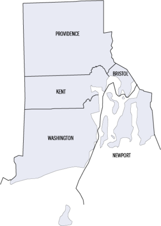
This is a list of properties and districts listed on the National Register of Historic Places in Rhode Island. As of May 29, 2015, there are more than 750 listed sites in Rhode Island. All 5 of the counties in Rhode Island have listings on the National Register.

The Blackstone Canal was a manmade waterway, linking Worcester, Massachusetts, to Providence, Rhode Island, and Narragansett Bay, through the Blackstone Valley, via a series of locks and canals in the early 19th century. Construction started in 1825, and the canal opened three years later. After the opening of the Boston and Providence Railroad (1835), the canal struggled for business. Its transportation role was taken over by the Providence and Worcester Railroad, which completed a parallel line in 1847. The canal shut down in 1848. Several segments of the canal are preserved, and the canal alignment and remains are on the National Register of Historic Places.

Roger Williams Park is an elaborately landscaped 427-acre (173 ha) city park in Providence, Rhode Island and a historic district listed on the National Register of Historic Places. The park is named after Roger Williams, the founder of the city of Providence and the primary founder of the state of Rhode Island.

The Ten Mile River is a river within the U.S. states of Massachusetts and Rhode Island. It flows approximately 22 miles (35 km) and drains a watershed of 54 square miles (140 km2).

Slatersville is a village on the Branch River in the town of North Smithfield, Rhode Island, United States. It includes the Slatersville Historic District, a historic district listed on the National Register of Historic Places. The historic district has been included as part of the Blackstone River Valley National Historical Park. The North Smithfield Public Library is located in Slatersville.
Georgiaville is a village in Smithfield, Providence County, Rhode Island, United States. The village was named after the Georgia Cotton Manufacturing Company mill located in the area. The Georgiaville Pond Beach is located in the village and is a popular recreation spot. In the 1920s the Ku Klux Klan was active in the area, and Klan rallies were held in Georgiaville. The village, which has retained many features of its origin as a mid-19th century mill village, including the mill complex and several blocks of mill worker housing, was added to the National Register of Historic Places in 1985. Georgiaville is also where Smithfield's town hall is located.

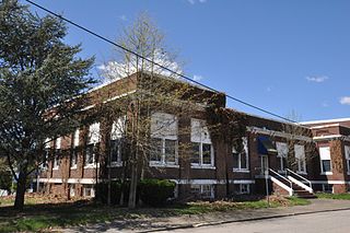
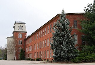
This is a list of the National Register of Historic Places listings in Providence County, Rhode Island.

Saylesville is a village and historic district in Lincoln, Rhode Island, United States.
Clayville Historic District is an 81-acre (33 ha) historic district in Foster and Scituate, Rhode Island. The district encompasses the heart of the village of Clayville, a small 19th-century mill village. It is centered on the junction of Plainfield Pike, Field Hill Road, and Victory Highway near the Clayville Mill pond, and is roughly bisected by the town line between Foster and Scituate. The mill pond is impounded by a c. 1847 dam, which powered mills whose ruins and waterways lie downstream. The village is mainly residential, with vernacular 19th-century construction predominating. Notable buildings include the Clayville Christian Union Church, built 1867–71 with Greek Revival styling, and the c. 1845 Clayville Schoolhouse.

See also Daggett House, Slater Park, Pawtucket RI, built about the same time, by Nathaniel's father John.

The Greystone Mill Historic District encompasses an early 20th-century textile mill complex on Greystone Avenue in Johnston and North Providence, Rhode Island. The complex consists of three brick buildings on the North Providence side of the Woonasquatucket River, a dam spanning the river, and a water tank near the dam in Johnston. The main structure consists of a series of structures combined to form a rambling structure, built between 1904 and 1911 to designs by Frank Sheldon and Son, an architectural firm that was a leading designer of textile facilities at the time.

The Norwood Avenue Historic District is a residential historic district in Cranston and Providence, Rhode Island. It includes all the properties along Norwood Avenue between Broad Street in Cranston and Green Boulevard in Providence. It is lined with houses built mostly between 1890 and 1930 in the Queen Anne and Colonial Revival styles.
The Rumford Chemical Works and Mill House Historic District is a historic district encompassing the remnants of the Rumford Chemical Works, a historical chemical plant in East Providence, Rhode Island, founded by Eben Horsford and George F. Wilson.
The Richmond Paper Company Mill Complex is an historic American paper mill at 310 Bourne Avenue in East Providence, Rhode Island. It comprises a group of mainly brick buildings on 13 acres (5.3 ha) of land, bounded on the north by Bourne Avenue, the east by railroad tracks, the west by the Seekonk River, and on the south by land formerly owned by the Washburn Wire Company. The first seven of the surviving buildings were built between 1883 and 1887 by the Richmond Paper Company. The property was acquired at auction in 1894 by Eugene Phillips, who operated the American Electrical Works on the premises, adding more buildings between 1900 and 1930 and demolishing several buildings specific to paper processing. The modern property has a variety of light industrial uses. The Richmond Paper Company was the place where Arthur Dehon Little began his career.

The Dyerville Mill is an historic textile mill complex at 610 Manton Avenue in Providence, Rhode Island, USA. Its oldest buildings dating to 1835, it is one of the oldest textile mills in the city. The complex is located between Manton Avenue and the Woonasquatucket River, just south of the Dyerville Mill Pond. Remnants of the head race run south from the pond, through the property, with the tail race exiting to the southwest. The main mill building is a 3+1⁄2-story L-shaped stuccoed stone structure. The picker house is a 2+1⁄2-story stone structure southwest of the main mill, with a brick extension that also gives it an L shape and creates a courtyard with the main building. A 20th-century warehouse stands south of this complex. The mill was established by Elisha Dyer, father of Elisha Dyer and grandfather of Elisha Dyer, Jr., and was operated by the Dyer family until 1867. It was then operated by cotton broker Truman Beckwith and his son. The Joslin Manufacturing Company purchased the business in 1903 and operated textile production on the site until the 1930s. The site has thereafter seen other light industrial uses.

The Wanskuck Historic District is a historic district in the city of Providence, Rhode Island encompassing a mill village with more than two hundred years of history. As early as the mid-18th century, mills stood on the West River in northern Providence, a development which continued with the rise of industrialization in the 19th century. The mill village of Wanskuck is organized around three thoroughfares: Branch Street, Veazie Street, and Woodward Road, and is roughly bounded on the east by Louisquisset Pike and to the northwest by the city line with North Providence. The West River runs through the district, with its banks lined by two late-19th-century mill complexes. The village area includes a variety of examples of mill worker housing, from duplexes to rowhouses, as well as two church complexes and a community hall built in 1884 by the Wanskuck Company.
Lafayette Village is a historic district extending along Ten Rod Road in North Kingstown, Rhode Island. It encompasses a linear rural and industrial village, running from the Wickford Junction railroad crossing in the west to Angel Avenue in the east, and includes a number of residential properties on adjacent side streets. The centerpiece of the district is the Rodman Manufacturing Company complex, which operated here for a century beginning in the 1840s. The Robert Rodman Mansion, a Second Empire house with an elaborate porch, stands at 731 Ten Rod Road, and the Walter Rodman House, built in the 1870s, is even more elaborately decorated. Most of the residential stock in the district is mill-related housing built by the Rodmans for their workers.

The Greystone Historic District is a historic district encompassing the early 20th-century mill village of Greystone in North Providence, Rhode Island. The district most significant elements is the Greystone Mill, a complex of brick industrial buildings on the North Providence side of the Woonasquatucket River, as well as the dam spanning the river and a water tank in Johnston. The village, entirely in North Providence, was developed between 1904 and 1912 by Joseph Benn and Company, the mill proprietors, to provide housing for its workers. The main focus of the village is on junction of Greystone Road and Oakleigh Avenue. The company built a variety of housing types, including duplexes and tenements, which line some of the side streets. There are four houses, dating as far back as 1822, that predate the primary industrial activity here. The most prominent feature of the village is the Greystone (Primitive) Methodist Church on Oakleigh Avenue.

The Omega Pond Railroad Bridge is a railroad bridge spanning the western end of Omega Pond in East Providence, Rhode Island. The bridge is a contributing structure to the Phillipsdale Historic District listed on the National Register of Historic Places.


