Philmont, New York

Last updated
Philmont, New York
Downtown Philmont, NY.jpg
Downtown Philmont, looking east along NY 217
Columbia County New York incorporated areas Village of Philmont highlighted.svg
Location of Philmont, New York
New York in United States (US48).svg
Location of New York in the United States
Coordinates: 42°14′56″N73°38′56″W / 42.24889°N 73.64889°W / 42.24889; -73.64889 Coordinates: 42°14′56″N73°38′56″W / 42.24889°N 73.64889°W / 42.24889; -73.64889
CountryUnited States
State New York
County Columbia
Founded1892
Government
  MayorBrian Johnson
Area
[1]
  Total1.25 sq mi (3.25 km2)
  Land1.22 sq mi (3.15 km2)
  Water0.04 sq mi (0.10 km2)
Elevation
500 ft (200 m)
Highest elevation
(Unnamed hill in SE quadrant of village)
690 ft (210 m)
Lowest elevation
(Agawamuck Creek on W boundary)
280 ft (90 m)
Population
 (2020)
  Total1,377
  Density1,132.40/sq mi (437.39/km2)
Time zone UTC-5 (Eastern (EST))
  Summer (DST) UTC-4 (EDT)
ZIP Code
12565
Area code 518
FIPS code 36-57639
GNIS feature ID0960311
Website www.philmont.org

Philmont is a village in Columbia County, New York, United States. The population was 1,379 at the 2010 census. [2] The village is located in the northeastern part of the town of Claverack on New York State Route 217.

Contents

History

The community was once known as "Factory Hill" due to the number of wool factories. The village was incorporated in 1891. It derives its name from George P. Philip, who built a 36-acre (15 ha) reservoir to provide water for his mill. This in turn led to construction of a 56-acre (23 ha) reservoir up the "mountain" in the Taconic Mountains to guarantee water to the mills, thus creating the factory hill. [3]

Geography

Philmont is located at 42°14′55″N73°38′51″W / 42.24861°N 73.64750°W / 42.24861; -73.64750 (42.248620, -73.647602). [4]

According to the United States Census Bureau, the village has a total area of 1.23 square miles (3.18 km2), of which 1.19 square miles (3.08 km2) is land and 0.04 square miles (0.10 km2), or 3.16%, is water. [2]

The village is along Agawamuck Creek, which drops over its High Falls near the center of the village. The creek is a tributary of Claverack Creek, which flows about 7.5 miles (12.1 km) to the Hudson River.

Demographics

Historical population
CensusPop.
1880 1,343
1890 1,81835.4%
1900 1,9648.0%
1910 1,813−7.7%
1920 1,9195.8%
1930 1,868−2.7%
1940 1,679−10.1%
1950 1,7926.7%
1960 1,750−2.3%
1970 1,674−4.3%
1980 1,539−8.1%
1990 1,6235.5%
2000 1,480−8.8%
2010 1,379−6.8%
2020 1,377−0.1%
U.S. Decennial Census [5]

As of the census [6] of 2000, there were 1,480 people, 576 households, and 361 families residing in the village. The population density was 1,256.9 people per square mile (484.3/km2). There were 644 housing units at an average density of 546.9 per square mile (210.7/km2). The racial makeup of the village was 94.53% White, 1.69% African American, 0.34% Native American, 0.20% Asian, 1.96% from other races, and 1.28% from two or more races. Hispanic or Latino of any race were 3.72% of the population.

There were 576 households, out of which 34.2% had children under the age of 18 living with them, 45.0% were married couples living together, 11.6% had a female householder with no husband present, and 37.3% were non-families. 29.5% of all households were made up of individuals, and 13.7% had someone living alone who was 65 years of age or older. The average household size was 2.55 and the average family size was 3.20.

In the village, the population was spread out, with 28.9% under the age of 18, 8.0% from 18 to 24, 29.4% from 25 to 44, 19.9% from 45 to 64, and 13.8% who were 65 years of age or older. The median age was 35 years. For every 100 females, there were 98.4 males. For every 100 females age 18 and over, there were 94.5 males.

The median income for a household in the village was $31,094, and the median income for a family was $41,944. Males had a median income of $27,188 versus $23,274 for females. The per capita income for the village was $16,162. About 11.3% of families and 13.7% of the population were below the poverty line, including 14.9% of those under age 18 and 6.3% of those age 65 or over.

Sites of interest

High Falls in the winter of 2013 High Falls Philmont, NY winter.jpg
High Falls in the winter of 2013

The High Falls Conservation Area, a 47-acre (19 ha) property in the village, with access from the town of Claverack, is owned and managed by the Columbia Land Conservancy. High Falls, Columbia County's highest waterfall, cascades 150 feet (46 m) before culminating in a large pool. The water flows southwest, then northwest by Claverack Creek, until eventually reaching the Hudson River.

The village is part of the Taconic Hills Central School District.

Notable people

Related Research Articles

<span class="mw-page-title-main">Columbia County, New York</span> County in New York, United States

Columbia County is a county located in the U.S. state of New York. As of the 2020 census, the population was 61,570. The county seat is Hudson. The name comes from the Latin feminine form of the name of Christopher Columbus, which was at the time of the formation of the county a popular proposal for the name of the United States.

<span class="mw-page-title-main">Fox River, Alaska</span> Census-designated place in Alaska, United States

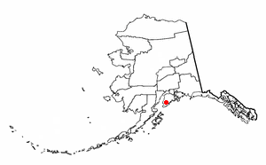
Fox River is a census-designated place (CDP) in Kenai Peninsula Borough, Alaska, United States. At the 2010 census the population was 685, up from 616 in 2000. It was first reported by the U.S. Geological Survey in 1895. The Fox River, which flows by the CDP, might have been named for Theodore Fox, a local mining magnate.

Newark Township is a civil township of Gratiot County in the U.S. state of Michigan. The population was 1,149 at the 2000 census.

<span class="mw-page-title-main">Gerry, New York</span> Town in New York, United States

Gerry is a town in Chautauqua County, New York, United States. The population was 1,789 at the 2020 census. The town is named after Elbridge Gerry, the fifth Vice President of the United States. The town is centrally located in the county and is north of Jamestown.

<span class="mw-page-title-main">Austerlitz, New York</span> Town in New York, United States

Austerlitz is a town in Columbia County, New York, United States. The population was 1,654 at the 2010 census. The town was named after the Battle of Austerlitz.

<span class="mw-page-title-main">Claverack, New York</span> Town in New York, United States

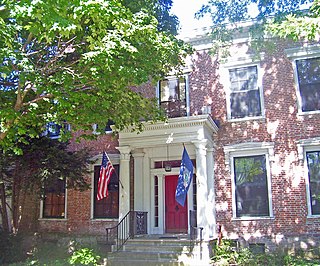
Claverack is a town in Columbia County, New York, United States. The population was 6,021 at the 2010 census. The town name is a corruption for the Dutch word “Klaverakker” for "Clover Fields" or "Clover Reach". In 1705, the first discovery of a mastodon tooth occurred here.

Claverack-Red Mills, commomly known as Claverack, is a census-designated place (CDP) in Columbia County, New York, United States. The population was 913 at the 2010 census.

<span class="mw-page-title-main">Copake, New York</span> Town in New York, United States

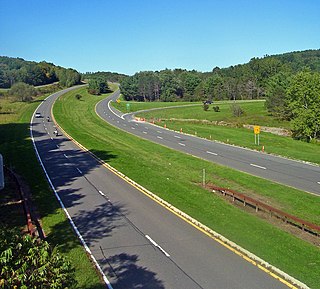
Copake is a town in Columbia County, New York, United States. The population was 3,615 at the 2010 census. The town derives its name from a lake, which was known to the natives as Cook-pake, or Ack-kook-peek, meaning "Snake Pond".

<span class="mw-page-title-main">Gallatin, New York</span> Town in New York, United States

Gallatin is a town in Columbia County, New York, United States. The population was 1,668 at the 2010 census. Gallatin is on the southern border of Columbia County and located 100 miles (160 km) north of New York City.

Lorenz Park is a census-designated place (CDP) in Columbia County, New York, United States. The population was 2,053 at the 2010 census.

<span class="mw-page-title-main">Stockport, New York</span> Town in New York, United States

Stockport is a town in Columbia County, New York, United States. The population was 2,815 at the 2010 census.

Stottville is a hamlet and census-designated place (CDP) in Columbia County, New York, United States. The population was 1,375 at the 2010 census.

<span class="mw-page-title-main">Stuyvesant, New York</span> Town in New York, United States

Stuyvesant is a town in Columbia County, New York, United States. The population was 2,027 at the 2010 census. The town is in the northwest corner of Columbia County. U.S. Route 9 crosses the southeastern corner of the town.

<span class="mw-page-title-main">Taghkanic, New York</span> Town in New York, United States

Taghkanic is a town in Columbia County, New York, United States. The town is in the south-central part of the county. The population was 1,310 at the 2010 census. "Taghkanic" is an older spelling of "Taconic".

Jefferson Heights is a hamlet and census-designated place (CDP) in Greene County, New York, United States. The population was 1,094 at the 2010 census.

Leeds is a hamlet and census-designated place (CDP) in Greene County, New York, United States. The population was 377 at the 2010 census.

<span class="mw-page-title-main">Oriskany Falls, New York</span> Village in New York, United States

Oriskany Falls is a village in Oneida County, New York, United States. The population was 732 at the 2010 census. The name is derived from a waterfall on a nearby stream.

<span class="mw-page-title-main">Saugerties South, New York</span> CDP in New York, United States

Saugerties South is a hamlet in Ulster County, New York, United States. The population was 2,218 at the 2010 census.

<span class="mw-page-title-main">Millston, Wisconsin</span> Town in Wisconsin, United States

Millston is a town in Jackson County, Wisconsin, United States. The population was 136 at the 2000 census. The unincorporated community of Speck Oaks is located in the town. The census-designated place of Millston is also located in the town.

<span class="mw-page-title-main">Ghent, New York</span> Town in New York, United States

Ghent is a town in Columbia County, New York, United States, with a ZIP code of 12075. The population was 5,402 at the 2010 census. Ghent is centrally located in the county and is northeast of the city of Hudson.

References

  1. "ArcGIS REST Services Directory". United States Census Bureau. Retrieved September 20, 2022.
  2. 1 2 "Geographic Identifiers: 2010 Demographic Profile Data (G001): Philmont village, New York". U.S. Census Bureau, American Factfinder. Archived from the original on February 12, 2020. Retrieved December 11, 2014.
  3. "Philmont, New York -- History - The Beginning of Philmont". www.philmont.org. Archived from the original on 2008-07-04.
  4. "US Gazetteer files: 2010, 2000, and 1990". United States Census Bureau. 2011-02-12. Retrieved 2011-04-23.
  5. "Census of Population and Housing". Census.gov. Retrieved June 4, 2015.
  6. "U.S. Census website". United States Census Bureau . Retrieved 2008-01-31.