| Site of Special Scientific Interest | |
 | |
 Location within Somerset | |
| Area of Search | Avon |
|---|---|
| Grid reference | ST532611 |
| Coordinates | 51°20′49″N2°40′24″W / 51.34704°N 2.67335°W Coordinates: 51°20′49″N2°40′24″W / 51.34704°N 2.67335°W |
| Interest | Biological |
| Area | 4.3 hectares (0.043 km2; 0.017 sq mi) |
| Notification | 1989 |
| Natural England website | |
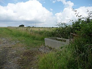
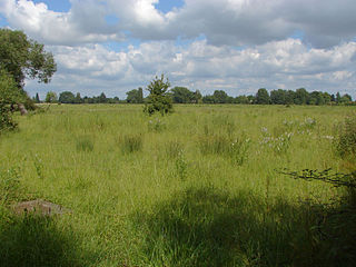
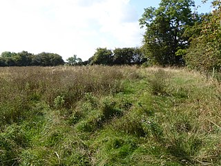
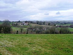
Plaster's Green Meadows (grid reference ST532611 ) is a 4.3 hectare biological Site of Special Scientific Interest near the village of Nempnett Thrubwell, Bath and North East Somerset, notified in 1989.

The Ordnance Survey National Grid reference system is a system of geographic grid references used in Great Britain, distinct from latitude and longitude. It is often called British National Grid (BNG).

The hectare is an SI accepted metric system unit of area equal to a square with 100-metre sides, or 10,000 m2, and is primarily used in the measurement of land. There are 100 hectares in one square kilometre. An acre is about 0.405 hectare and one hectare contains about 2.47 acres.

Nempnett Thrubwell is a small village and civil parish in dairying country on the western edge of Bath and North East Somerset, in the county of Somerset, England. It is about 15 km south-west of Bristol. The parish, which has a population of 177, is sheltered by the Mendip Hills, near the River Yeo in the Chew Valley. It is the site of the Fairy Toot oval barrow.
This is an area of unimproved and traditionally managed species-rich meadows which support a neutral grassland community of a type which is now rare throughout Britain. The site is situated on the slopes fringing the Lias Tablelands and is underlain by Rhaetic clays and, lower down the slope Keuper Red Marl. The slowly permeable clay soils are slightly calcareous in nature and this is reflected in elements of the flora.
The Early Jurassic epoch is the earliest of three epochs of the Jurassic period. The Early Jurassic starts immediately after the Triassic-Jurassic extinction event, 201.3 Ma, and ends at the start of the Middle Jurassic 174.1 Ma.
The Rhaetian is, in geochronology, the latest age of the Triassic period or in chronostratigraphy the uppermost stage of the Triassic system. It lasted from 208.5 to 201.3 million years ago. It was preceded by the Norian and succeeded by the Hettangian.
The Keuper is a lithostratigraphic unit in the subsurface of large parts of west and central Europe. The Keuper consists of dolomite, shales or claystones and evaporites that were deposited during the Middle and Late Triassic epochs. The Keuper lies on top of the Muschelkalk and under the predominantly Lower Jurassic Lias or other Early Jurassic strata.
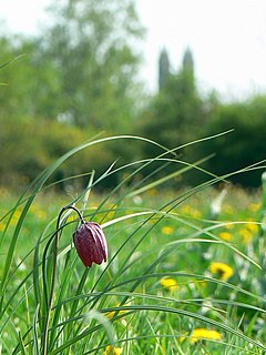
The site is characterised by the nationally rare Common Knapweed (Centaurea nigra) and Crested Dog’s-tail (Cynosurus cristatus) and dominant grasses include Sweet Vernal-grass (Anthoxanthum odoratum), Crested Dog’s-tail and Yorkshire Fog (Holcus lanatus), while Quaking Grass (Briza media) and Yellow Oat-grass (Trisetum flavescens) are also frequent.
There is a high component of herb species throughout the meadows including Saw-wort (Serratuta tinctoria), Dyer’s Greenweed (Genista tinctoria), Common Knapweed, Pepper-saxifrage (Silaum silaus), Devil’s-bit Scabious (Succisa pratensis), Betony (Stachys officinalis) and Spiny Restharrow (Ononis spinosa). The calcareous nature of the soil is reflected by the presence of Cowslip (Primula veris), Fairy Flax (Linum catharticum), Glaucous Sedge (Carex flacca), Lady’s Bedstraw (Galium verum) and occasional Salad Burnet (Sanguisorba minor).

Serratula tinctoria, commonly known as dyer's plumeless saw-wort or saw-wort, is a species in the genus Serratula. It is a native of Europe and a thistle like flower head. It grows in moist soil, full sun to part shade, and grows up to one metre tall.

Stachys officinalis is commonly known as common hedgenettle, betony, purple betony, wood betony, bishopwort, or bishop's wort. The French common name is bétoine, and Betonie in German. It is a perennial grassland herb.
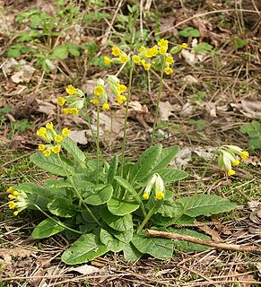
Primula veris is a herbaceous perennial flowering plant in the primrose family Primulaceae. The species is native throughout most of temperate Europe and western Asia, and although absent from more northerly areas including much of northwest Scotland, it reappears in northernmost Sutherland and Orkney and in Scandinavia. This species frequently hybridizes with other Primulas such as Primula vulgaris to form false oxlip which is often confused with true oxlip, a much rarer plant.
The meadows are bounded by hedges supporting numerous species including Hawthorn ( Crataegus monogyna ), Wych Elm (Ulmus glabra), English Elm (Ulmus procera), Hazel (Corylus avellana) and Field Maple (Acer campestre). Hedgerow trees include Ash (Fraxinus excelsior), Sweet Chestnut (Castanea sativa), Holly (Ilex aquifolium) and Oak (Quercus spp.).

Crataegus monogyna, known as common hawthorn, oneseed hawthorn, or single-seeded hawthorn, is a species of hawthorn native to Europe, northwest Africa and western Asia. It has been introduced in many other parts of the world. It can be an invasive weed.
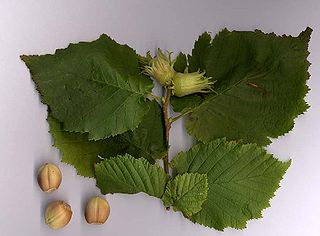
Corylus avellana, the common hazel, is a species of hazel native to Europe and western Asia, from the British Isles south to Iberia, Greece, Turkey and Cyprus, north to central Scandinavia, and east to the central Ural Mountains, the Caucasus, and northwestern Iran. It is an important component of the hedgerows that were the traditional field boundaries in lowland England. The wood was traditionally grown as coppice, the poles cut being used for wattle-and-daub building and agricultural fencing.

Ilex aquifolium, is a species of holly native to western and southern Europe, northwest Africa, and southwest Asia. It is regarded as the type species of the genus Ilex, which by association is also called "holly". It is an evergreen tree or shrub found, for example, in shady areas of forests of oak and in beech hedges. In the British Isles it is one of very few native evergreen trees. It has a great capacity to adapt to different conditions and is a pioneer species that repopulates the margins of forests or clearcuts.