Plymouth, Illinois

Last updated

Plymouth, Illinois
McDonough County Illinois Incorporated and Unincorporated areas Plymouth Highlighted.svg
Location in Hancock and McDonough counties, Illinois
Usa edcp location map.svg
Red pog.svg
Plymouth
Location in the United States
Coordinates: 40°17′28″N90°55′2″W / 40.29111°N 90.91722°W / 40.29111; -90.91722
CountryUnited States
StateIllinois
Counties Hancock, McDonough
Townships St. Mary, Lamoine
Area
[1]
  Total0.56 sq mi (1.46 km2)
  Land0.56 sq mi (1.46 km2)
  Water0.00 sq mi (0.00 km2)
Elevation
[2]
643 ft (196 m)
Population
 (2020) [3]
  Total436
  Density771.68/sq mi (298.17/km2)
Time zone UTC-6 (CST)
  Summer (DST) UTC-5 (CDT)
ZIP code
62367
Area code 309
FIPS code 17-60833
GNIS feature ID2398989 [2]
Wikimedia CommonsPlymouth, Illinois

Plymouth is a village in Hancock and McDonough counties, Illinois, United States. The population was 436 at the 2020 census, [3] down from 505 in 2010. [4]

Contents

Geography

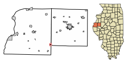
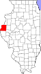
Plymouth is located in southeastern Hancock County at 40°17′28″N90°55′02″W / 40.291228°N 90.917134°W / 40.291228; -90.917134 . [5] A small portion of the village extends east into the southwest corner of McDonough County. Illinois Route 61 passes through the village, leading northeast 4.5 miles (7.2 km) to Colmar and southwest 5 miles (8 km) to Augusta. Carthage, the Hancock County seat, is 21 miles (34 km) to the northwest of Plymouth.

According to the U.S. Census Bureau, Plymouth has a total area of 0.56 square miles (1.45 km2), all land. [1] The village drains north toward Bronson Creek and south toward Flour Creek, both east-flowing tributaries of the La Moine River and part of the Illinois River watershed.

Demographics

Historical population
CensusPop.Note
1880 593
1890 71019.7%
1900 85420.3%
1910 829−2.9%
1920 9008.6%
1930 745−17.2%
1940 8088.5%
1950 8545.7%
1960 781−8.5%
1970 740−5.2%
1980 649−12.3%
1990 521−19.7%
2000 5627.9%
2010 505−10.1%
2020 436−13.7%
U.S. Decennial Census [6]

As of the census [7] of 2000, there were 562 people, 234 households, and 146 families residing in the village. The population density was 953.8 inhabitants per square mile (368.3/km2). There were 264 housing units at an average density of 448.1 per square mile (173.0/km2). The racial makeup of the village was 95.73% White, 0.18% African American, 0.18% Native American, 1.25% Asian, 0.53% from other races, and 2.14% from two or more races. Hispanic or Latino of any race were 0.89% of the population.

There were 234 households, out of which 31.2% had children under the age of 18 living with them, 51.3% were married couples living together, 9.0% had a female householder with no husband present, and 37.6% were non-families. 32.5% of all households were made up of individuals, and 17.9% had someone living alone who was 65 years of age or older. The average household size was 2.40 and the average family size was 3.00.

In the village, the population was spread out, with 28.5% under the age of 18, 8.2% from 18 to 24, 26.2% from 25 to 44, 19.6% from 45 to 64, and 17.6% who were 65 years of age or older. The median age was 36 years. For every 100 females, there were 93.1 males. For every 100 females age 18 and over, there were 87.0 males.

The median income for a household in the village was $24,500, and the median income for a family was $30,139. Males had a median income of $24,479 versus $22,083 for females. The per capita income for the village was $12,150. About 16.8% of families and 18.8% of the population were below the poverty line, including 23.2% of those under age 18 and 12.5% of those age 65 or over.

Education

Residents attend Southeastern High School which is located in nearby Augusta.

Related Research Articles

<span class="mw-page-title-main">Hancock County, Illinois</span> County in Illinois, United States

Hancock County is a county in the U.S. state of Illinois. According to the 2020 census, it has a population of 17,620. Its county seat is Carthage, and its largest city is Hamilton. The county is composed of rural towns with many farmers.

<span class="mw-page-title-main">Augusta, Illinois</span> Village in Illinois, United States

Augusta is a village in southeast Hancock County, Illinois, United States. The population was 587 at the 2010 census, down from 657 at the 2000 census. It is located near Weinberg-King State Park.

<span class="mw-page-title-main">Bowen, Illinois</span> Village in Illinois, United States

Bowen is a village in southeast Hancock County, Illinois, United States. The population was 494 at the 2010 census.

<span class="mw-page-title-main">Livingston, Illinois</span> Village in Illinois, United States

Livingston is a village in Madison County, Illinois, United States. The population was 763 at the 2020 census, down from 858 in 2010.

<span class="mw-page-title-main">St. Jacob, Illinois</span> Village in Illinois, United States

St. Jacob or Saint Jacob is a village in Madison County, Illinois, United States. The population was 1,358 at the 2020 census, up from 1,098 in 2010.

<span class="mw-page-title-main">Williamson, Illinois</span> Village in Illinois, United States

Williamson is a village in Madison County, Illinois, United States. The population was 183 at the 2020 census, down from 230 in 2010.

<span class="mw-page-title-main">Kell, Illinois</span> Village in Illinois, United States

Kell is a village in Marion County, Illinois, United States. The population was 173 at the 2020 census, down from 219 in 2010.

<span class="mw-page-title-main">Washburn, Illinois</span> Village in Illinois, United States

Washburn is a village mostly in Woodford County, with a small northerly portion in Marshall County, Illinois, United States. The population was 1,032 at the 2020 census. It is part of the Peoria Metropolitan Statistical Area.

<span class="mw-page-title-main">Easton, Illinois</span> Village in Illinois, United States

Easton is a village in Mason County, Illinois, United States. As of the 2020 census, the village population was 312.

<span class="mw-page-title-main">Kilbourne, Illinois</span> Village in Illinois, United States

Kilbourne is a village in Mason County, Illinois, United States. The population was 265 at the 2020 census, down from 302 in 2010.

<span class="mw-page-title-main">Bardolph, Illinois</span> Village in Illinois, United States

Bardolph is a village in McDonough County, Illinois, United States. The population was 210 at the 2020 census, down from 251 in 2010.

<span class="mw-page-title-main">Blandinsville, Illinois</span> Village in Illinois, United States

Blandinsville is a village in McDonough County, Illinois, United States. The population was 569 at the 2020 census, down from 651 in 2010.

<span class="mw-page-title-main">Good Hope, Illinois</span> Village in Illinois, United States

Good Hope is a village in McDonough County, Illinois, United States. Its population was 363 at the 2020 census.

<span class="mw-page-title-main">Industry, Illinois</span> Village in Illinois, United States

Industry is a village in McDonough County, Illinois, United States. As of the 2020 census, the village population was 399, down from 478 in 2010.

<span class="mw-page-title-main">Prairie City, Illinois</span> Village in Illinois, United States

Prairie City is a village in McDonough County, Illinois, United States. The population was 407 at the 2020 census.

<span class="mw-page-title-main">Tennessee, Illinois</span> Village in Illinois, United States

Tennessee is a village in McDonough County, Illinois, United States. The population was 101 at the 2020 census.

<span class="mw-page-title-main">Matherville, Illinois</span> Village in Illinois, United States

Matherville is a village in Mercer County, Illinois, United States. The population was 707 at the 2020 census.

<span class="mw-page-title-main">Hecker, Illinois</span> Village in Illinois, United States

Hecker is a village in Monroe County in the U.S state of Illinois. The population was 429 at the 2020 census, down from 481 in 2010.

<span class="mw-page-title-main">Maeystown, Illinois</span> Village in Illinois, United States

Maeystown is a village in Monroe County, Illinois, United States. The population was 150 at the 2020 census.

<span class="mw-page-title-main">Walshville, Illinois</span> Village in Illinois, United States

Walshville is a small village in Montgomery County, Illinois, United States. The population was 61 at the 2020 census.

References

  1. 1 2 "2022 U.S. Gazetteer Files: Illinois". United States Census Bureau. Retrieved March 6, 2023.
  2. 1 2 U.S. Geological Survey Geographic Names Information System: Plymouth, Illinois
  3. 1 2 "P1. Race – Plymouth village, Illinois: 2020 DEC Redistricting Data (PL 94-171)". U.S. Census Bureau. Retrieved March 6, 2023.
  4. "P1. Race – Plymouth village, Illinois: 2010 DEC Redistricting Data (PL 94-171)". U.S. Census Bureau. Retrieved March 6, 2023.
  5. "US Gazetteer files: 2010, 2000, and 1990". United States Census Bureau. February 12, 2011. Retrieved April 23, 2011.
  6. "Census of Population and Housing". Census.gov. Retrieved June 4, 2015.
  7. "U.S. Census website". United States Census Bureau . Retrieved January 31, 2008.