
The Malankara Orthodox Syrian Church (MOSC) also known as the Indian Orthodox Church (IOC) or simply as the Malankara Church, is an autocephalous Oriental Orthodox church headquartered in Devalokam, near Kottayam, India. It serves India's Saint Thomas Christian population. According to tradition, these communities originated in the missions of Thomas the Apostle in the 1st century. It employs the Malankara Rite, an Indian form of the West Syriac liturgical rite.

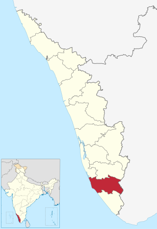
Pathanamthitta District, is one of the 14 districts in the Indian state of Kerala. The district headquarters is in the town of Pathanamthitta. There are four municipalities in Pathanamthitta: Adoor, Pandalam, Pathanamthitta and Thiruvalla.
Mavelikara is a municipality in the Alappuzha district of Kerala, India. It is located 36 km (22.4 mi) south of the district headquarters in Alappuzha and about 95 km (59.0 mi) north of the state capital Thiruvananthapuram. As per the 2011 Indian census, Mavelikkara has a population of 26,421 people, and a population density of 2,088/km2 (5,410/sq mi).
Kollam district, is one of 14 districts of the state of Kerala, India. The district has a cross-section of Kerala's natural attributes; it is endowed with a long coastline, a major Laccadive Sea seaport and an inland lake. The district has many water bodies. Kallada River is one among them, and land on the east bank of the river is East Kallada and that on the west bank is West Kallada.
Adoor is a municipality in the Pathanamthitta district of Kerala, India. It is the headquarters of the Adoor Taluk and Adoor Revenue Division. Adoor is located 18 km (11.2 mi) southwest of the district headquarters Pathanamthitta and 85 km (52.8 mi) north of the state capital Thiruvananthapuram.

Chengannur is a municipality in the Alappuzha district of Kerala, India. It is located 37 km (23.0 mi) south of the district headquarters in Alappuzha and about 98 km (60.9 mi) north of the state capital Thiruvananthapuram. As per the 2011 Indian census, Chengannur has a population of 23,466 people, and a population density of 1,607/km2 (4,160/sq mi).

Pathanamthitta, is a municipality situated in the Southern Kerala, India, spread over an area of 23.50 km2. It is the administrative capital of Pathanamthitta district. The town has a population of 37,538. The Hindu pilgrim centre Sabarimala is situated in the Pathanamthitta district; as the main transport hub to Sabarimala, the town is known as the 'Pilgrim Capital of Kerala'. Pathanamthitta District, the thirteenth revenue district of the State of Kerala, was formed with effect from 1 November 1982, with headquarters at Pathanamthitta. Forest covers more than half of the total area of the District. Pathanamthitta District ranks the 7th in area in the State. The district has its borders with Allepey, Kottayam, Kollam and Idukki districts of Kerala and Tamil Nadu. Nearest town is Thiruvalla, located at a distance of 30 km. Thiruvalla railway station is 30 km via Thiruvalla-Kumbazha highway. Buses ply every 5 Minutes from Thiruvalla To Pathanamthitta & vice versa.
Punnala is a small village situated in Kollam district of Kerala, India. Punnala is located at a distance of 8 kilometers from both Pathanapuram and Punalur and 1 km from Chachipunna. It is in the Pathanapuram Taluk, Pathanapuram Assembly Constituency and Mavelikkara Parliament Constituency. Punnala is a part of Piravanthoor Grama Panchayth, Pathanapuram Block Panchayat and Kollam district Panchayat.

Thalavoor is a village located in the district of Kollam in the Kerala state of India. It is 77 km to the north of the State Capital, Thiruvananthapuram, and 28 km to the east of District Capital, Kollam. Thalavoor village is bordered by Pattazhy village to the north, Pidavoor village to the north-east, Vilakkudy village to the south-east, Melila village to the south and Mylom village to the west. Thalavoor is a part of Pathanapuram Block Panchayat

Pathanapuram is a Town in Pathanapuram Taluk Kollam district, Kerala, India. Pathanapuram is a part of Grama Panchayat and Block panchayat of same name and part of Kollam District Panchayat.

Chathannoor is a town in the Indian state of Kerala situated at the Kollam District on the banks of Ithikkara River. It is about 16 km (9.9 mi) from Kollam(Quilon) City. Chathannoor is around 55 km (34 mi) north of the state capital Thiruvananthapuram(Trivandrum). Chathannoor is a Special Grade Panchayath and is one of the fastest developing towns in Kerala.. Shri ChandraKumar is the current president of Chathannoor Grama Panchayat.
Pattazhy, also Pattazhi is a village located in Pathanapuram taluk in the eastern part of the Kollam District, Kerala state, India. It is best known as the site of an ancient Bhagavathy temple, Pattazhy Devi Temple.
Chachipunna is a small village in the Kollam (Quilon) district of India's Kerala state with a population of approximately 1000.
Kudavattoor is a small village of the Kottarakara Taluk in the Kollam district of the Indian state of Kerala. In the local Malayalam language, kuda means "umbrella" and vattor "round". A predominantly rural village, Kudavattoor comes under the administration of the Veliyam Grama Panchayat made up of Maroor, Cherukarakonam and Kudavattoor chandhamukku. The village is situated on the odanavattom kollam road, which provides access to Kollam via Kundara or Nedumankavu as well as to Kottarakara. Kollam, the district headquarters is situated about 25 km from Kudavattoor.
Vettikkavala is a village located in the Kollam district in the state of Kerala, India. One point of interest within the village is a Shiva-Vishnu temple which hosts a special deity called Vathukkal Njali Kunju. An annual celebration of Pongala is held at the temple. The village is also well known for temple arts and a palace constructed by Sree Moolam Thirunal.
Karavaloor is a village situated in Kollam district in the Indian state of Kerala.
Keezhvaipur is a village in the Mallappally Taluk which is one of five Taluks that makes up the Pathanamthitta district, in Kerala State, India.It Is Part Of Thiruvalla Constituency.Keezhuvaipur lies in the bank of river Manimala and is famous for its traditions, cultures, and customs. The town is located on the Kottayam-Punalur State Highway. Keezhuvaipur is 3 km away from Mallappally, 11 km from Kozhencherry and 13 km from Tiruvalla.

Arohana Marthoma Church is a church situated in Anicadu Village, 5 km from Nedumkunnam and 4 km from Mallappally in Pathanamthitta district in the southern part of Kerala, India. It is a Malankara Mar Thoma Syrian Church under Kottayam- Kochi Dioceses. Arohana Marthoma Church has a total of about 176 families with more than 932 members.

Transport in Kollam includes various modes of road, rail and water transportation in the city and its suburbs. State-owned Kerala State Road Transport Corporation buses, private buses, Indian Railways, state-owned Kerala State Water Transport Department boats & ferry, taxis and auto rickshaws are serving the city of Kollam. The city had a strong commercial reputation since the days of the Phoenicians and Romans. Ibn Battuta mentioned Kollam Port as one of the five Indian ports he had seen during the course of his twenty-four year travels.
Ēḻarappaḷḷikaḷ or Ezharappallikal, are the seven major churches or Christian communities of Saint Thomas Christians across Malabar Coast of India that are believed to have been founded by Thomas the Apostle in the first century. According to Indian Christian traditions, the apostle Thomas arrived in Muziris (Kodungallur) in AD 52, established the Ezharappallikal and evangelised in present-day Kerala and Tamil Nadu. Many of these churches built near Jewish and Brahmin settlements. These were at Maliankara (Kodungallur), Kollam, Palayoor, Kottakkayal, Kokkamangalam, Niranam and Nilackal (Chayal). Thiruvithamcode church in Kanyakumari was built on the land given by arachan (king) and hence it is often referred in the name Arappally. Similarly, the Churches at Malayattoor and Aruvithura are also referred to as Arappallikal.


