
West Quoddy Head, in Quoddy Head State Park, Lubec, Maine, is the easternmost point of the contiguous United States. In 1808 a lighthouse was constructed at the site to guide ships through the Quoddy Narrows. The current tower, with distinctive red-and-white stripes, was constructed in 1858 and is an active aid to navigation. The 3rd order Fresnel lens is the only 3rd order and one of only eight Fresnel lenses still in use on the Maine Coast.

Bradbury Mountain State Park is a public recreation area in the town of Pownal, Cumberland County, Maine, managed by the Department of Agriculture, Conservation and Forestry. The state park covers 730 acres (300 ha).

Eagle Island is an island in Maine's Casco Bay and the site of the retirement home of the polar explorer Admiral Robert Peary (1856-1920). The island and home are preserved as the Eagle Island State Historic Site.

The Fort Point Light, or Fort Point Light Station, is located in Fort Point State Park, in Stockton Springs, Maine. A lighthouse at this point has served as an active aid to navigation since 1835; the present lighthouse dates to 1857, and is listed on the National Register of Historic Places.

The North Canal Historic District of Lawrence, Massachusetts, encompasses the historic industrial heart of the city. It is centered on the North Canal and the Great Stone Dam, which provided the waterpower for its many mill complexes. The canal was listed on the National Register of Historic Places in 1975, while the district was first listed in 1984, and then expanded slightly in 2009.

Bear Island Light is a lighthouse on Bear Island near Mt. Desert Island, at the entrance to Northeast Harbor, Maine. It was first established in 1839. The present structure was built in 1889. It was deactivated in 1981 and relit as a private aid to navigation by the Friends of Acadia National Park in 1989. Bear Island Light was listed on the National Register of Historic Places as Bear Island Light Station on March 14, 1988.

Watson Settlement Bridge is a historic covered bridge in eastern Littleton, Maine, United States. Built in 1911, it is one of the youngest of Maine's few surviving covered bridges. It formerly carried Framingham Road over the Meduxnekeag River, but is now closed to traffic, the road passing over a modern bridge to its south. It was listed on the National Register of Historic Places in 1970.

The David L. Shirk Ranch is a historic ranch located in the Guano Valley of eastern Lake County, Oregon, United States. The ranch was originally homesteaded in 1881. It was purchased by David L. Shirk in 1883. He operated the ranch until 1914. The property was acquired by the United States Government in 1942. The ranch is now administered by the Bureau of Land Management. The remaining historic ranch buildings are listed on the National Register of Historic Places.

Frogmore Mound Site is an archaeological site of the Late Coles Creek culture in Concordia Parish, Louisiana. The site is located 7 miles (11 km) west of Ferriday on US 84. It was added to the National Register of Historic Places on July 28, 2004.
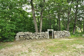
Turner Cattle Pound is a historic animal pound at the corner of Gen. Turner Hill Road and Kennebec Trail in Turner, Maine. Built in 1816, it is a well-preserved example of a once-common feature of New England's agricultural communities. It was listed on the National Register of Historic Places in 2009.
The Farmington Town Pound is an historic animal pound in Farmington, New Hampshire. It is located on the north side of Pound Road near its intersection with Ten Rod Road. Built in 1823, it is one of the best-preserved 19th-century pounds in southeastern New Hampshire, and is now maintained by the Farmington Historical Society. It was listed on the National Register of Historic Places in 1993.

The Churchill Bridge is a historic bridge carrying Mountain Road over Bicknell Brook, in a rural corner of Buckfield, Maine. It is one of three documented stone lintel bridges in the state. It is a dry laid rubble stone structure which carries the road over the stream at a height of about 14 feet (4.3 m). The total length of the bridge is about 20 feet (6.1 m), and the clear span over the brook is 5 feet (1.5 m). The span is formed by five massive ledge stones laid on rubble abutments about 7 feet (2.1 m) above the stream. Additional rubble is laid above to form the bed of the gravel roadway. The bridge crosses the stream at a slight angle, so its abutments are extended with wingwalls to the northwest and southeast.

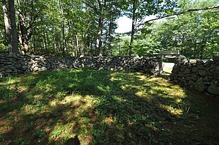
The Greenwood Cattle Pound is an animal pound located on Greenwood Road, 0.3 miles (0.48 km) east of Maine State Route 219 in Greenwood, Maine. Completed in 1836, the roughly square stone structure is a reminder of the town's agrarian past. It was listed on the National Register of Historic Places in 2007.

The Ellsworth Power House and Dam, the latter also known as the Union River Dam, is a hydroelectric power generation facility on the Union River in Ellsworth, Maine. The dam, located just north of downtown Ellsworth, impounds the river to create Leonard Lake, named for project's engineer, James Leonard. The powerhouse is a Renaissance Revival building located at the western end of the dam. The power plant, built in 1907, was one of the first peaking power plants built in the state, and the hollow concrete dam is one of the highest Ambursen-type buttress dams ever built. The facility was listed on the National Register of Historic Places in 1985.

The Charlotte Pound is a historic animal pound on Charlotte Road in Charlotte, Maine. Built in 1872 out of logs on a stone foundation, it is the only documented wooden pound in the state. It was listed on the National Register of Historic Places in 2005.

Mallett Hall is the town hall of Pownal, Maine. It is an architecturally distinctive Colonial Revival building, constructed in 1886 in the crossroads village of Pownal Center. It was listed on the National Register of Historic Places in 1991 for its architecture.
A poundmaster, or poundkeeper, was a local government official responsible for the feeding and care of stray livestock such as domestic pigs, cattle, horses, sheep, and geese. This was common in colonial America and continued into the 19th century.
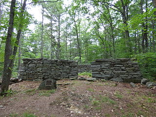
The Jefferson Cattle Pound is a historic animal pound in Jefferson, Maine. Built in 1829, it is one of the state's best-preserved stone pounds. It is located on the south side of Gardiner Road, about 0.75 miles (1.21 km) west of its junction with Maine State Route 213. It was listed on the National Register of Historic Places in 2004.
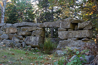
The Waldoborough Town Pound is a historic animal pound on Main Street in Waldoboro, Maine. Built in 1819, the stone structure is an important reminder of the town's agricultural past, and one of a few such structures of its type to survive in the state. It was listed on the National Register of Historic Places in 1976.
The Little Mark Island Monument is a historic day beacon and shipwreck refuge on Little Mark Island in northern Casco Bay off the southern coast of the United States state of Maine. The monument, a pyramidal stone structure built in 1827, is one of only three such structures ever built in the state, and is now topped by a beacon light. It is owned and managed by the United States Coast Guard, and is an active aid to navigation. It was listed on the National Register of Historic Places in 2016.


