
Monument Avenue is a tree-lined grassy mall dividing the eastbound and westbound traffic in Richmond, Virginia, originally named for its emblematic complex of structures honoring those who fought for the Confederacy during the American Civil War. Between 1900 and 1925, Monument Avenue greatly expanded with architecturally significant houses, churches, and apartment buildings. Four of the bronze statues representing J. E. B. Stuart, Stonewall Jackson, Jefferson Davis and Matthew Fontaine Maury were removed from their memorial pedestals amidst civil unrest in July 2020. Two others still retain their bronze statues: the Robert E. Lee monument dedicated in 1890 and the Arthur Ashe monument memorializing the African American tennis champion dedicated in 1996.

The Sons of Confederate Veterans (SCV) is an American nonprofit and charitable organization of male blood-descendants of Confederate veterans headquartered at the Elm Springs in Columbia, Tennessee. The SCV was founded on July 1, 1896, at the City Auditorium in Richmond, Virginia, by R. E. Lee Camp, No. 1, Confederate Veterans. It is known for erecting and maintaining American Civil War memorials and graves, observing Confederate Memorial Day, and encouraging Southern historical study. In recent decades, governors, legislators, courts, corporations, and anti-racism activists have placed new emphasis on the increasingly controversial public display of Confederate symbols—especially after the 2014 Ferguson unrest, the 2015 Charleston church shooting, and the 2020 killing of George Floyd. SCV has responded with its coordinated display of larger and more prominent public displays of the battle flag, some in directly defiant counter-protest.

The White House of the Confederacy is a historic house located in the Court End neighborhood of Richmond, Virginia. Built in 1818, it was the main executive residence of the sole President of the Confederate States of America, Jefferson Davis, from August 1861 until April 1865. It was viewed as the Confederate States counterpart to the White House in Washington, D.C.

The Jefferson Davis Highway, also known as the Jefferson Davis Memorial Highway, was a planned transcontinental highway in the United States in the 1910s and 1920s that began in Arlington, Virginia, and extended south and west to San Diego, California; it was named for Jefferson Davis, President of the Confederate States, United States senator, and Secretary of War. Because of unintended conflict between the National Auto Trail movement and the federal government, it is unclear whether it ever really existed in the complete form that its United Daughters of the Confederacy (UDC) founders originally intended.

Buildings, sites, districts, and objects in Virginia listed on the National Register of Historic Places:

St. Paul's Episcopal Church is an historic Episcopal church in Richmond, Virginia, United States. Located directly across the street from the Virginia State Capitol, it has long been a popular house of worship for political figures, including General Robert E. Lee and Confederate President Jefferson Davis. Davis was a member.

The boundary markers of the original District of Columbia are the 40 milestones that marked the four lines forming the boundaries between the states of Maryland and Virginia and the square of 100 square miles (259 km²) of federal territory that became the District of Columbia in 1801. Working under the supervision of three commissioners that President George Washington had appointed in 1790 in accordance with the federal Residence Act, a surveying team that Major Andrew Ellicott led placed these markers in 1791 and 1792. Among Ellicott's assistants were his brothers Joseph and Benjamin Ellicott, Isaac Roberdeau, George Fenwick, Isaac Briggs and an African American astronomer, Benjamin Banneker.

Aquia Church is a historic church and congregation at 2938 Jefferson Davis Highway in Stafford, Virginia, USA. It is an Episcopal congregation founded in 1711, that meets in an architecturally exceptional Georgian brick building that was built in the 1750s. The building was designated a National Historic Landmark in 1991 for its architectural importance. It maintains an active congregation with a variety of programs and outreach to the community.

This is a list of the National Register of Historic Places listings in Henrico County, Virginia.
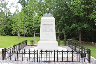
Jefferson Davis Memorial Historic Site is a 12.668-acre (5.127 ha) state historic site located in Irwin County, Georgia that marks the spot where Confederate States President Jefferson Davis was captured by United States Cavalry on Wednesday, May 10, 1865. The historic site features a granite monument with a bronze bust of Jefferson Davis that is located at the place of capture. The memorial museum, built in 1939 by the Works Progress Administration, features Civil War era weapons, uniforms, artifacts and an exhibit about the president's 1865 flight from Richmond, Virginia to Irwin County, Georgia.
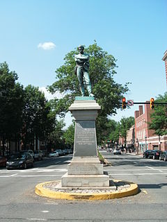
Appomattox is a bronze statue commemorating soldiers from Alexandria, Virginia, who had died while fighting for the Confederacy during the American Civil War. The memorial was located in the center of the intersection of South Washington Street and Prince Street in the Old Town neighborhood of Alexandria.

The Brook Road Marker, Jefferson Davis Highway is a commemorative marker on the Jefferson Davis Highway, in Henrico County, Virginia, outside of Richmond, Virginia. The Jefferson Davis Highway was conceived and marked by the United Daughters of the Confederacy, as a counter to the Lincoln Highway in the north, during 1913–1925. In that era, named highways were being marked as automobile travel increased, and the advent of numbered highways eventually loomed. The marker was placed in North Richmond Brook Road, south of Hilliard Road, in 1927. It is one of the earliest, out of 16, that were placed to mark the highway in Virginia by the United Daughters of the Confederacy. It is a 42-inch-high (1.1 m) gray granite stone, with a slanted top, and a bronze plaque.

The Bridge at Falling Creek is a historic stone arch bridge located near Richmond, in Chesterfield County, Virginia. It was built about 1823 of rough-cut, uncoursed granite. It is carried by two semicircular barrel arches with voussoirs of rough-finished granite. Its width including parapets is 24 feet (7.3 m), and its llength is 148 feet (45 m). It carried the southbound lanes of U.S. Route 301 until 1977, when it was put out of service. It is accessible from a wayside that includes the Falling Creek UDC Jefferson Davis Highway Marker. The bridge was partially damaged in 2004 but still remains significant. It was listed on the National Register of Historic Places in 1995.

Falling Creek UDC Jefferson Davis Highway Marker is a historic stone highway marker located near Richmond, in Chesterfield County, Virginia. It was erected in 1933, and is one of sixteen erected by the United Daughters of the Confederacy in Virginia along the Jefferson Davis Highway between 1927 and 1946. The marker is a gray granite boulder with rough-cut edges. The stone is engraved with the text “ERECTED BY THE FIRST DISTRICT VIRGINIA DIVISION UNITED DAUGHTERS OF THE CONFEDERACY 1933.” It is located in a wayside established in 1934, that provides access to the Bridge at Falling Creek. It was the first highway wayside park in Virginia.

Maury Street Marker, Jefferson Davis Highway is a historic route marker located on U.S. Route 1, or Jefferson Davis Highway, in Richmond, Virginia. It was erected in 1935, by the United Daughters of the Confederacy (UDC). It is one of 16 erected in Virginia along the Jefferson Davis Highway between 1927 and 1947. The marker is an inscribed granite slab with smooth flat faces and rough-cut edges. It measures 45 inches (110 cm) tall, 25 inches (64 cm) wide and 9 inches (23 cm) thick. The stone is engraved with the text "Jefferson Davis Highway Erected by Elliott Grays Chapter United Daughters of the Confederacy 1935".

Elliott Grays Marker-Jefferson Davis Highway is a historic route marker located on U.S. Route 1, or Jefferson Davis Highway, in Richmond, Virginia. It was erected in 1929, by the United Daughters of the Confederacy. It is one of 16 erected in Virginia along the Jefferson Davis Highway between 1927 and 1947. The marker is an inscribed granite slab with smooth flat faces and rough-cut edges. It measures 47 inches tall, 25 inches wide and 12 inches thick. The stone is engraved with the text "Jefferson Davis Highway This tree marks the site of Battery 17 of the inner defenses of Richmond, 1862-65, and is planted in soil taken from battlefields A memorial to Confederate Soldiers by the Elliott Grays Chapter U.D.C. 1929."
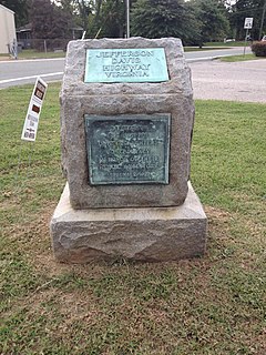
The Jefferson Davis Highway Marker is a commemorative marker on the Jefferson Davis Highway, in Hanover County, Virginia, near Ashland. It is a 42-inch-high (1.1 m) gray granite stone, with a slanted top, with two bronze plaques. The Jefferson Davis Highway was conceived and marked by the United Daughters of the Confederacy, as a counter to the Lincoln Highway in the north, during 1913–1925. In that era, named highways were being marked as automobile travel increased, and the advent of numbered highways eventually loomed. The marker was placed at the junction of what is now US Route 1 and Cedar Lane, between Richmond and Ashland, in 1927. It has been moved twice: in the 1970s it was moved to accommodate the widening of Route 1, and it was moved across Route 1 in the 1980s.

Jefferson Davis Park is a private park located outside Ridgefield, Washington, in the southwestern portion of the state. The granite markers of the unofficial Jefferson Davis Memorial Highway are at the center of the park surrounded by Confederate flags. Operated by the Pacific Northwest chapter of the Sons of Confederate Veterans, the park commemorates Jefferson Davis, the president of the Confederate States of America.


