Mendocino County is a county located on the North Coast of the U.S. state of California. As of the 2010 census, the population was 87,841. The county seat is Ukiah.

Fort Bragg, officially the City of Fort Bragg, lies on the Pacific Coast of California along Shoreline Highway in Mendocino County. It is 24 mi (39 km) west of Willits, at an elevation of 85 feet. Its population was 7,273 at the 2010 census.

Fayetteville is a city in Cumberland County, North Carolina, United States. It is the county seat of Cumberland County, and is best known as the home of Fort Bragg, a major U.S. Army installation northwest of the city.
Fort Bragg, North Carolina, is a military installation of the United States Army in North Carolina, and is one of the largest military installations in the world, with around 57,000 military personnel. It is located within Cumberland, Hoke, Harnett, and Moore counties and borders the towns of Fayetteville, Spring Lake, and Southern Pines. It was also a census-designated place in the 2000 census, during which a residential population of 29,183 was identified. It is named for native North Carolinian Confederate General Braxton Bragg, who had previously served in the United States Army in the Mexican-American War. Fort Bragg is one of ten United States Army installations named for officers who led military units of the Confederacy in the American Civil War.

The Battle of Wilmington was fought February 11–22, 1865, during the American Civil War, mostly outside the city of Wilmington, North Carolina, between the opposing Union and Confederate Departments of North Carolina. The Union victory in January in the Second Battle of Fort Fisher meant that Wilmington, 30 miles upriver, could no longer be used by the Confederacy as a port. It fell to Union troops after they overcame Confederate defenses along the Cape Fear River south of the city. The Confederate General Braxton Bragg burned stores of tobacco and cotton, among other supplies and equipment, before leaving the city, to prevent the Union from seizing them.

The California Western Railroad, popularly called the Skunk Train, is a freight and heritage railroad in Mendocino County, California, United States, running from the railroad's headquarters in the coastal town of Fort Bragg to the interchange with the Northwestern Pacific Railroad at Willits.

State Route 20 is a state highway in the northern-central region of the state of California, running east–west north of Sacramento from the North Coast to the Sierra Nevada. Its west end is at SR 1 in Fort Bragg, from where it heads east past Clear Lake, Colusa, Yuba City, Marysville and Nevada City to I-80 near Emigrant Gap, where eastbound traffic can continue on other routes to Lake Tahoe or Nevada.

United States Army Forces Command (FORSCOM) is the largest United States Army command. It provides expeditionary, regionally engaged, campaign-capable land forces to combatant commanders. Headquartered at Fort Bragg, North Carolina, FORSCOM consists of more than 750,000 active Army, U.S. Army Reserve, and Army National Guard soldiers. FORSCOM was created on 1 July 1973 from the former Continental Army Command, who in turn supplanted Army Field Forces and Army Ground Forces.

The Sierra Northern Railway is a common carrier railroad company operating in California. The company owns several right of ways originating from those of the former Sacramento Northern Railroad, Northern Electric Railway, Sierra Railway Company Of California, Western Pacific Railroad, and Yolo Shortline Railroad. It handles all freight operations and track maintenance for its parent company, the Sierra Railroad Company. The tracks that are maintained by Sierra Northern are also used by the Sierra Railroad Company's tourist trains.

Area code 707 is a telephone area code in the North American Numbering Plan (NANP) for the northwestern part of the U.S. state of California. It was created by a split of area code 415 on March 1, 1959. It serves part of the northern San Francisco Bay Area, as well as the North Coast. Major cities in the area code include Napa, Sebastopol, Vallejo, Benicia, Fairfield, Santa Rosa, Windsor, Healdsburg, Rohnert Park, Petaluma, Fort Bragg, Crescent City, Eureka, Clearlake, Vacaville, and Ukiah.

The Noyo River is a river on the north coast of California in Mendocino County. The river's headwaters are in the steep Mendocino Range, but downstream the river flows through gently sloping marine terraces before draining into the Pacific Ocean. The 113 square miles (290 km2) watershed extends east to the small city of Willits and the river's mouth is at Noyo Harbor in Fort Bragg, which uses the river for drinking water; it is neighbored on the south by the Big River, on the east by the South Fork Eel River, and on the north by Ten Mile River, named for its distance from the Noyo River. The average annual rainfall is between 40 inches (1,000 mm) and 65 inches (1,700 mm).

Fort Bragg High School is the comprehensive public high school in Fort Bragg, California, United States, responsible for offering the ninth through twelfth grades to students in the Fort Bragg Unified School District. The school serves a remote area of Mendocino County, its service boundary containing 14,689 residents living in an area of greater than 251 square miles as of the 2010 census.

MacKerricher State Park is a state park in California in the United States. It is located three miles north of Fort Bragg in Mendocino County. It covers nine miles of coastline and contains several types of coastal habitat, including beaches, dunes, headlands, coves, wetlands, tide pools, forest, and a freshwater lake.

Russian Gulch State Park is a California State Park in coastal Mendocino County, California, 2 mi (3.2 km) north of Mendocino and 7 mi (11 km) south of Fort Bragg.

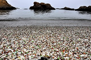
Glass Beach is a beach adjacent to MacKerricher State Park near Fort Bragg, California, that is abundant in sea glass created from years of dumping garbage into an area of coastline near the northern part of the town.

Fort Custer Training Center, often known simply as Fort Custer, is a federally owned and state-operated Michigan Army National Guard training facility, but is also used by other branches of the armed forces and armed forces from Illinois, Indiana, and Ohio. It is one of the most heavily used Midwest training facilities and is used mainly for company level small arms and maintenance training.

Noyo is an unincorporated community in Mendocino County, California. It is located 1 mile (1.6 km) south of the center of Fort Bragg, at an elevation of 108 feet. It is named after the Noyo River, on which it lies; the Noyo River in turn was misnamed by white settlers to the Mendocino area after a village of the Pomo people named Noyo several miles north, on Pudding Creek. The Pomo named the creek after their village, and the settlers transferred the name to the larger river to the south.

Earl Oliver is an American writer, musician, variety, street entertainer, and graphic artist. An accomplished blues and jazz guitarist and singer in Northern California and the San Francisco Bay Area, popularly known as the Walkin' Blues Man, he hosted a popular cable-access television program, "Earl Oliver & Friends: Live from LaVal's", later called "Live on Location", that aired in 16 stations throughout the region from 1992 to 1995. He has also been the lead vocalist for several California-based bands, most recently, the Groovinators.

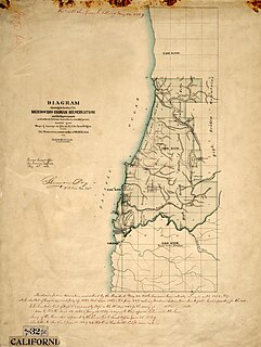
Mendocino Indian Reservation, a former Indian reservation in Mendocino County, one of the early Indian reservations to be established in California by the Federal Government for the resettlement of California Indians. It was established in the spring of 1856, in the vicinity of modern Noyo. Its area was 25,000 acres and its boundary extended north from what is now Simpson Lane at 39°24′43″N123°48′30″W to Abalobadiah Creek and east from the Pacific Ocean to a north–south line passing through the summit of Bald Hill.


