
Bandelier National Monument is a 33,677-acre (13,629 ha) United States National Monument near Los Alamos in Sandoval and Los Alamos counties, New Mexico. The monument preserves the homes and territory of the Ancestral Puebloans of a later era in the Southwest. Most of the pueblo structures date to two eras, dating between 1150 and 1600 AD.

Maquoketa Caves State Park is a state park of Iowa, United States, located in Jackson County. It stands northwest of the city of Maquoketa. In 1991 111 acres (45 ha) on the east side of the park were listed as a historic district on the National Register of Historic Places.

Prince William Forest Park is a national park in the U.S. state of Virginia within Prince William County, located adjacent to the Marine Corps Base Quantico near the town of Dumfries. Established as Chopawamsic Recreational Demonstration Area in 1936, the park is the largest protected natural area in the Washington, D.C. metropolitan region at over 13,000 acres (5,300 ha).

Scenic State Park is a Minnesota state park near Bigfork in Itasca County. It encompasses 3,936 acres (1,593 ha) of virgin pine forests that surround Sandwick Lake and Coon Lake. It also includes portions of Lake of the Isles, Tell Lake, Cedar Lake, and Pine Lake. Established in 1921, the Ojibwe tribe had previously used the area for hunting. The park has places for camping, hiking, swimming, fishing, and canoeing.

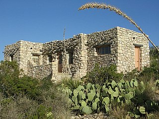
Lincoln National Forest is a unit of the U.S. Forest Service located in southern New Mexico. The Lincoln National Forest covers an extensive 1.1 million acres in southeastern New Mexico. Established by Presidential Proclamation in 1902 as the Lincoln Forest Reserve, the 1,103,897 acres (4,467.31 km2) forest begins near the Texas border and contains lands in parts of Chaves, Eddy, Lincoln, and Otero counties. The Lincoln National Forest is home to three major mountain ranges: Sacramento, Guadalupe and Capitan. The three Ranger Districts within the forest contain all or part of a total of four mountain ranges, and include a variety of different environmental areas, from desert to heavily forested mountains and sub-alpine grasslands. Clean air, water, and soil are necessary elements that the National Forests contribute to the environment. Established to balance conservation, resource management, and recreation, the lands of the Lincoln National Forest include important local timber resources, protected wilderness areas, and popular recreation and winter sports areas. The forest headquarters is located in Alamogordo, N.M. with local offices in Carlsbad, Cloudcroft, and Ruidoso.

The Ozark National Scenic Riverways is a recreational unit of the National Park Service in the Ozarks of southern Missouri in the U.S.

National Park Service rustic – sometimes colloquially called Parkitecture – is a style of architecture that developed in the early and middle 20th century in the United States National Park Service (NPS) through its efforts to create buildings that harmonized with the natural environment. Since its founding in 1916, the NPS sought to design and build visitor facilities without visually interrupting the natural or historic surroundings. The early results were characterized by intensive use of hand labor and a rejection of the regularity and symmetry of the industrial world, reflecting connections with the Arts and Crafts movement and American Picturesque architecture.

The Lummus Park Historic District or simply Lummus Park, is on the National Register of Historic Places and a locally historic designated district in Miami, Florida. It is roughly bound by Northwest Fifth Street to the north, Flagler Street to the south, Northwest Third Avenue to the east, and the Miami River to the west. On October 25, 2006, it was added to the U.S. National Register of Historic Places. Lummus Park has some of the oldest structures in Miami, and over the decades, has been able to retain a large part of its early pioneer character.
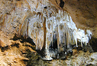
Carlsbad Caverns National Park is an American national park in the Guadalupe Mountains of southeastern New Mexico. The primary attraction of the park is the show cave Carlsbad Cavern. Visitors to the cave can hike in on their own via the natural entrance or take an elevator from the visitor center.

Backbone State Park is Iowa's oldest state park, dedicated in 1919. Located in the valley of the Maquoketa River, it is approximately three miles (5 km) south of Strawberry Point in Delaware County. It is named for a narrow and steep ridge of bedrock carved by a loop of the Maquoketa River originally known as the Devil's Backbone. The initial 1,200 acres (490 ha) were donated by E.M. Carr of Lamont, Iowa. Backbone Lake Dam, a relatively low dam built by the Civilian Conservation Corps (CCC) in the 1930s, created Backbone Lake. The CCC constructed a majority of trails and buildings which make up the park.

Lake of the Ozarks State Park is a Missouri state park on the Grand Glaize Arm of the Lake of the Ozarks and is the largest state park in the state. This is also the most popular state park in Missouri, with over 2.5 million visitations in 2017.

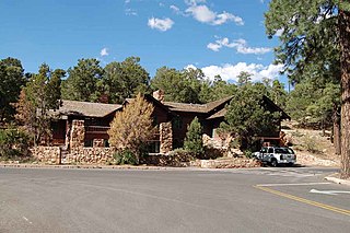
The Jenny Lake Ranger Station Historic District comprises an area that was the main point of visitor contact in Grand Teton National Park from the 1930s to 1960. Located near Jenny Lake, the buildings are a mixture of purpose-built structures and existing buildings that were adapted for use by the National Park Service. The ranger station was built as a cabin by Lee Mangus north of Moose, Wyoming about 1925 and was moved and rebuilt around 1930 for Park Service use. A store was built by a concessioner, and comfort stations were built to Park Service standard plans. All buildings were planned to the prevailing National Park Service Rustic style, although the ranger station and the photo shop were built from parts of buildings located elsewhere in the park.

The Vander Veer Park Historic District is a historic district in Davenport, Iowa, United States, that was listed on the National Register of Historic Places. Over its 70.8-acre (287,000 m2) area, in 1985 it included 66 contributing buildings, two contributing structures, one contributing site, and one contributing object.

The Graves Creek Ranger Station is a small historic district in Olympic National Park, Washington, USA. It includes the first administrative buildings to be built by the National Park Service in the newly designated park. The district comprises two buildings built in 1939-41 by the National Park Service in the Graves Creek region of the western park. Labor from the Civilian Conservation Corps and the Public Works Administration was used for both the ranger station residence and the garage-woodshed, as well as for a generator building that no longer stands. The 1939 ranger station residence is a one-story frame structure, clad in cedar shingles. The garage is of similar construction, built in 1941. Both structures are examples of the late National Park Service Rustic style, featuring broad shingle courses and deep eaves.

The historical buildings and structures of Grand Teton National Park include a variety of buildings and built remains that pre-date the establishment of Grand Teton National Park, together with facilities built by the National Park Service to serve park visitors. Many of these places and structures have been placed on the National Register of Historic Places. The pre-Park Service structures include homestead cabins from the earliest settlement of Jackson Hole, working ranches that once covered the valley floor, and dude ranches or guest ranches that catered to the tourist trade that grew up in the 1920s and 1930s, before the park was expanded to encompass nearly all of Jackson Hole. Many of these were incorporated into the park to serve as Park Service personnel housing, or were razed to restore the landscape to a natural appearance. Others continued to function as inholdings under a life estate in which their former owners could continue to use and occupy the property until their death. Other buildings, built in the mountains after the initial establishment of the park in 1929, or in the valley after the park was expanded in 1950, were built by the Park Service to serve park visitors, frequently employing the National Park Service Rustic style of design.
Architects of the United States Forest Service are credited with the design of many buildings and other structures in National Forests. Some of these are listed on the National Register of Historic Places due to the significance of their architecture. A number of these architectural works are attributed to architectural groups within the Forest Service rather than to any individual architect. Architecture groups or sections were formed within engineering divisions of many of the regional offices of the Forest Service and developed regional styles.
The Caverns Historic District comprises the central developed area of Carlsbad Caverns National Park. The complex was built between the early 1920s and 1942, initially in Pueblo Revival style, and later in New Mexico Territorial Revival style in the area around the natural entrance to Carlsbad Caverns. The earlier structures are built of local limestone, the later buildings in adobe. Thirteen buildings in the district are considered contributing structures. Buildings built between 1940 and 1942 were constructed with labor provided by the Civilian Conservation Corps.
Daniel Ray Hull (1890–1964), sometimes stated Daniel P. Hull, was an American landscape architect who was responsible for much of the early planning of the built environment the national parks of the United States during the 1920s. Hull planned town sites, designed landscapes, and designed individual buildings for the Park Service, in private practice, and later for the California State Parks. A number of his works are listed on the U.S. National Register of Historic Places.
Architects of the National Park Service are the architects and landscape architects who were employed by the National Park Service (NPS) starting in 1918 to design buildings, structures, roads, trails and other features in the United States National Parks. Many of their works are listed on the National Register of Historic Places, and a number have also been designated as National Historic Landmarks.

The Polk County Homestead and Trust Company Addition Historic District is a nationally recognized historic district located in Des Moines, Iowa, United States. It was listed on the National Register of Historic Places in 2016. At the time of its nomination the district consisted of 86 resources, including 48 contributing buildings, 11 contributing structures, 18 non-contributing buildings, and nine non-contributing structures. The end of the 19th-century saw the rise of the Victorian suburbs around Des Moines. This was a period of economic growth for the metropolitan area. The largest of these suburbs was North Des Moines. It was connected to Des Moines by way of three streetcar lines, whiched added to its attractiveness. Local real estate investors established the Polk County Homestead & Trust Co. to develop the northern portion of North Des Moines in partnership with the Prospect Park Improvement Company.


