Reed Bridge

Last updated
Reed Bridge
USA Ohio location map.svg
Red pog.svg
Nearest city Marysville, Ohio
Coordinates 40°08′59″N83°22′50″W / 40.14972°N 83.38056°W / 40.14972; -83.38056 (Reed Covered Bridge) Coordinates: 40°08′59″N83°22′50″W / 40.14972°N 83.38056°W / 40.14972; -83.38056 (Reed Covered Bridge)
Area1 acre (0.40 ha)
Architectural stylePartridge truss
NRHP reference No. 75001547 [1]
Added to NRHPMarch 4, 1975

The Reed Bridge, near Marysville, Ohio, was a Partridge truss covered bridge. It was listed on the National Register of Historic Places in 1975. [1]

It was a single-span wooden bridge which spanned Big Darby Creek. [2]

It was built by Reuben Partridge in 1884 and spanned over 150 feet (46 m). It was the longest covered bridge in Union County. [3]
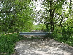
Site of former bridge Reed Covered Bridge site.jpg
Site of former bridge

It was located 3.5 miles south of Marysville off State Route 38 in Darby Township, Union County, Ohio. It was bypassed by Route 38 in the 1960s. The bridge collapsed on August 19, 1993. [3]

Related Research Articles

Bitzers Mill Covered Bridge

The Bitzer's Mill Covered Bridge is a covered bridge that spans the Conestoga River in Lancaster County, Pennsylvania, United States. It is the oldest bridge in the county still in use. A county-owned and maintained bridge, its official designation is the Big Conestoga #2 Bridge. The bridge is also called Martin's Mill Bridge, Eberly's Cider Mill Covered Bridge, and Fiand's/Fiantz's Covered Bridge.

Union County, Ohio County in Ohio, US

Union County is a county located in the U.S. state of Ohio. As of the 2010 census, the population was 52,300. Its county seat is Marysville. Its name is reflective of its origins, it being the union of portions of Franklin, Delaware, Madison, and Logan counties.

Marysville, Ohio City in Ohio, United States

Marysville is a city in and the county seat of Union County, Ohio, United States approximately 27 mi (44 km) NW of Columbus. The population was 22,094 at the 2010 census. This marks a 38.59% increase from 2000.

Elm Grove Stone Arch Bridge United States historic place

The Elm Grove Stone Arch Bridge, also known as the Monument Place Bridge, is the oldest extant bridge, built in 1817, in the U.S. state of West Virginia. The bridge carries U.S. Route 40 over Little Wheeling Creek in Elm Grove. The bridge was placed on the National Register of Historic Places on August 21, 1981.

Parkersburg Bridge (CSX)

The Parkersburg Bridge crosses the Ohio River between Parkersburg, West Virginia, and Belpre, Ohio. Designed by Jacob Linville, the bridge has 46 spans: 25 deck plate girder, 14 deck truss, 6 through truss, and 1 through plate girder. 50,000 cubic yards (38,000 m3) of stone were used for the 53 piers. The bridge was constructed from May 1869 to January 1871 by the Baltimore and Ohio Railroad. At the time of its completion, the bridge was reportedly the longest in the world at 7,140 feet (2,180 m).

Bridgeport Covered Bridge

The Bridgeport Covered Bridge is located in Bridgeport, Nevada County, California, southwest of French Corral and north of Lake Wildwood. It is used as a pedestrian crossing over the South Yuba River. The bridge was built in 1862 by David John Wood. Its lumber came from Plum Valley in Sierra County, California. The bridge was closed to vehicular traffic in 1972 and pedestrian traffic in 2011 due to deferred maintenance and "structural problems".

Bridgeport, Union County, Ohio

Bridgeport is an unincorporated community in far western Darby Township, Union County, Ohio, United States. It lies at the intersection of State Route 38 with Orchard Road, midway between the villages of Milford Center and Unionville Center. At Bridgeport, Buck Run meets the Big Darby Creek, which meets the Scioto River at Circleville. It is located 6 miles (9.7 km) south of Marysville, the county seat of Union County.

Y-Bridge (Zanesville, Ohio) United States historic place

The Zanesville Y-Bridge is a historic Y-shaped three-way bridge that spans the confluence of the Licking and Muskingum Rivers in downtown Zanesville, Ohio. It carries the traffic of U.S. Route 40, as well as Linden Avenue.

Bigelow Bridge

Bigelow Bridge is one of six historic covered bridges in Union County, Ohio. It is located at 40°06′58″N83°25′30″W, on Axe Handle Road just north of Ohio State Route 161 between Irwin and Chuckery, and crosses over the Little Darby Creek.

Harra Covered Bridge United States historic place

The Harra Covered Bridge is a historic wooden covered bridge in Washington County, Ohio, United States. Located in western Watertown Township, about 2 miles (3.2 km) north of the community of Watertown, the bridge spans the South Branch of Wolf Creek near the intersection of State Route 339 and Township Road 172. Among the bridge's more distinctive features are its cut stone abutments, its metal roof, and the vertical siding. Although it has been open for well over one hundred years, it remains in strong structural condition, and it served daily traffic into the late twentieth century.

Hildreth Covered Bridge United States historic place

The Hildreth Covered Bridge, also known as the "Hills Covered Bridge" or "Lafaber's Mill Bridge," is a historic covered bridge in Washington County, Ohio, United States. Located off State Route 26 in Newport Township, about 5 miles (8.0 km) east of the city of Marietta, the bridge historically carried Hills Bridge Road over the Little Muskingum River. Construction of the Hildreth Bridge was a long process: the most significant amount of work was done on the bridge in 1878, but the entire construction process occurred between 1871 and 1881. The identity of its builder is unknown.

Root Covered Bridge United States historic place

The Root Covered Bridge is a historic wooden covered bridge in the southeastern part of the U.S. state of Ohio. Located off State Route 555 in far northern Decatur Township, Washington County, the bridge was built in 1878 in the Long truss mode of truss bridge construction. Measuring 65 feet (20 m) in its single span, it spans the West Branch of the Little Hocking River.

Church Hill Road Covered Bridge United States historic place

The Church Hill Road Covered Bridge is a covered bridge in Columbiana County, Ohio. It was originally located over Middle Fork Little Beaver Creek in Elk Township. The bridge was constructed in 1870 and was relocated in 1982 near the Lock 24 Restaurant on Ohio route 154 east of Lisbon, Ohio.

The Champion Bridge Company, formerly known as Champion Iron Bridge and Manufacturing Company, is a steel fabrication business based in Wilmington, Ohio, in the United States. It has been in business since the 1870s, and several of its works are listed on the National Register of Historic Places.

The historic bridges at the Lancaster campus of Ohio University were moved to the campus and sit about a 100 yards apart. The bridges were built in 1881 and 1884-85 very close to each other, both crossing Poplar Creek, and while the first-built is a wood-and-steel covered bridge and the second-built is all-steel, they are similar in design. Original and current locations of both bridges may be seen in OpenStreetMap linked at right.

Newton Falls Covered Bridge United States historic place

The Newton Falls Covered Bridge, in Newton Falls, Ohio, was built around 1831. It was listed on the National Register of Historic Places in 1974. It is also known as the Arlington Boulevard Covered Bridge.

Kidwell Covered Bridge United States historic place

The Kidwell Covered Bridge, in Dover Township, Athens County, Ohio between the nearby hamlets of Truetown and Redtown, was built in 1880. It spans Sunday Creek. It was listed on the National Register of Historic Places in 1977.

Palos Covered Bridge United States historic place

The Palos Covered Bridge, in Athens County, Ohio near Glouster, was listed on the National Register of Historic Places in 1977. It is a multiple kingpost truss covered bridge.

Rock Mill Covered Bridge United States historic place

The Rock Mill Covered Bridge, on State Route 41 at Rock Mill, Ohio in Bloom Township, Fairfield County, Ohio, is a Queen Post truss bridge. It was listed on the National Register of Historic Places in 1976.

Reuben L. Partridge was an American pioneer and engineer in Union County, Ohio, known locally as "The Bridge Builder".

References

  1. 1 2 "National Register Information System". National Register of Historic Places . National Park Service. November 2, 2013.
  2. Lorrie K. Owen, ed. (1999). "Ohio Historic Places Dictionary, Volume 2". Somerset Publishers, Inc. p. 1364. Retrieved September 7, 2018.
  3. 1 2 "Reed Covered Bridge".