
Brooksville is a town on Penobscot Bay in Hancock County, Maine, United States. As of the 2020 census, the town population was 935. It contains the villages of North Brooksville, South Brooksville, West Brooksville, Brooksville Corner, and Harborside.

The Saint John River is a 673-kilometre-long (418 mi) river that flows from Northern Maine into Canada, and runs south along the western side of New Brunswick, emptying into the Atlantic Ocean in the Bay of Fundy. Eastern Canada's longest river, its drainage basin is one of the largest on the east coast at about 55,000 square kilometres (21,000 sq mi).

Voyageurs National Park is an American national park in northern Minnesota near the city of International Falls established in 1975. The park's name commemorates the voyageurs—French-Canadian fur traders who were the first European settlers to frequently travel through the area. Notable for its outstanding water resources, the park is popular with canoeists, kayakers, other boaters, and fishermen. The Kabetogama Peninsula, which lies entirely within the park and makes up most of its land area, is accessible only by boat. To the east of the park lies the Boundary Waters Canoe Area Wilderness.

West Quoddy Head, in Quoddy Head State Park, Lubec, Maine, is the easternmost point of the contiguous United States. In 1808 a lighthouse was constructed at the site to guide ships through the Quoddy Narrows. The current tower, with distinctive red-and-white stripes, was constructed in 1858 and is an active aid to navigation. The 3rd order Fresnel lens is the only 3rd order and one of only eight Fresnel lenses still in use on the Maine Coast.
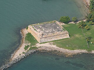
Fortín San Juan de la Cruz, known locally as El Cañuelo, was built on Isla de Cabras in the Palo Seco barrio of the municipality of Toa Baja, at the western end of the entrance to San Juan Bay, in Puerto Rico. The square coastal fort has massive sandstone walls that date back to the 1630s. Although the U.S. Navy bombarded the fort in 1898, the fort survived. Today the fort is part of the San Juan National Historic Site, which is listed as a UNESCO World Heritage Site and on the National Register of Historic Places. The fort is not open to visitors, but it can be viewed from its exterior.

Kent Island is the largest island in the Chesapeake Bay and a historic place in Maryland. To the east, a narrow channel known as the Kent Narrows barely separates the island from the Delmarva Peninsula, and on the other side, the island is separated from Sandy Point, an area near Annapolis, by roughly four miles (6.4 km) of water. At only four miles wide, the main waterway of the bay is at its narrowest at this point and is spanned here by the Chesapeake Bay Bridge. The Chester River runs to the north of the island and empties into the Chesapeake Bay at Kent Island's Love Point. To the south of the island lies Eastern Bay. The United States Census Bureau reports that the island has 31.62 square miles (81.90 km2) of land area.
This is a list of properties on the National Register of Historic Places in the U.S. state of Michigan.
This National Park Service list is complete through NPS recent listings posted August 4, 2023.

The Redington Museum or Redington House is a historic house and museum in Waterville, Maine that is listed on the National Register of Historic Places. The museum is the headquarters of the Waterville Historical Society. Built in 1814, it is one of the best-preserved houses of the period in the city. It has served since 1924 as the museum and headquarters of the Waterville Historical Society, and was listed on the National Register of Historic Places in 1978.

The Fort Point Light, or Fort Point Light Station, is located in Fort Point State Park, in Stockton Springs, Maine. A lighthouse at this point has served as an active aid to navigation since 1835; the present lighthouse dates to 1857, and is listed on the National Register of Historic Places.
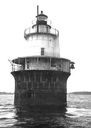
Lubec Channel Light is a sparkplug lighthouse in Lubec, Maine. Established in 1890, it is one of three surviving sparkplug lights in the state, and served as an important aid to navigation on the route from the Bay of Fundy to Eastport, Maine and the St. Croix River It is set in shallow waters in the Lubec Channel, about 500 feet (150 m) from the Canada–United States border. The lighthouse was listed on the National Register of Historic Places as Lubec Channel Light Station on March 14, 1988. The lighthouse was sold by auction into private hands on 2007.
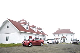
West Quoddy Lifesaving Station is a historic coastal rescue station on West Quoddy Head in Lubec, Maine. The lifesaving station was built in 1919, and was operated by the United States Coast Guard until 1972. It was listed on the National Register of Historic Places on April 20, 1990. It now houses a bed and breakfast inn.

The John Dunlap House, also known as Gilman Mansion, is an historic house located at 4 Oak Street in Brunswick, Maine, United States. Built in 1799, it was probably one of Brunswick's grandest houses of the time, built for John Dunlap, a prominent local businessman. It was listed on the National Register of Historic Places in 1979.

The Newichawannock Canal is a man-made canal which drains Great East Lake into Horn Pond at the border between Wakefield, New Hampshire, and Acton, Maine, in the northeastern United States. It is at the head of the Salmon Falls River, which the Abenaki called Newichawannock, meaning "river with many falls". Begun in 1850 by the Great Falls Company to increase the water available for its mills in Somersworth, New Hampshire, the 0.75-mile (1.21 km) canal is unusual as it was built for strictly industrial purposes in an area remote from the actual industrial site. The canal forms the boundary between the states of New Hampshire and Maine, and is spanned by a stone bridge built at the same time. The canal and bridge, along with related artifacts, were listed on the National Register of Historic Places in 2014.
The Fernald Point Prehistoric Site is an archaeological site in Acadia National Park on Mount Desert Island on the central coast of Maine. The principal feature of the site is a shell midden, whose excavation has yielded both historic artifacts and evidence of human occupation to at least 1000 BCE. The site was listed on the National Register of Historic Places in 1978.

The Gerald Hotel is a former hotel building at 151–157 Main Street in the center of Fairfield, Maine. It was designed by William R. Miller for Amos F. Gerald, one of Maine's leading businessmen of the late 19th century, and built in 1899–1900. It is a striking Renaissance Revival structure, with a sophistication of design and decoration not normally found in rural Maine, and is one of the town's largest buildings. It was listed on the National Register of Historic Places in 2013.

The Auburn–Harpswell Association Historic District encompasses a well-preserved enclave of summer residences built in the early 20th century in southern Harpswell, Maine. The district includes ten Shingle style houses, a Colonial Revival dining hall, and a Greek Revival meeting hall. The Auburn Colony, an exclusive company of businessmen from Auburn, Maine, was responsible for their development. The district was listed on the National Register of Historic Places in 1985.
Ruggles House is a historic house museum at 146 Main Street in Columbia Falls, Maine. Built from 1818 to 1820, in Adamesque style, it is noted for its flying staircase and handcrafted woodwork. The house was listed on the National Register of Historic Places in 1970.

The Great Falls Historic District encompasses the remains of an early 19th-century mill hamlet in Windham, Maine. On the east bank of the Presumpscot River north of Windham Center Road are a cluster of three houses from the period, as well as the archaeological remains of a few mills that lined the river at the falls just north of the road. The district was listed on the National Register of Historic Places in 1995.

The Bartlett Roundhouse, also known as the Bartlett Engine House, is a historic railroad service facility in Bartlett, New Hampshire. Located just south of United States Route 302 and east of Pine Street, it consists of a multibay service building and the remains of a 56-foot (17 m) railroad turntable which provide access to the service bays. Built in 1887–88, it is a reminder of the historic importance of the railroad in the local economy. The site was listed on the National Register of Historic Places in 2015, and the New Hampshire State Register of Historic Places in 2008.

The Chestnut Street Historic District encompasses a predominantly residential part of Camden, Maine, United States, which represents a cross-section of the town's architectural history, and of its transition from a shipping center to a summer resort community. The district extends south from the town common, along Chestnut Street, and then east to Dillingham Point. It was listed on the National Register of Historic Places in 1991.

