
Legion State Park is public recreation area located on the north edge of the city of Louisville, Mississippi, and adjacent to Tombigbee National Forest. As Legion State Park Historic District, the state park entered the National Register of Historic Places in 1998. It is managed by the Mississippi Department of Wildlife, Fisheries and Parks.

Wall Doxey State Park is a public recreation area located off Mississippi Highway 7, seven miles (11 km) south of Holly Springs, Mississippi. The state park is centered on 60-acre (24 ha) Spring Lake.
This is a list of properties and districts in Mississippi that are listed on the National Register of Historic Places. There are more than 1,400 sites distributed among all of Mississippi's 82 counties.
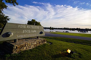
Pere Marquette State Park is an 8,050-acre (3,260 ha) protected area in southwestern Jersey County, Illinois, United States. It is located near the city of Grafton, Illinois, at the confluence of the Mississippi River and the Illinois River. The park is located on Illinois Route 100, which at this location is also part of both the Great River Road and the Meeting of the Great Rivers Scenic Byway. The park is operated and maintained by the Illinois Department of Natural Resources, and is Illinois' largest state park in area. The park is also part of the Confluence Greenway and is at the northwestern end of the 21.5-mile (34.6 km) Sam Vadalabene Bike Trail.

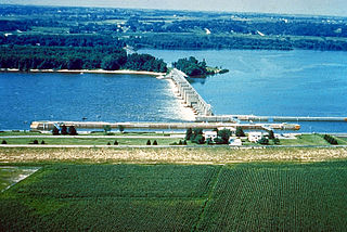
Lock and Dam No. 15 is a lock and dam located on the Upper Mississippi River. It spans the river between Rock Island, Illinois and Davenport, Iowa. Lock and Dam 15 is the largest roller dam in the world, its dam is 1,203 feet (366.7 m) long and consists of nine 109 feet (33.2 m) non-submersible, non-overflow roller gates and two 109 feet (33.2 m) non-submersible overflow roller gates. It is unusual among the upper Mississippi River dams in that it has only roller gates, has different sizes and types of roller gates, it is not perpendicular to the flow of the river and is one of the few facilities that has a completed auxiliary lock. The main lock is 110 feet (33.5 m) wide by 600 feet (180 m) long and its auxiliary lock is 110 feet (34 m) wide by 360 feet (110 m) long. In 2004, the facility was listed in the National Register of Historic Places as Lock and Dam No. 15 Historic District, #04000175 covering 3,590 acres (1,450 ha), 2 buildings, 9 structures, and 1 object.
Lock and Dam No. 16 is a lock and dam located near Muscatine, Iowa on the Upper Mississippi River around river mile 457.2. The movable portion of the dam is 1,315 feet (400.8 m) long and consists of 4 roller gates and 15 Tainter gates. The lock is 110 feet (33.5 m) wide by 600 feet (182.9 m) long with a maximum lift of 9 feet (2.7m) In 2004, the facility was listed in the National Register of Historic Places as Lock and Dam No. 16 Historic District, #04000176 covering 1,024 acres (4.1 km2), 1 building, 5 structures, and 2 objects.

Lock and Dam No. 20 is a lock and dam located on the Upper Mississippi River, the lock side in Canton, Missouri and the dam crossing to Meyer, Illinois.

The Chicago Portage National Historic Site is a National Historic Site commemorating the importance of the Chicago Portage in Lyons, Cook County, Illinois, United States. It is located in Chicago Portage Forest Preserve and the Ottawa Trail Woods Forest Preserve, at the junction of Portage Creek with the Des Plaines River, on the west side of Harlem Avenue on the line of 48th Street. Preserved within the park is the western end of the historic portage linking the Chicago River to the Des Plaines River, thereby linking the Great Lakes to the Mississippi River. A memorial depicting the portage of French explorers is located at the parking area. A trail leads from the memorial down into the portage wilderness area.

The Emerald Mound site, also known as the Selsertown site, is a Plaquemine culture Mississippian period archaeological site located on the Natchez Trace Parkway near Stanton, Mississippi, United States. The site dates from the period between 1200 and 1730 CE. It is the type site for the Emerald Phase of the Natchez Bluffs Plaquemine culture chronology and was still in use by the later historic Natchez people for their main ceremonial center. The platform mound is the second-largest Mississippian period earthwork in the country, after Monk's Mound at Cahokia, Illinois.
Fountainhead is a historic house located at 306 Glenway Drive in Jackson, Mississippi.

Pocahontas is an unincorporated community located in northern Hinds County, Mississippi on U.S. Route 49. It is located 5 miles (8.0 km) south of Flora and 9 miles (14 km) north of Jackson and part of the Jackson Metropolitan Statistical Area. Pocahontas has a ZIP code 39072.

The C.H. Nash Museum at Chucalissa is located on and exhibits excavated materials of the Mississippian culture archaeological site known as Chucalissa which means "abandoned house" in Chickasaw. The site is located adjacent to the T. O. Fuller State Park within the city of Memphis, Tennessee, United States. Chucalissa was designated National Historic Landmark in 1994 due to its importance as one of the best-preserved and major prehistoric settlement sites in the region.

The Murphy Mound Archeological Site, is a prehistoric archaeological site in the Bootheel region of the U.S. state of Missouri. Located southwest of Caruthersville in Pemiscot County, Missouri the site was occupied by peoples of the Late Mississippian period, centuries before European colonization of the area.
Seven segments of the historic Natchez Trace are listed on the National Register of Historic Places (NRHP). Also there are additional NRHP-listed structures and other sites along the Natchez Trace, which served the travelers of the trace and survive from the era of its active use.

The Adams site (15FU4) is a Mississippian culture archaeological site located near Hickman in Fulton County, Kentucky, on Bayou de Chien, a creek that drains into the nearby Mississippi River.

The George Tromley Jr. House is a historic building located in Le Claire, Iowa, United States. It has been listed on the National Register of Historic Places since 1979. The property is part of the Houses of Mississippi River Men Thematic Resource, which covers the homes of men from LeClaire who worked on the Mississippi River as riverboat captains, pilots, builders and owners.

Foster's Mound is a Plaquemine culture archaeological site located in Adams County, Mississippi northeast of Natchez off US 61. It is the type site for the Foster Phase of the Natchez Bluffs Plaquemine culture chronology. It was added to the NRHP on September 2, 1982 as NRIS number 82003091. The mounds are listed on the Mississippi Mound Trail.

This is a list of the National Register of Historic Places listings in Mississippi County, Missouri.

The Golden Eagle-Toppmeyer Site is a pre-Columbian archaeological site located near the confluence of the Illinois and Mississippi Rivers in Calhoun County, Illinois. The site is associated with the Havana Hopewell culture and has two main components: the Golden Eagle earthwork and the Toppmeyer habitation site. The earthwork, which dates from the Middle Woodland period, is the only geometric earthwork from the period in the central Mississippi River valley. Two mounds are incorporated in the rounded earthwork; one is located at the center, and one is located at a gap which has been called the "entrance" to the earthwork. The Toppmeyer habitation site, which overlaps the western edge of the earthwork, dates from the Late Woodland period. The overall site was likely a regional transaction center at which extensive trade and cultural exchange among Hopewell people in the Illinois River valley took place.
The Four Mounds site is a historic site located in Dubuque, Iowa, United States. It is made up of a row of four conical burial mounds on a blufftop that overlooks the Mississippi River. They are prehistoric in their origin. The site was individually listed on the National Register of Historic Places in 2000. It was included as a contributing property in the Four Mounds Estate Historic District in 2002.

