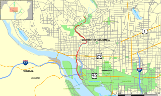
The Rock Creek and Potomac Parkway, often known simply as the Rock Creek Parkway, is a parkway maintained by the National Park Service as part of Rock Creek Park in Washington, D.C. It runs next to the Potomac River and Rock Creek in a generally north–south direction, carrying four lanes of traffic from the Lincoln Memorial and Arlington Memorial Bridge north to a junction with Beach Drive near Connecticut Avenue at Calvert Street, N.W., just south of the National Zoological Park.
Gore Pass is a high mountain pass in the Rocky Mountains of northwestern Colorado in the United States.

This is a directory of properties and districts listed on the National Register of Historic Places in Wyoming. There are more than 500 listed sites in Wyoming. Each of the 23 counties in Wyoming has at least four listings on the National Register.

There are more than 1,500 properties and historic districts in Colorado listed on the National Register of Historic Places. They are distributed over 63 of Colorado's 64 counties; only Broomfield County has none.
These historic properties and districts in the state of Texas are listed in the National Register of Historic Places. Properties and/or districts are listed in most of Texas's 254 counties.

North Creek is a census-designated place and hamlet in the Adirondack Park, in the town of Johnsburg, in Warren County, New York, United States. It is an area known for skiing, hiking and other outdoor recreational activities. It is located at 43°41′52″N73°59′11″W.

Toponas is an unincorporated rural village in Routt County, Colorado, United States. The community took its name from nearby Toponas Rock. The population in 2010 was 48; in 2017 it is estimated at 26, all in ages ranging from 55 years upwards.

The Hole in the Rock Trail is a historic trail running east-southeast from the town of Escalante in southern Utah in the western United States. The Mormon trailblazers who established this trail crossed the Colorado River and ended their journey in the town of Bluff. The Hole-in-the-Rock expedition established the trail in 1879. The trail is located within the borders of the Grand Staircase-Escalante National Monument, the adjacent Glen Canyon National Recreation Area and federal Bureau of Land Management (BLM) public land to the east of the Colorado River. A geologic feature called the Hole in the Rock gave the trail its name. A modern unpaved road called the Hole-in-the-Rock Road closely follows this historic trail to the point where it enters the Glen Canyon National Recreation Area. The modern road is an important access route for visiting the Canyons of the Escalante and the Devils Garden. The trail is listed on the National Register of Historic Places, being added to that list in 1982.

State Highway 134 (SH 134) is a 27.163 mi (43.715 km) long state highway in northern Colorado. SH 134's western terminus is at SH 131 in Toponas, and the eastern terminus is at U.S. Route 40 north of Kremmling.

Rock Creek Station and Stricker Homesite is a historical site operated by the Idaho State Historical Society. It includes the Stricker Store and Farm, which was listed on the National Register of Historic Places in 1979. Two previously important roadways met at this site.

The Timber Creek Campground Comfort Stations are a set of three historic public toilet facilities in Rocky Mountain National Park. Designed in 1935 by landscape architect Howard W. Baker of the National Park Service Branch of Plans and Designs, the National Park Service Rustic buildings were built with Civilian Conservation Corps labor in 1939. They were added to the National Register of Historic Places on January 29, 1988.

The Grand Ditch, also known as the Grand River Ditch and originally known as the North Grand River Ditch, is a water diversion project in the Never Summer Mountains, in northern Colorado. It is 14.3 miles (23.0 km) long, 20 feet (6.1 m) wide, and 3 feet (0.91 m) deep on average. Streams and creeks that flow from the highest peaks of the Never Summer Mountains are diverted into the ditch, which flows over the Continental Divide at La Poudre Pass at 10,175 feet (3,101 m), delivering the water into Long Draw Reservoir and the Cache La Poudre River for eastern plains farmers. The ditch was started in 1890 and wasn't completed until 1936. The ditch diverts between 20 and 40% of the runoff from the Never Summer Mountains, and delivers an average of 20,000 acre feet (25,000,000 m3). It significantly impacts the ecology in the valley below and the National Park Service has fought in court to reduce the amount of diverted water.
Durango Rock Shelters Archeology Site is also known as the Fall Creek Rock Shelters Site. An Ancient Pueblo People (Anasazi) archaeological site, it is located in Durango in La Plata County, Colorado. People from the Late Basketmaker II and Basketmaker III Eras inhabited the site between AD 1 and 1000.

Gulf, Colorado and Santa Fe Railroad Passenger Station is located on 1501 Jones Street in Fort Worth, Texas. The depot was built by the Gulf, Colorado and Santa Fe Railroad in 1900 and renovated in 1938. It was originally called the Fort Worth Union Depot. Other tenant railroads at the station were the Chicago, Rock Island and Gulf Railway, the St. Louis–San Francisco Railway ('Frisco') and the Southern Pacific Railroad.
Architects of the National Park Service are the architects and landscape architects who were employed by the National Park Service (NPS) starting in 1918 to design buildings, structures, roads, trails and other features in the United States National Parks. Many of their works are listed on the National Register of Historic Places, and a number have also been designated as National Historic Landmarks.

The Cold Springs Station Site, west of Austin, Nevada, is a historic stagecoach station site that was active during 1861-1869 as a passenger and freight station, and later for freight. Only stone ruins remain. Nearby is the location of the original Cold Springs Pony Express Station Ruins.

The Point of Rocks Stage Station is a former resting place at the meeting point of the Overland Trail and the Union Pacific Railroad in Sweetwater County, Wyoming, USA. It was built as a stop for the Overland Stage Line in the 1861 or 1862, equidistant between the earlier Black Buttes and Salt Wells stations, which were 28 miles (45 km) apart. The station served the stage line from 1862 to 1868. In 1868, the Union Pacific line reached Point of Rocks, putting the stage line out of business. The station then became a freight depot for nearby mines, with a road leading to Atlantic City and South Pass. The freight activity declined, and in 1877, the station became a residence. At one point it was allegedly inhabited by Jim McKee, a former member of the Hole in the Wall Gang. It became the property of the state of Wyoming in 1947 and is administered as Point of Rocks Stage Station State Historic Site.
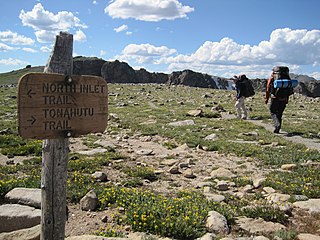
The Tonahutu Creek Trail, in the general area of Grand Lake, Colorado, in both Grand and Larimer counties, was listed on the National Register of Historic Places in 2008.
