
Rock Creek Park is a large urban park that bisects the Northwest quadrant of Washington, D.C. Created by Act of Congress in 1890, the park comprises 1,754 acres, generally along Rock Creek, a tributary of the Potomac River.
The Rock Creek and Potomac Parkway, informally called the Rock Creek Parkway, is a parkway maintained by the National Park Service as part of Rock Creek Park in Washington, D.C. It runs next to the Potomac River and Rock Creek in a generally north–south direction, carrying four lanes of traffic from the Lincoln Memorial and Arlington Memorial Bridge north to a junction with Beach Drive near Connecticut Avenue at Calvert Street, N.W., just south of the National Zoological Park. During rush hours, the parkway is converted to one-way traffic corresponding to the peak direction of travel: southbound in the morning and northbound in the afternoon.
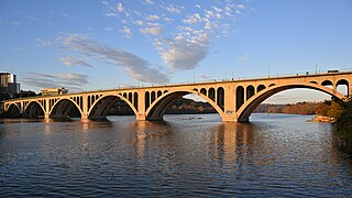
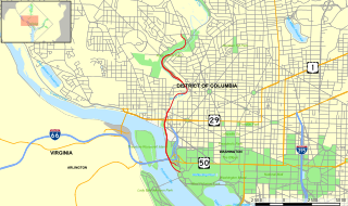
The Francis Scott Key Bridge, more commonly known as the Key Bridge, is a six-lane reinforced concrete arch bridge carrying U.S. Route 29 (US 29) across the Potomac River between the Rosslyn neighborhood of Arlington County, Virginia, and the Georgetown neighborhood of Washington, D.C. Completed in 1923, it is Washington's oldest surviving road bridge across the Potomac River.

Connecticut Avenue is a major thoroughfare in the Northwest quadrant of Washington, D.C., and suburban Montgomery County, Maryland. It is one of the diagonal avenues radiating from the White House, and the segment south of Florida Avenue was one of the original streets in Pierre (Peter) Charles L'Enfant's plan for Washington. A five-mile segment north of Rock Creek was built in the 1890s by a real-estate developer.

The Taft Bridge is a historic bridge located in the Northwest quadrant of Washington, D.C. It carries Connecticut Avenue over the Rock Creek gorge, including Rock Creek and the Rock Creek and Potomac Parkway, connecting the neighborhoods of Woodley Park and Kalorama. It is named after former United States president and Supreme Court Chief Justice William Howard Taft, and sits to the southwest of the Duke Ellington Bridge.

The Dumbarton Bridge, also known as the Q Street Bridge and the Buffalo Bridge, is a historic masonry arch bridge in Washington, D.C.
This is a list of properties and districts in Washington, D.C., on the National Register of Historic Places. There are more than 600 listings, including 74 National Historic Landmarks of the United States and another 13 places otherwise designated as historic sites of national importance by Congress or the President.

Buildings, sites, districts, and objects in Virginia listed on the National Register of Historic Places:

Ohio Drive is a street in Southwest Washington, D.C., located in East and West Potomac Parks and bordering the Tidal Basin, Washington Channel, and the Potomac River. It is a central organizing feature of East Potomac Park, providing the only major vehicular route to and through the area. Unlike most roadways named after states in the District of Columbia, Ohio Drive is not an avenue, nor it is heavily used like Wisconsin or Rhode Island Avenues. However, the segment from Independence Avenue to the Rock Creek and Potomac Parkway is an important commuter route.

Sheridan Circle is a traffic circle and park in the Sheridan-Kalorama neighborhood of Washington, D.C. The traffic circle, one of two in the neighborhood, is the intersection of 23rd Street NW, Massachusetts Avenue NW, and R Street NW. The buildings along this stretch of Massachusetts Avenue NW are part of Embassy Row, which runs from Scott Circle to Observatory Circle. Sheridan Circle is a contributing property to the Massachusetts Avenue Historic District and the Sheridan-Kalorama Historic District, both listed on the National Register of Historic Places (NRHP). In addition, the equestrian statue of General Philip Sheridan is 1 of 18 Civil War Monuments in Washington, D.C., that were collectively listed on the NRHP.

The Embassy Gulf Service Station is a service station in Washington, D.C., located on P Street near Dupont Circle and at the entrance to the Georgetown neighborhood. Constructed in 1937, it was added to the National Register of Historic Places in 1993.

The Boulder Bridge is a historic bridge located in the Washington, D.C. portion of Rock Creek Park, an urban national park listed on the National Register of Historic Places.

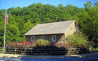
The Old Stone House is one of the oldest structures in Washington, D.C. The house is also the last pre-revolutionary colonial building in Washington, D.C. Built in 1765, Old Stone House is located at 3051 M Street, Northwest in the city's Georgetown neighborhood. Sentimental local folklore preserved the Old Stone House from being demolished, unlike many colonial homes in the area that were replaced by redevelopment.

The Embassy of Uzbekistan in Washington, D.C.,, is the diplomatic mission of the Republic of Uzbekistan to the United States. The current Ambassador of Uzbekistan to the United States is Furqat Sidikov. The embassy is located at 1746 Massachusetts Avenue NW on Embassy Row in Washington, D.C., between Scott Circle and Dupont Circle. Constructed in 1909, the Clarence Moore House is an example of Beaux Arts architecture in blond Roman brick with limestone dressings; it was used by the Canadian government until the 1980s. The house was listed on the National Register of Historic Places (NRHP) on April 3, 1973. The building is also designated a contributing property to the Massachusetts Avenue Historic District and Dupont Circle Historic District, which are both listed on the NRHP.

The Klingle Valley Bridge, officially known as the Connecticut Avenue Bridge, is an Art Deco steel-arch bridge located near the National Zoological Park on Connecticut Avenue, Northwest in Washington, D.C. The bridge crosses Klingle Valley, running from Macomb Street to Devonshire Place and connecting the Cleveland Park and Woodley Park neighborhoods.

The Oak Hill Cemetery Chapel, also known as the Renwick Chapel or James Renwick Chapel, is a historic building in the Georgetown neighborhood of Washington, D.C., United States. Designed by James Renwick Jr. in 1850, Oak Hill Cemetery Chapel is the architect's only known example of Gothic Revival church architecture in Washington, D.C. It is located on the highest ridge in Oak Hill Cemetery, near the intersection of 29th and R Streets NW. The chapel is one of two structures in Oak Hill Cemetery listed on the National Register of Historic Places, the other being the Van Ness Mausoleum. The chapel, mausoleum, and cemetery are contributing properties to the Georgetown Historic District, a National Historic Landmark.

The following outline is provided as an overview of and topical guide to the District of Columbia:
Piney Branch is a tributary of Rock Creek in Washington, D.C. It is the largest tributary located entirely within the Washington city limits. It is spanned by the 16th Street Bridge, the country's first parabolic arch bridge.

The Kalorama Triangle Historic District is a mostly residential neighborhood and a historic district in the northwest quadrant of Washington, D.C. The entire Kalorama Triangle neighborhood was listed on the District of Columbia Inventory of Historic Sites (DCIHS) and National Register of Historic Places (NRHP) in 1987. In addition to individually listed landmarks in the neighborhood, the district is home to roughly 350 contributing properties. The neighborhood is roughly bounded by Connecticut Avenue to the west, Columbia Road to the east, and Calvert Street on the north.


