Rushseba Township, Chisago County, Minnesota

Last updated

Rushseba Township
USA Minnesota location map.svg
Red pog.svg
Rushseba Township
Location within the state of Minnesota
Coordinates: 45°41′18″N92°55′55″W / 45.68833°N 92.93194°W / 45.68833; -92.93194
Country United States
State Minnesota
County Chisago
Area
  Total30.4 sq mi (78.7 km2)
  Land30.0 sq mi (77.6 km2)
  Water0.4 sq mi (1.1 km2)
Elevation
902 ft (275 m)
Population
 (2010)
  Total804
  Density27/sq mi (10.4/km2)
Time zone UTC-6 (Central (CST))
  Summer (DST) UTC-5 (CDT)
ZIP code
55069 [1]
Area code 320
FIPS code 27-56392 [2]
GNIS feature ID0665491 [3]

Rushseba Township is a township in Chisago County, Minnesota, United States. The population was 804 at the 2010 census. [4]

Contents

History

Rushseba Township was organized in 1858. The county was named from the Rush River, and -seba, an Ojibwe language word meaning "river". [5]

Geography

Rushseba Township is located in the northeast corner of Chisago County, bordered to the east by the St. Croix River and the state of Wisconsin. To the north is the city of Rock Creek in Pine County, to the west is Nessel Township, and to the south are the city of Harris and Sunrise Township. The city of Rush City is in the western part of the township but is administratively separate.

Interstate 35 follows the western boundary line of the township, leading north to Rock Creek and Pine City, and south to Harris and North Branch. The closest access is from County 1 exit in Rush City.

According to the United States Census Bureau, Rushseba Township has a total area of 30.4 square miles (78.7 km2), of which 30.0 square miles (77.6 km2) is land and 0.42 square miles (1.1 km2), or 1.34%, is water. [4]

Demographics

Historical population
CensusPop.Note
1860 179
1870 706294.4%
1880 394−44.2%
1890 52934.3%
1900 77346.1%
1910 658−14.9%
1920 79220.4%
1930 738−6.8%
1940 727−1.5%
1950 632−13.1%
1960 6523.2%
1970 72210.7%
1980 7321.4%
1990 715−2.3%
2000 7697.6%
2010 8044.6%
U.S. Decennial Census [6]

As of the census [2] of 2000, there were 769 people, 274 households, and 226 families residing in the township. The population density was 25.0 people per square mile (9.6/km2). There were 313 housing units at an average density of 10.2/sq mi (3.9/km2). The racial makeup of the township was 97.92% White, 0.52% Native American, 0.39% Asian, 0.26% from other races, and 0.91% from two or more races. Hispanic or Latino of any race were 0.78% of the population.

There were 274 households, out of which 36.1% had children under the age of 18 living with them, 71.9% were married couples living together, 5.5% had a female householder with no husband present, and 17.2% were non-families. 12.8% of all households were made up of individuals, and 6.2% had someone living alone who was 65 years of age or older. The average household size was 2.81 and the average family size was 3.07.

In the township the population was spread out, with 27.6% under the age of 18, 5.6% from 18 to 24, 29.8% from 25 to 44, 26.8% from 45 to 64, and 10.3% who were 65 years of age or older. The median age was 38 years. For every 100 females, there were 102.9 males. For every 100 females age 18 and over, there were 111.0 males.

The median income for a household in the township was $47,917, and the median family income was $50,938. Males had a median income of $38,542 versus $24,063 for females. The per capita income for the township was $19,727. About 3.4% of families and 5.6% of the population were below the poverty line, including 5.2% of those under age 18 and 13.6% of those over 64.

Related Research Articles

Eckles Township is a township in Beltrami County, Minnesota, United States. The population was 1,516 as of the 2010 census.

Twin Lakes Township is a township in Carlton County, Minnesota, United States. The population was 1,912 as of the 2000 census.

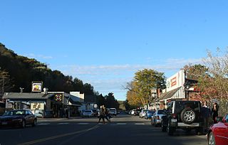
Amador Township is a township in Chisago County, Minnesota, United States. The population was 885 at the 2010 census. The unincorporated community of Almelund is located within the township.

<span class="mw-page-title-main">Chisago City, Minnesota</span> City in Minnesota, United States

Chisago City is a city in Chisago County, Minnesota, United States, approximately 35 miles northeast of downtown Minneapolis–Saint Paul. The population was 4,967 at the 2010 census.

Chisago Lake Township is a township in Chisago County, Minnesota, United States. The population was 4,656 at the 2010 census, up from 3,276 in 2000.

Fish Lake Township is a township in Chisago County, Minnesota, United States. The population was 2,012 at the 2010 census.

<span class="mw-page-title-main">Franconia Township, Chisago County, Minnesota</span> Township in Minnesota, United States

Franconia Township is a township in Chisago County, Minnesota, United States. The population was 1,805 at the 2010 census, up from 1,128 in 2000. The township is home to the Franconia Sculpture Park.

<span class="mw-page-title-main">Harris, Minnesota</span> City in Minnesota, United States

Harris is a city in Chisago County, Minnesota, United States. The population was 1,132 at the 2010 census. There is a restaurant, a post office, a bar and grill, and tattoo shop, among other businesses. Interstate 35 serves as a main route for the community.

Lent Township is a former township in Chisago County, Minnesota, United States. The population was 3,091 as of the 2010 census, up from 1,992 in 2000.

Nessel Township is a township in Chisago County, Minnesota, United States. The population was 1,951 at the 2010 census.

<span class="mw-page-title-main">North Branch, Minnesota</span> City in Minnesota, United States

North Branch is a city in Chisago County, Minnesota, United States, at the junction of Interstate 35 and Minnesota State Highway 95. The population was 10,787 at the 2020 census. It is named for the north branch of the Sunrise River, which flows through the city.

<span class="mw-page-title-main">Rush City, Minnesota</span> City in Minnesota, United States

Rush City is a city in Chisago County, Minnesota, United States. The population was 3,079 at the 2010 census. It is fifty-eight miles north of Minneapolis–Saint Paul.

Shafer Township is a township in Chisago County, Minnesota, United States. The population was 1,048 as of the 2010 census, up from 646 in 2000.

Sunrise Township is a township in Chisago County, Minnesota, United States. The population was 1,994 at the 2010 census, up from 1,594 in 2000.

<span class="mw-page-title-main">Taylors Falls, Minnesota</span> City in Minnesota, United States

Taylors Falls is a city in Chisago County, Minnesota, United States, located at the junction of U.S. Highway 8 and Minnesota State Highway 95. The population was 1,055 at the 2020 census.

<span class="mw-page-title-main">Wyoming, Minnesota</span> City in Minnesota, United States

Wyoming is a city in Chisago County, Minnesota. The population was 7,791 at the time of the 2010 census.

Wyoming Township is a former township in Chisago County, Minnesota, United States. The population was 4,379 at the 2000 census.

Holt Township is a township in Fillmore County, Minnesota, United States. The population was 307 at the 2000 census.

Krain Township is a township in Stearns County, Minnesota, United States. The population was 981 at the 2010 census. The township includes the city of St. Anthony.

<span class="mw-page-title-main">Center City, Minnesota</span> City in Minnesota, United States

Center City is a city and the county seat of Chisago County, Minnesota, United States. The population was 628 at the 2010 census.

References

  1. "Rushseba Township MN ZIP Code". zipdatamaps.com. 2024. Retrieved February 5, 2024.
  2. 1 2 "U.S. Census website". United States Census Bureau . Retrieved January 31, 2008.
  3. "US Board on Geographic Names". United States Geological Survey. October 25, 2007. Retrieved January 31, 2008.
  4. 1 2 "Geographic Identifiers: 2010 Demographic Profile Data (G001): Rushseba township, Chisago County, Minnesota". U.S. Census Bureau, American Factfinder. Archived from the original on February 12, 2020. Retrieved October 2, 2014.
  5. Upham, Warren (1920). Minnesota Geographic Names: Their Origin and Historic Significance. Minnesota Historical Society. p.  109.
  6. "Census of Population and Housing". Census.gov. Retrieved May 26, 2019.