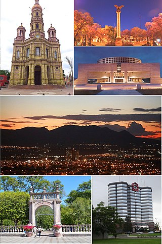
Aguascalientes is the capital of the Mexican state of the same name and its most populous city, as well as the head of the Aguascalientes Municipality; with a population of 934,424 inhabitants in 2012 and 1,225,432 in the metro area. The metropolitan area also includes the municipalities of Jesús María and San Francisco de los Romo. It is located in North-Central Mexico, which roughly corresponds to the Bajío region (Lowlands) within the central Mexican plateau. The city stands on a valley of steppe climate at 1880 meters above sea level, at 21°51′N102°18′W.

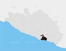
Aguascalientes, officially the Free and Sovereign State of Aguascalientes, is one of the 32 states which comprise the Federal Entities of Mexico. At 22°N and with an average altitude of 1,950 m (6,400 ft) above sea level it is predominantly of semi-arid climate. The state is located in west-central Mexico and is located in the northern part of the Bajío region, which is in the north-central part of the country, bordered by Zacatecas to the north, east and west, and by Jalisco to the south.

The Nueva Esparta State is one of the 23 states of Venezuela. It comprises Margarita Island, Coche, and the largely uninhabited Cubagua.

Táchira State is one of the 23 states of Venezuela. The state capital is San Cristóbal.

San Cristóbal is the capital city of the Venezuelan state of Táchira. It is located in a mountainous region of Western Venezuela. The city is situated 818 metres (2,684 ft) above sea level in the northern Andes overlooking the Torbes River, 56 kilometres (35 mi) from the Colombian border. San Cristóbal was founded on March 31, 1561, by Juan de Maldonado. From its inception, the city evolved rapidly as one of the most progressive and important centers of commerce in the country and the region, due primarily to its rich soil and its proximity to the border with Colombia.

Tlaquepaque, officially San Pedro Tlaquepaque, is a city and the surrounding municipality in the Mexican state of Jalisco.

Ahuachapán is a city, and municipality, and the capital of the Ahuachapán Department in western El Salvador. The municipality, including the city, covers an area of 244.84 km² and as of 2007 has a population of 110,511 people. Situated near the Guatemalan border, it is the westernmost city in the country and is the center of an agricultural region producing primarily coffee.

Soyapango is a municipality in the San Salvador department of El Salvador. Soyapango is a commercial center. The municipality is the third most populated area in the country, with 290,412 inhabitants. Soyapango is a satellite city of San Salvador and it is the main thoroughfare between San Salvador and the eastern part of the country, and nearly 70,000 vehicles travel through it every day. The nickname for this satellite city is Soya.

Jalostotitlán is a town and municipality located in the northeast corner of the state of Jalisco, Mexico, in a region known as Los Altos.

Arganda del Rey is a municipality and city of Spain located in the Community of Madrid.

San Nicolás Tolentino is a municipality and town located in the Mexican state of San Luis Potosí, Mexico. The municipality was founded in 1614, and consists of many small towns and villages. Santa Catarina is the largest town in the municipality. In 1827, the Municipal Presidency was established in the town.

Las Margaritas is a city, and the surrounding municipality of the same name, in the Mexican state of Chiapas. The municipal seat is located some 25 km to the northeast of Comitán de Domínguez, while the municipality extends to the east as far as the border with Guatemala. Part of the Lagunas de Montebello National Park is in the municipality's territory.

El Bosque, Chiapas is a town and municipality in the Mexican state of Chiapas in southern Mexico. It covers an area of 241 km2 (93 sq mi).

Sabanilla is a town and municipality in the Mexican state of Chiapas in southern Mexico.
El Carmen, often known as "Carmen", is a town and municipality of the northeastern Mexican state of Nuevo León. The population was 6,996 at the 2005 census. Located in the Salinas Valley region, it is one of the smallest municipalities of the state of Nuevo León, is bordered by the municipalities of Salinas Victoria at North and East, General Escobedo at South, Abasolo and Hidalgo at West. As of 2009, its population is projected to be much higher than it was in the last census, as there is a large number of people moving to this municipality and surrounded municipalities, mainly people from other places outside Nuevo León, because of the lower house prices, compared to that of Monterrey, and the increasing potential of the region due to the relatively close distance to Monterrey, and constant expansion of its metropolitan area, which is estimated to absorb this municipality soon.
Tonaya is a town and municipality, in Jalisco in central-western Mexico. The municipality covers an area of 293.6 km2.

Tezonapa is a municipality located in the high mountain region in the Mexican state of Veracruz, about 219 km from the state capital Xalapa. It covers an area of 351 square kilometres (136 sq mi). The law number 93 of December 22, 1960 San Agustín created Tezonapa's municipality with the congregations of the Josefinas, Prison, Tezonapa, Palmarito, etc.

San Juan de Cinco Pinos, colloquially known as Cinco Pinos, is a town and a municipality in the north of the Chinandega Department in Nicaragua, situated between San Pedro del Norte and Santo Tomás del Norte.
Otumba is a municipality in the State of Mexico in Mexico. The municipal seat and largest town is Otumba de Gómez Farías. The municipality of Otumba has a land area of some 143.42 square kilometres (55 sq mi), and a population recorded in the intermedial 2005 census, the Conteo de Población y Vivienda, of 29,873.
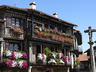
La Alberca is a municipality in the province of Salamanca in the autonomous community of Castilla y León, Spain. It is the capital of Sierra de Francia Comarca.