Sargent, Texas | |
---|---|
Coordinates: 28°50′06″N95°39′53″W / 28.83500°N 95.66472°W | |
Country | United States |
State | Texas |
Counties | Matagorda |
Settled | 1834 |
Named for | George Thomas Sargent [1] |
Elevation | 3 ft (0.9 m) |
Population (2015 [3] ) | |
• Total | 2,764 |
Time zone | UTC-6 (CST) |
• Summer (DST) | UTC-5 (CDT) |
ZIP code | 77414 |
Area code | 979 |
FIPS code | 48321 |
GNIS feature ID | 2805811 [2] |
Farm Roads |
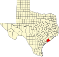
Sargent is a small unincorporated community located in the eastern corner of Matagorda County, Texas, United States.
Sargent is a fishing, boating, and water sports community with a variable population, as most of its inhabitants are weekend commuters from larger cities such as Houston, Austin, and San Antonio. Sargent is on Farm to Market Road 457, five miles northwest of the Gulf of Mexico and twenty-four miles southeast of Bay City, in the eastern corner of Matagorda County. Approximately 501 permanent residents live in the Sargent area, while on holiday weekends the population may swell to as high as 5,000. The Sargent area, with its proximity to the Gulf of Mexico, East Matagorda Bay, the Intracoastal Waterway, and Caney Creek, is home base to many commercial and sport fisherman and shrimpers. Red drum (aka Redfish), Spotted Seatrout (aka Speckled Trout), Flounder, Blue Crab and shrimp are among the local favorites.
In addition to the local fishing, one of the unique appeals of Sargent is that many of the homesites are waterfront. Several developments, such as Caney Creek Estates, became established in the late 1950s and early 1960s. Following the widespread damage caused by Hurricane Carla in 1961, other developments such as Downey's Caney Creek, Caney Court, and Caney Creek Haven were established, including new waterfront lots created by the digging of manmade canals off Caney Creek and the Intracoastal Waterway.
Many waterfront lots were originally sold as campsites. Much of Sargent still has a fishing camp influence with many recreational vehicles present, although the majority of developed homesites now have permanent dwellings. Also prevalent are the many private wooden piers and docks, where modern recreational watercraft can be docked. Most piers also have electric fishing lights that allow night fishing, particularly during the colder months where Spotted Seatrout are known to feed as they migrate inland. [4]
Sargent Beach, where multiple rows of beach houses in the 1960s eventually succumbed to continual coastal erosion, has received more attention to preserve what remains of this relatively narrow island bordered by the Gulf of Mexico, the Intracoastal Waterway, Mitchell's Cut into East Matagorda Bay, and the San Bernard River far to the east.
Sargent was named for George Thomas Sargent. [1] Sargent and his family relocated to Texas from England in 1834, and established a permanent residence in Matagorda County in 1838, quickly becoming a major land owner in the area. Sargent and his daughter-in-law, Sarah Ann, drowned in a hurricane in 1875. They are buried in a small family cemetery located in Caney Creek Estates and maintained by local residents. The site was awarded a historical marker by the Texas Historical Commission in 1986. [5]
Mitchell's Cut is basically the continuation of Caney Creek. Caney Creek is almost long enough to be a river and has often had brackish water, even a few miles inland. The "Pass" runs into the gulf and is 1/4 mile down the cut, past the entrance to East Matagorda Bay. The "cut" is a favorite fishing site for families, and anglers. Many favorite local boat park onshore, anchor and wade in various fishing spots are in this area, such as "Leroy's Hole." Occasionally, an incoming blue ocean current will run into the 50-foot-wide (15 m) pass at the beach-front for excellent fishing.
The cut also allows boat passage to the gulf for offshore fishing and shrimping, and is vital to the live bait and shrimp sales for the community. The "Cut" (known as the Caney Creek Gulf Cut, or Mitchell's Cut) is the only pass from Freeport to Matagorda and has obvious importance to East Matagorda Bay, Sargent, and the people who live in the general area. The shore line between Sargent's pass is a stretch of land between the gulf and East Matagorda Bay and part of the Matagorda Peninsula. The pass allows for drainage of water from Caney Creek past the Intracoastal Waterway, into the gulf or East Matagorda Bay, especially in times of large rainfall in the drainage basins adjacent to Caney Creek. There are a multitude of shifting tides, water depth, and new sandbars throughout the year. A common problem is a sand bar that runs across the cut about 100 yards out and affects the bigger shrimp boats on a low tide.
The most notable effort to protect Sargent Beach was obtaining funding for and completing development of a granite breakwater revetment designed and installed by the U.S. Army Corps of Engineers in the early 1990s. This substructure is designed to help prevent coastal erosion and protect inland homes from storm surge in the event of a tropical cyclone making landfall near the area. [6]
In 2013, Coastal Technology Corporation from Austin, Texas, in conjunction with the Conrad Blucher Institute of Texas A&M University-Corpus Christi, received two grants totalling $340,000 from the Port of Bay City Authority to study improving the pass. [7]
In early 2017, construction began on a pier built with concrete pilings extending into the Gulf at Sargent Beach. The pier project, first proposed in 2013, was funded by the federal Coastal Impact Assistance Program (CIAP) and administered by the U.S. Fish and Wildlife Service. The structure was originally designed to be a 10-foot wide pier, extending approximately 500 feet into the Gulf, terminating with a 140 foot wide T-Head. The pier surface was expected to be approximately 17.9 feet above mean low tide. [8] On April 13, 2017, it was announced that construction of the Sargent Fishing Pier would be "temporarily halted", due to lack of funds. This funding cut resulted in the pier coming in short at approximately 180 feet, barely reaching the water at low tide. [9]
Sargent is an unincorporated community under Precinct 2 of Matagorda County.
Sargent has a volunteer fire department, a branch of the Bay City Library, and a community post office.
Census | Pop. | Note | %± |
---|---|---|---|
2020 | 1,212 | — | |
U.S. Decennial Census [10] 1850–1900 [11] 1910 [12] 1920 [13] 1930 [14] 1940 [15] 1950 [16] 1960 [17] 1970 [18] 1980 [19] 1990 [20] 2000 [21] 2010 [22] 2020 [23] |
Sargent first appeared as a census designated place in the 2020 U.S. Census. [24] [22] [23]
Race / Ethnicity (NH = Non-Hispanic) | Pop 2020 [23] | % 2020 |
---|---|---|
White alone (NH) | 1,039 | 85.73% |
Black or African American alone (NH) | 13 | 1.07% |
Native American or Alaska Native alone (NH) | 10 | 0.83% |
Asian alone (NH) | 8 | 0.66% |
Pacific Islander alone (NH) | 0 | 0.00% |
Other race alone (NH) | 7 | 0.58% |
Mixed race or Multiracial (NH) | 38 | 3.14% |
Hispanic or Latino (any race) | 97 | 8.00% |
Total | 1,212 | 100.00% |
The community is within the Van Vleck Independent School District.
The designated community college for Van Vleck ISD is Wharton County Junior College. [25]
Matagorda County is a county located in the U.S. state of Texas. As of the 2020 census, the population was 36,255. Its county seat is Bay City, not to be confused with the larger Baytown in Harris and Chambers Counties. Matagorda County is named for the canebrakes that once grew along the coast.
Ocean Isle Beach is a small seaside town in Brunswick County, North Carolina, United States. It was incorporated as a town in 1959 and is part of the Wilmington, NC Metropolitan Statistical Area. The population was 867 at the 2020 census. Located at the southern end of North Carolina's Atlantic coastline, along the Atlantic Intracoastal Waterway, Ocean Isle Beach has private homes, seasonal rentals, and tourist attractions.
Port Lavaca is a city in Calhoun County, located in the U.S. state of Texas. The population was 12,248 at the 2010 census and 11,557 at the 2020 census. It is the county seat of Calhoun County and part of the Port Lavaca, Texas micropolitan statistical area. Port Lavaca is 130 miles (210 km) southwest of Houston.
Palacios is a city in Matagorda County, Texas, United States. The population was 4,395 at the 2020 census.
Van Vleck is a census-designated place (CDP) in Matagorda County, Texas, United States. The population total represents one of the few areas with positive growth in Matagorda County. The 2010 census showed a 25% increase with 1,844 people. Although near Bay City, the site of Van Vleck falls outside the ETJ of Bay City and is regulated by county police and county ordinance.
Boling-Iago is a census-designated place (CDP) in Wharton County, Texas, United States. The population was 1,271 as of the 2000 United States Census. Boling-Iago is located along Farm to Market Road 1301 about 10 miles (16 km) southeast of Wharton, the county seat. Boling is located at the intersection of FM 1301 and Farm to Market Road 442, while the community of Iago is 1.5 miles (2.4 km) to the northeast at the intersection of FM 1301 and Farm to Market Road 1096. The Boling Independent School District received a Recognized ranking in 2010. The numerous pump jacks and oil tanks in the vicinity indicate that Boling and Iago lie atop oil-bearing rock formations.
Sabine Lake is a bay on the Gulf coasts of Texas and Louisiana, located approximately 90 miles (140 km) east of Houston and 160 miles (260 km) west of Baton Rouge, adjoining the city of Port Arthur. The lake is formed by the confluence of the Neches and Sabine Rivers and connects to the Gulf of Mexico through Sabine Pass. It forms part of the Texas–Louisiana border, falling within Jefferson and Orange Counties in Texas and Cameron Parish, Louisiana.
Lavaca Bay is a northwestern extension of the Matagorda Bay system found mostly in Calhoun County, Texas, United States. The ports of Port Lavaca and Point Comfort have been established on the bay, and are the main areas of human habitation. Linnville was located on the bay until its abandonment after the Great Raid of 1840, and the major port of Indianola was found near the confluence with the main Matagorda Bay, until the town's final destruction following the massive hurricane of 1886. Smaller communities include Olivia, Alamo Beach and Magnolia Beach. Lavaca Bay is approximately 82 miles (130 km) northeast of Corpus Christi, about 121 miles (190 km) southwest of Houston, and 145 miles (230 km) southeast of San Antonio.
Matagorda Bay is a large Gulf of Mexico bay on the Texas coast, lying in Calhoun and Matagorda counties and located approximately 80 miles (130 km) northeast of Corpus Christi, 143 miles (230 km) east-southeast of San Antonio, 108 miles (174 km) south-southwest of Houston, and 167 miles (269 km) south-southeast of Austin. It is one of seven major estuaries along the Gulf Coast of Texas and serves as the mouth of numerous streams, most notably the Lavaca and Colorado Rivers. The Texas seaport of Port Lavaca is located on the system's northwestern extension of Lavaca Bay. The city of Palacios is found on northeastern extension of Tres Palacios Bay, and Port O'Connor is located on the southwestern tip of the main bay's shore. The ghost town of Indianola, which was a major port before it was destroyed by two hurricanes in the late 19th century, is also found on the bay.
Port O'Connor is an unincorporated community and census-designated place (CDP) in Calhoun County, Texas, United States, near the Gulf coastline between Galveston and Corpus Christi. The CDP had a population of 954 at the 2010 census. It is part of the Victoria, Texas metropolitan statistical area.
Wadsworth is an unincorporated community in Matagorda County, Texas, United States. According to the Handbook of Texas, the community had an estimated population of 180 in 2000.
San Antonio Bay is a bay on the Texas Gulf Coast situated between Matagorda and Aransas Bay. It consists mainly of the combined waters of the San Antonio and Guadalupe rivers, and is located at the mouth of the Guadalupe River, about 55 miles (89 km) northeast of Corpus Christi and 130 miles (209 km) southeast of San Antonio. It is protected from the Gulf of Mexico by Matagorda Island, leaving only relatively small and distant outlets to the Gulf for little mixing of bay and Gulf waters. The remoteness of the bay has prevented the establishment of major ports as seen on Aransas Bay and Corpus Christi Bay, to the south.
Bon Secour is an unincorporated community and census-designated place in Baldwin County, Alabama, United States. It lies along the eastern coastline of Bon Secour Bay. Bon Secour is over 35 miles (56 km) due east of the Alabama–Mississippi state line, near Gulf Shores, and over 45 miles (72 km) west of Pensacola, Florida. The name "Bon Secour" derives from the French phrase meaning "safe harbor" due to the secluded location on the inside coast of the Fort Morgan peninsula of southern Alabama.
Matagorda is a census-designated place in Matagorda County, Texas, United States. It is located near the mouth of the Colorado River on the upper Texas coast in the United States. In 2020, its population was 313. Matagorda is primarily a tourist town, with commercial and recreational fishing being the top industries. Approximately 23 miles (37 km) of the beach are accessible by vehicle and 35 additional miles are accessible only by boat. Matagorda is at the end of State Highway 60 and the beginning of Farm to Market Road 2031, which runs over the Intracoastal Waterway and south to the Gulf of Mexico.
Caney Creek (Matagorda Bay) is a river in Texas that begins northwest of Wharton, flows generally southeast, and empties into the Gulf of Mexico near Sargent. The major waterway to the west is the Colorado River while the next major waterway to the east is the San Bernard River.
Texas Gulf Coast is an intertidal zone which borders the coastal region of South Texas, Southeast Texas, and the Texas Coastal Bend. The Texas coastal geography boundaries the Gulf of Mexico encompassing a geographical distance relative bearing at 367 miles (591 km) of coastline according to CRS and 3,359 miles (5,406 km) of shoreline according to NOAA.
Tres Palacios Bay is a northeastern extension of Matagorda Bay on the Texas coast in Matagorda County. It is fed by the Tres Palacios River. The city of Palacios is located on its shores. A channel that connects Palacios to the Intracoastal Waterway has been dredged through the bay.
The Laguna Madre is a long, shallow, hypersaline lagoon along the western coast of the Gulf of Mexico in Nueces, Kenedy, Kleberg, Willacy and Cameron Counties in Texas, United States. It is one of seven major estuaries along the Gulf Coast of Texas. The roughly 20-mile (32 km) long Saltillo Flats land bridge divides it into Upper and Lower lagoons joined by the Intracoastal Waterway, which has been dredged through the lagoon. Cumulatively, Laguna Madre is approximately 130 miles (210 km) long, the length of Padre Island in the US. The main extensions include Baffin Bay in Upper Laguna Madre, Red Fish Bay just below the Saltillo Flats, and South Bay near the Mexican border. As a natural ecological unit, the Laguna Madre of the United States is the northern half of the ecosystem as a whole, which extends into Tamaulipas, Mexico approximately 144 miles (232 km) south of the US border, to the vicinity of the Rio Soto La Marina and the town of La Pesca, extending approximately 275 miles (443 km) through USA and Mexico in total.
Carancahua Bay is a northern extension of Matagorda Bay located in Jackson and Calhoun counties in Texas, United States. It is oriented from the southeast to the northwest but meanders as it reaches the north to the confluence with Carancahua Creek watershed. Generally slender, Carancahua Bay is only about 1 mile (1.6 km) in width north of its circular mouth.
The U.S. state of Texas has a series of estuaries along its coast on the Gulf of Mexico, most of them bounded by the Texas barrier islands. Estuaries are coastal bodies of water in which freshwater from rivers mixes with saltwater from the sea. Twenty-one drainage basins terminate along the Texas coastline, forming a chain of seven major and five minor estuaries: listed from southwest to northeast, these are the Rio Grande Estuary, Laguna Madre, the Nueces Estuary, the Mission–Aransas Estuary, the Guadalupe Estuary, the Colorado–Lavaca Estuary, East Matagorda Bay, the San Bernard River and Cedar Lakes Estuary, the Brazos River Estuary, Christmas Bay, the Trinity–San Jacinto Estuary, and the Sabine–Neches Estuary. Each estuary is named for its one or two chief contributing rivers, excepting Laguna Madre, East Matagorda Bay, and Christmas Bay, which have no major river sources. The estuaries are also sometimes referred to by the names of their respective primary or central water bodies, though each also includes smaller secondary bays, inlets, or other marginal water bodies.