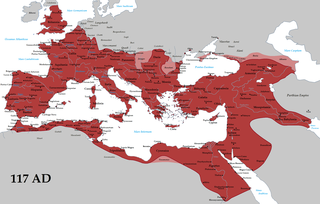
Selinus or Selinous was a port-town on the west coast of ancient Cilicia and later of Isauria, at the mouth of a small river of the same name, now called Musa Çay. This town is memorable in history as the place where the emperor Trajan is said by some authors to have died in 117 CE. After this event the place for a time bore the name of Trajanopolis or Traianopolis; but its bishops afterwards are called bishops of Selinus. Basil of Seleucia describes the place as reduced to a state of insignificance in his time, though it had once been a great commercial town. Selinus was situated on a precipitous rock, surrounded on almost every side by the sea, by which position it was rendered almost impregnable. The whole of the rock, however, was not included in the ancient line of fortifications; inside the walls there still are many traces of houses, but on the outside, and between the foot of the hill and the river, the remains of some large buildings are yet standing, which appear to be a mausoleum, an agora, a theatre, an aqueduct, and some tombs. No longer a residential bishopric, it remains a titular see of the Roman Catholic Church.
Charadrus or Charadros was a town on the coast of ancient Cilicia, between Platanus and Cragus, according to the Stadiasmus. Strabo, who writes it Χαραδροῦς, describes it as a fort with a port below it, and a mountain Andriclus above it. It is described by Francis Beaufort "as an opening through the mountains with a small river." The mountain is mentioned in the Stadiasmus under the name Androcus.
Sura or Soura was a town of ancient Lycia, noted for its oracle of Apollo.
Seroiata was a town of ancient Lycia, between Patara and Phellus. The name is not attested in history, but is derived from epigraphic and other evidence.
Stadia was a town of ancient Caria.
Mokata was an inland town of ancient Paphlagonia inhabited during the Hellenistic period. Its name does not occur in ancient authors, but is inferred from epigraphic and other evidence.
Nauloi was a town of ancient Cilicia.
Laertes was a town of ancient Cilicia. Some have supposed that the philosopher Diogenes Laërtius was from this town. Strabo called it a stronghold.
Juliosebaste or Iuliosebaste, also possibly known as Heliosebaste, was a town of ancient Cilicia and later of Isauria, inhabited during Byzantine times. Under the name of Heliosebaste, it became a bishopric; no longer the seat of a residential bishop, it remains a titular see of the Roman Catholic Church.
Nephelis was a small town of ancient Cilicia, situated, according to Ptolemy, between Antioch and Anemurium; but if, as some suppose, it be the same place as the Zephelium or Zephelion (Ζεφέλιον) mentioned in the Stadiasmus Maris Magni, it ought to be looked for between Selinus and Celenderis. Near the place was a promontory of the same name, where, according to Livy, the fleet of Antiochus the Great was stationed, when, after reducing the towns of Cilicia as far as Selinus, he was engaged in the siege of Coracesium, and where he received the ambassadors of the Rhodians.
Platanus or Platanous was a town on the coast of Cilicia Aspera, west of Anemurium. The Stadiasmus Maris Magni places Platanus 350 stadia from Anemurium, which is most likely incorrect. William Smith posited a distance of 150 stadia.
Rygmanoi was a town on the coast of ancient Cilicia, east of Anemurium at the mouth of the Orymagdos River.
Halae or Halai, or Alae or Alai (Ἄλαι), was a coastal town of ancient Cilicia, inhabited during the Roman and Byzantine eras.
Nisyra was a town of ancient Lydia, inhabited during Roman times. Its name does not occur among ancient authors, but is inferred from epigraphic and other evidence.
Siricae, also known as Siricis, and possibly as Saricha, was a town of ancient Cappadocia on the road from Comana to Melitene, 24 miles northwest of the first.
Antoniopolis was a town of ancient Paphlagonia, inhabited in Roman and Byzantine times.
Thouththourbia was a town of ancient Cilicia, inhabited in Roman times. The name does not occur among ancient authors but is inferred from epigraphic and other evidence.
Olosada was a town of ancient Cilicia, inhabited in Roman times. The name does not occur among ancient authors but is inferred from epigraphic and other evidence.
Papirion, also called Papiriou Castellum and Cherreos Eryma, was a town of ancient Cilicia, inhabited in Byzantine times.
Lauzadeai was a town of ancient Cilicia or of Isauria, inhabited in Byzantine times.


