Sozopolis in Pisidia, which had been called Apollonia (Ἀπολλωνία) and Apollonias (Ἀπολλωνίας) during Seleucid times, was a town in the former Roman province of Pisidia, and is not to be confused with the Thracian Sozopolis in Haemimonto in present-day Bulgaria. Its site may correspond to present-day Uluborlu in Isparta Province, Turkey.
Bageis, Bagis (Βάγις), or Bage (Βάγη) was an ancient Greek city in the province of Lydia in Asia Minor.
Silandus or Silandos was an episcopal city in the late Roman province of Lydia. It was near and gave its name to the present town of Selendi in Manisa Province, Turkey.
Aureliopolis in Lydia is a city in the Roman province of Lydia, previously called Tmolus or in Greek Τμῶλος (Tmolos). It issued coinage under each of these names, and one coin combines both names. In the Synecdemus it appears as Auliou Kome. The name "Aureliopolis" was given in honour of the emperor Marcus Aurelius.
Temnos or Temnus was a small Greek polis (city-state) of ancient Aeolis, later incorporated in the Roman province of Asia, on the western coast of Anatolia. Its bishopric was a suffragan of Ephesus, the capital and metropolitan see of the province, and is included in the Catholic Church's list of titular sees.
Blaundus was a Greek city founded during the Hellenistic period in Asia Minor, presently Anatolia, and is now a Latin Catholic titular bishopric.
Daldis, was a town on the borders of ancient Lydia and Phrygia, a former bishopric, and is now a Latin Catholic titular see. It also minted coins in antiquity with the legend Δαλδιανων. It also bore the name Flaviocaesaria or Phlabiokaisareia, which is not attested among ancient authors but is reconstructed from epigraphic and other evidence.
Briula or Brioula was an ancient city and bishopric of ancient Lydia or of Caria in Asia Minor, which remains a Latin Catholic titular see.
Anineta, also known as Aninetum or Anineton, was a town of ancient Lydia or of Caria, and later of the Roman, and Byzantine empires, located in modern Turkey, the site of an ancient bishopric in and was an important site early in christianity. Anineta remains today a titular see of the Roman Catholic Church in the ecclesiastical province of Ephesus. In addition it minted coins bearing the legend Ἀνινησίων.

Satala or Satala in Lydia was a Roman era city and Bishopric in ancient Lydia.
Acrassus or Akrassos was an ancient Roman and Byzantine-era city in Lydia. in the Roman province of Asia and Lydia. Apparently, it is the same place that Ptolemy calls Nacrasa or Nakrasa, placed on the road from Thyatira to Pergamum.
Cerasa is a titular see of the Roman Catholic Church.

Hyrcanis or Hyrkaneis, also known as Hyrcania, was a Roman and Byzantine-era city and bishopric in ancient Lydia, now in western Turkey. It was situated in the Hyrcanian plain, which is said to have derived its name from a colony of Hyrcanians being settled here by the Persians. They were afterwards mingled with some Macedonians, who also settled in this district, whence they are called by Pliny the Elder and Tacitus "Macedones Hyrcani." The city minted its own coins.
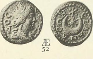
Gordus or Gordos, also known as Julia Gordus or Iulia Gordos, and possibly also known as Porotta, was an ancient Greek city located in eastern Lydia. It was a strategically important town founded by the Seleucid Kings. The Julio-Claudian emperors of the Roman Empire renamed the city Julia Gordos in the 1st century and the city minted its own coins.

The Hyrcani were a people in the classical era. They were mentioned in both the southern coastline of the Caspian Sea and the Hermos River valley in Lydia.
Apollonis , also known as Apollonia (Ἀπολλωνία), Apollones (Ἀπολλώνης), and Apollonias (Ἀπολλωνίας), was a city in ancient Lydia. It was located south of Apollonia in Mysia, where there is a ridge of hills, after crossing which the road to Sardis had on the left Thyatira, and on the right Apollonis, which was 300 stadia from Pergamum, and the same distance from Sardis. It was named after the queen Apollonis, the mother of Eumenes II and Attalus II of Pergamum, in the place of an older city; possibly Doidye. It was mentioned by Cicero. It was destroyed in 17 CE by the great earthquake that destroyed twelve cities of Asia Minor. Tiberius rebuilt the city. It issued coins; those from Marcus Aurelius to Severus Alexander are extant. Apollonis is a titular see of the Roman Catholic Church.
Pionia or Pioniai (Πιονίαι) was a town in the interior of ancient Mysia, on the river Satnioeis, to the northwest of Antandrus, and to the northeast of Gargara. Under the Roman dominion it belonged to the jurisdiction of Adramyttium, and in the ecclesiastical notices it appears as a bishopric of the Hellespontine province. The bishop Aetius represented the city at the Council of Ephesus. No longer the seat of a residential bishop, it remains a titular see of the Roman Catholic Church.
Diocaesarea or Diocaesareia or Diokaisareia, also called Anazarba and Kyinda was a Graeco-Roman town located in Cilicia Trachea mentioned by Ptolemy and the ecclesiastical authorities. It was in time assigned to the late Roman province of Isauria. It was a bishopric; no longer the seat a residential bishop, it remains a titular see of the Roman Catholic Church.
Agatheira was a town of ancient Lydia, inhabited during Hellenistic times. Its site is located near Halitpaşa in Asiatic Turkey. This colony was called a katoikiai, along with Magnesia-by-Sipylus, Hyrcanis, and Thyateira. They were separated from one another by about 15 kilometres (9.3 mi).
Ariarathia or Ariaratheia was a town of ancient Cappadocia, in the Sargarausene region, inhabited during Hellenistic, Roman, and Byzantine times.
