Related Research Articles

Kültepe, also known as Kanesh or Nesha, is an archaeological site in Kayseri Province, Turkey, inhabited from the beginning of the 3rd millennium BC, in the Early Bronze Age. The nearest modern city to Kültepe is Kayseri, about 20km southwest. It consisted of an Upper city, and a lower city, where an Assyrian kārum, trading colony, was found. Its ancient names are recorded in Assyrian and Hittite sources. In cuneiform inscriptions from the 20th and the 19th century BC, the city was mentioned as Kaneš (Kanesh); in later Hittite inscriptions, the city was mentioned as Neša, or occasionally as Aniša (Anisha). In 2014, the archaeological site was inscribed in the Tentative list of World Heritage Sites in Turkey. It is the place where the earliest record of a definitively Indo-European language has been found, Hittite, dated to the 20th century BC.
Tell Ta'yinat is a low-lying ancient tell on the east bank at the bend of the Orontes River where it flows through the Amuq valley, in the Hatay province of southeastern Turkey about 25 kilometers south east of Antakya, and lies near Tell Atchana, the site of the ancient city of Alalakh. Tell Ta'yinat has been proposed as the site of Alalaḫu, inhabited in late 3rd millennium BC, mentioned in Ebla's Palace G archive; and in later times as Kinalua, the capital city of an Iron Age Neo-Hittite kingdom.

Teppe Hasanlu or Hasanlu Tepe is an archeological site of an ancient city located in northwest Iran, a short distance south of Lake Urmia. The nature of its destruction at the end of the 9th century BC essentially froze one layer of the city in time, providing researchers with extremely well preserved buildings, artifacts, and skeletal remains from the victims and enemy combatants of the attack. The site was likely associated with the Mannaeans.

Zincirli Höyük, is an archaeological site located in the Anti-Taurus Mountains of modern Turkey's Gaziantep Province. During its time under the control of the Neo-Assyrian Empire it was called, by them, Sam'al. It was founded at least as far back as the Early Bronze Age and thrived between 3000 and 2000 BC, and on the highest part of the upper mound was found a walled citadel of the Middle Bronze Age. New excavations revealed a monumental complex in the Middle Bronze Age II, and another structure that was destroyed in the mid to late 17th century BC, maybe by Hititte king Hattusili I. This event was recently radiocarbon-dated to sometime between 1632 and 1610 BC, during the late Middle Bronze Age II. The site was thought to have been abandoned during the Hittite and Mitanni periods, but excavations in 2021 season showed evidence of occupation during the Late Bronze Age in Hittite times. It flourished again in the Iron Age, initially under Luwian-speaking Neo-Hittites, and by 920 B.C. had become a kingdom. In the 9th and 8th century BC it came under control of the Neo-Assyrian Empire and by the 7th century BC had become a directly ruled Assyrian province.

Alacahöyük or Alaca Höyük is the site of a Neolithic and Hittite settlement and is an important archaeological site. It is situated near the village of Alacahüyük in the Alaca District of Çorum Province, Turkey, northeast of Boğazkale, where the ancient capital city Hattusa of the Hittite Empire was situated. Its Hittite name is unknown: connections with Arinna, Tawiniya, and Zippalanda have all been suggested.
Beycesultan is an archaeological site in western Anatolia, located about 5 km southwest of the modern-day city of Çivril in the Denizli Province of Turkey. It lies in a bend of an old tributary of Büyük Menderes River.

Gordion was the capital city of ancient Phrygia. It was located at the site of modern Yassıhüyük, about 70–80 km (43–50 mi) southwest of Ankara, in the immediate vicinity of Polatlı district. Gordion's location at the confluence of the Sakarya and Porsuk rivers gave it a strategic location with control over fertile land. Gordion lies where the ancient road between Lydia and Assyria/Babylonia crossed the Sangarius river. Occupation at the site is attested from the Early Bronze Age continuously until the 4th century CE and again in the 13th and 14th centuries CE. The Citadel Mound at Gordion is approximately 13.5 hectares in size, and at its height habitation extended beyond this in an area approximately 100 hectares in size. Gordion is the type site of Phrygian civilization, and its well-preserved destruction level of c. 800 BCE is a chronological linchpin in the region. The long tradition of tumuli at the site is an important record of elite monumentality and burial practice during the Iron Age.

Tell Sabi Abyad is an archaeological site in the Balikh River valley in northern Syria. It lies about 2 kilometers south of Tell Hammam et-Turkman.The site consists of four prehistoric mounds that are numbered Tell Sabi Abyad I to IV. Extensive excavations showed that these sites were inhabited already around 7500 to 5500 BC, although not always at the same time; the settlement shifted back and forth among these four sites.
Kaman-Kalehöyük is a multi-period archaeological site in Kırşehir Province, Turkey, around 100 km south east of Ankara, 6 km east of the town center of Kaman. It is a tell or mound site that was occupied during the Bronze Age, Iron Age and Ottoman periods. Excavations in the mound have been carried out since 1986 under the direction of Sachihiro Omura, on behalf of the Middle Eastern Culture Center in Japan and the Japanese Anatolian Archeology Institute. The distance to Hattusa, the Hittite capital, is about 100 km.
Tell Kazel is an oval-shaped tell that measures 350 m × 325 m at its base, narrowing to 200 m × 200 m at its top. It is located in the Safita district of the Tartus Governorate in Syria in the north of the Akkar plain on the north of the al-Abrash river approximately 18 km (11 mi) south of Tartus.
Cafer Hoyuk or Cafer Höyük is an archaeological site located around 40 kilometres (25 mi) northeast of Malatya, Turkey in the Euphrates valley. It was inhabited over ten thousand years ago during the Neolithic revolution.

The Alaca Höyük bronze standards are a series of bronze objects found among the grave goods in the princely tombs of Alaca Höyük. They are generally understood as cult instruments, probably to be attached to carts.

Kilise Tepe is a mound in Mersin Province, Turkey, just west of the Göksu River, lying 20 kilometers from Mut and 145 kilometers from Mersin. It was initially known as Maltepe which is actually the name of a site on the other bank of the river about four kilometers to the west. The original name of the mound is not known and Kilise Tepe in Turkish means "church-hill" referring to a church ruin. The site is thought to have been part of the land of Tarḫuntašša, formed when Muwatalli II moved the Hittite capital.

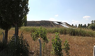
Tell Yunatsite, also known as Ploskata mogila, is situated in the Pazardzhik Province of southern Bulgaria, some 8 kilometres (5 mi) to the west of the district capital Pazardzhik. The tell stands 12 metres (39 ft) above modern ground level and has a diameter of 110 m (360 ft). It is situated on a low terrace at the right bank of the former Topolnitsa riverbed near to its confluence with the Maritsa River. Medieval, Roman, Iron Age, Early Bronze Age, and Copper Age periods have all been attested at the site. The Copper Age tell is associated with the Karanovo culture.

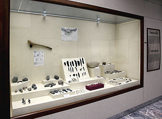
Niğde Archaeological Museum is located in the centre of the Turkish provincial capital, Niğde between Dışarı Cami Sokak and Öğretmenler Caddesi. It contains objects found at sites in the surrounding area, including the tell of Köşk Höyük and the Graeco-Roman city of Tyana, both in the nearby town of Kemerhisar.
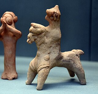
The Euphrates Handmade Syrian Horses and Riders are zoomorphic clay figurines representing horses and horses with riders. They date from the late Iron Age period and were produced in the Middle Euphrates region, alongside anthropomorphic figures known as Euphrates Syrian Pillar Figurines (EU_SPFs).

Tilmen Höyük is an archaeological mound located near the town of Islahiye, in the Gaziantep province of Turkey. It is 225 meters in diameter and 21 meters high on the shores of Karasu River. It is located on the western edge of the Sakçagözü Plain. It is very near the Amanos Mountains.
Usakli Hoyuk is located at Büyüktaslik Village in the district of Sorgun, Yozgat Province, Turkey, to the north of Mount Kerkenes. It was an important Hittite city that flourished in the second millennium BC, and was identified as a possible location of the ancient city of Zippalanda, the centre of the cult of the Storm God.
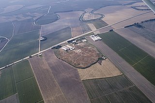
Çadır Höyük is an important ancient settlement and archaeological site in Yozgat Province, Turkey 16 kilometers south of Sorgun. It lies around 70 kilometers from the Hittite capital of Hattuša. The artificial mound contains the remains of some 6,000 years of human settlement ranging from the Middle Chalcolithic era to the Byzantine period. The mound reaches the height of 32 metres above the valley plain. Recent excavators of Cadir Hoyuk have identified this site tentatively with the Hittite city of Zippalanda.
References
- 1 2 "The Year's Work". Anatolian Studies. 30: 197–199. 1980. doi:10.2307/3642790. JSTOR 3642790. S2CID 246047676.
- ↑ "British Institute at Ankara".
- ↑ "Adiyaman Museum". Adiyaman Museum. Retrieved 2011-10-13.