Union County is a county in the northern part of the U.S. state of New Jersey. As of the 2020 United States census, the county was the state's seventh-most-populous county with a population of 575,345, its highest decennial count ever and an increase of 38,846 (+7.2%) from the 2010 census count of 536,499. Its county seat is Elizabeth, which is also the most populous municipality in the county, with a 2020 census population of 137,298, and the largest by area, covering 13.46 square miles (34.9 km2). The county serves as a transition point between the Central Jersey and North Jersey regions of the state.

Morris County is a county located in the U.S. state of New Jersey, about 30 mi (48 km) west of New York City. According to the 2020 census, the county was the state's tenth-most populous county, with a population of 509,285, its highest decennial count ever and an increase of 17,009 (+3.5%) from the 2010 census count of 492,276, which in turn reflected an increase of 22,064 (+11.6%) from the 470,212 counted in the 2000 census, Morris County is part of the New York metropolitan area and is divided into 39 municipalities, with many commuter towns but no large cities. Its county seat is Morristown, in the southeast. The most populous place was Parsippany-Troy Hills Township, with 56,162 residents at the time of the 2020 census, while Rockaway Township covered 45.55 square miles (118.0 km2), the largest total area of any municipality. The county is part of the North Jersey region of the state.

Monmouth County is a county located in the central portion of the U.S. state of New Jersey. It is bordered to its west by Mercer and Middlesex Counties, to its south by Ocean County, to its east by the Atlantic Ocean, and to its north by the Raritan Bay. Monmouth County's geographic area comprises 30% water. The county is part of the Jersey Shore region of the state. It has also been categorized under the Central Jersey region, though it was not among the four counties explicitly listed as included in Central Jersey as part of legislation signed into law in 2023.

Kinnelon is a borough in Morris County, in the U.S. state of New Jersey, located approximately 33 miles (53 km) west of New York City. As of the 2020 United States census, the borough's population was 9,966, a decrease of 282 (−2.8%) from the 2010 census count of 10,248, which in turn reflected an increase of 883 (+9.4%) from the 9,365 counted in the 2000 census. It is a low-density, suburban community, with many parks and trails.

Long Valley is an unincorporated community and census-designated place (CDP) in Washington Township, Morris County, New Jersey, in the United States. Once known as German Valley from its foundation during the colonial era, the community was renamed in response to anti-German sentiment during World War I. As of the 2020 census, the CDP's population was 1,827.

Mendham Township is a township in southwestern Morris County, in the U.S. state of New Jersey, located more than 30 miles (48 km) due west of New York City. As of the 2020 United States census, the township's population was 6,016, an increase of 147 (+2.5%) from the 2010 census count of 5,869, which in turn reflected an increase of 469 (+8.7%) from the 5,400 counted in the 2000 census.

Dover is a town in Morris County, in the U.S. state of New Jersey. Located on the Rockaway River, Dover is about 31 miles (50 km) west of New York City and about 23 miles (37 km) west of Newark, New Jersey. As of the 2020 United States census, the town's population was 18,460, its highest decennial census count ever and an increase of 303 (+1.7%) from the 2010 census count of 18,157, which in turn had reflected a decline of 31 (−0.2%) from the 18,188 counted at the 2000 census.

Mountain Lakes is a borough in Morris County, in the U.S. state of New Jersey, and a suburb of New York City. As of the 2020 United States census, the borough's population was 4,472, an increase of 312 (+7.5%) from the 2010 census count of 4,160, which in turn had reflected a decline of 96 (−2.3%) from the 4,256 recorded at the 2000 census.
Pequannock Township is a township in Morris County, in the U.S. state of New Jersey. As of the 2020 United States census, the township's population was 15,571, an increase of 31 (+0.2%) from the 2010 census count of 15,540, which in turn reflected an increase of 1,652 (+11.9%) from the 13,888 counted in the 2000 census. The primary community in the township is the census-designated place of Pompton Plains.

Washington Township is a township in southwestern Morris County, in the U.S. state of New Jersey. As of the 2020 United States census, the township's population was 18,197, a decrease of 336 (−1.8%) from the 2010 census count of 18,533, which in turn reflected an increase of 941 (+5.3%) from the 17,592 counted in the 2000 census.
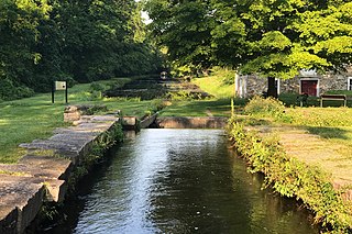
The Morris Canal (1829–1924) was a 107-mile (172 km) common carrier anthracite coal canal across northern New Jersey that connected the two industrial canals in Easton, Pennsylvania across the Delaware River from its western terminus at Phillipsburg, New Jersey to New York Harbor and New York City through its eastern terminals in Newark and on the Hudson River in Jersey City. The canal was sometimes called the Morris and Essex Canal, in error, due to confusion with the nearby and unrelated Morris and Essex Railroad.

The Columbia Trail is a rail trail in rural northwestern New Jersey. It was created from portions of the former Central Railroad of New Jersey High Bridge Branch and stretches from High Bridge, in Hunterdon County, to Washington Township, in Morris County, for a total of 15.1 miles (24.3 km). The trail surface is relatively flat and consists mostly of fine crushed stone.

Schooley's or, officially, Schooleys Mountain is a mountain ridge in northern New Jersey that stretches from Lake Hopatcong in the north to Hampton in the south. It is centrally located within the southern Highlands, positioned almost equidistantly from the Kittatinny Valley in the west and the Piedmont plateau in the east. Schooley's Mountain is also one of the largest ridges in a group of geologically similar and parallel mountains, which include Allamuchy Mountain, Pohatcong Mountain, Scotts Mountain, and Jenny Jump Mountain.

The Skylands Region is a region of New Jersey located in the northern and central parts of the state. It is one of seven tourism regions established by the New Jersey State Department of Tourism; the others are Gateway Region, Greater Atlantic City Region, the Southern Shore Region, the Delaware River Region, the Shore Region, and the Central Jersey Region.

County Route 517 is a county highway in the U.S. state of New Jersey. The highway extends 53.8 miles (86.58 km) from Lamington Road / Oldwick Road in Tewksbury to the New York state line in Vernon where it continues as Orange County Route 26. It passes through mostly rural and exurban communities. Its speed limit varies from as much as 50 mph (80 km/h) to as little as 25 mph (40 km/h).

Hackensack River Greenway, once known as the Hackensack RiverWalk, a is partially constructed greenway along the Newark Bay and Hackensack River in Hudson County, New Jersey, United States.
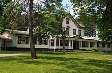
Oak Cottage is a historic home built around 1820 and located in the Schooley's Mountain section of Washington Township in Morris County, New Jersey. The property includes a mill and carriage house built in 1828 and is a contributing property to Schooley's Mountain Historic District, which was listed on the National Register of Historic Places in 1991.
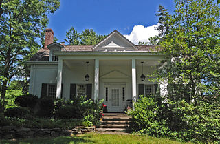
Schooley's Mountain Historic District is a historic district along Schooley's Mountain, Pleasant Grove, and Flocktown Roads, and Heath Lane in the Schooley's Mountain section of Washington Township, Morris County, New Jersey. It was added to the National Register of Historic Places on June 14, 1991 for its significance in architecture, entertainment/recreation, and health/medicine. The district includes 71 contributing buildings, such as the Oak Cottage, site of schoolhouse No. 5, Schooley's Mountain Store, the William W. Marsh House, Christadelphian Bible Camp, the former Heath House Hotel, former Forest Grove Hydropathic Institute, Mine Hill Farm, the Marsh Mine and several private residences and commercial buildings.

Middle Valley is an unincorporated community located along Middle Valley Road and County Route 513 in Washington Township, Morris County, New Jersey. It is located near Long Valley within the valley of the South Branch Raritan River. The Middle Valley Historic District was listed on the state and national registers of historic places in 1989 and 1990.

The Simon Van Duyne House is a historic house located at 58 Maple Avenue in the Pine Brook section of the township of Montville in Morris County, New Jersey. The oldest section was built c. 1750. It was documented by the Historic American Buildings Survey in 1936. The house was later added to the National Register of Historic Places on January 17, 1992, for its significance in architecture. The house was also listed as part of the Dutch Stone Houses in Montville, New Jersey Multiple Property Submission (MPS).